Property Record
25 Putnam St, Staten Island, NY 10312

Save to a Folder
{{folder.Name}}
{{folder.ListingIds.length}} Properties
{{folder.ListingIds.length}} Property
Create a New Folder
Property Detail
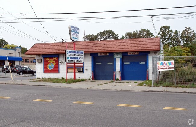
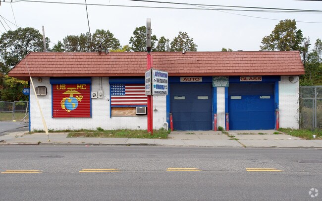
25 Putnam St
05497-0101
STATEN ISLAND
Restaurantbuilding
New York
C8-1
101
B and X Area of moderate flood hazard, usually the area between the limits of the 100-year and 500-year floods.
0.50 AC
2025
Staten Island
2026
Long Island (New York)
014604
New York-Jersey City-White Plains, NY-NJ
3,569 SF
NEARBY LISTINGS FOR SALE OR LEASE
DEMOGRAPHICS near 25 Putnam St
1 mile
3 mile
5 mile
2025 Total Population
45,452
258,341
700,163
2030 Population
45,997
263,856
697,252
Pop Growth 2025-2030
+ 1.20%
+ 2.13%
(0.42%)
Average Age
40
40
40
2025 Total Households
16,532
92,661
242,562
HH Growth 2025-2030
+ 1.31%
+ 2.34%
(0.26%)
Median Household Inc
$72,686
$81,695
$81,240
Avg Household Size
2.50
2.70
2.80
2025 Avg HH Vehicles
1.00
1.00
1.00
Median Home Value
$717,560
$691,474
$723,970
Median Year Built
1949
1960
1955
Nearby Places
Map Layers
Map Styles
 Street
 Aerial
Layers
 Traffic
 Biking
Places
Listings with unknown addresses are not visible on the map
- Restaurants
- Banks
- Shops
- Fitness
- Groceries
PUBLIC TRANSPORTATION
COMMUTER RAIL
Eltingville (Staten Island Railway - New York MTA Subway (The Subway))
Drive
Walk
Distance
Eltingville (Staten Island Railway - New York MTA Subway (The Subway))
0 min
3 min
0.1 mi
Great Kills (Staten Island Railway - New York MTA Subway (The Subway))
Drive
Walk
Distance
Great Kills (Staten Island Railway - New York MTA Subway (The Subway))
3 min
17 min
0.9 mi
AIRPORT
Newark Liberty International
Drive
Walk
Distance
Newark Liberty International
30 min
17.1 mi
LaGuardia
Drive
Walk
Distance
LaGuardia
49 min
27.5 mi
John F Kennedy International
Drive
Walk
Distance
John F Kennedy International
48 min
30.1 mi
Freight Ports
New York Container Terminal
Drive
Walk
Distance
New York Container Terminal
16 min
7.6 mi
Nearby Properties
Address
Land Use
TOTAL SIZE
Lot Size
Zoning
Address
Land Use
TOTAL SIZE
Lot Size
Zoning
3,600 SF
731.18 AC
PARK
Address
Land Use
TOTAL SIZE
Lot Size
Zoning
237 AC
M1-1
Address
Land Use
TOTAL SIZE
Lot Size
Zoning
118 AC
M3-1
Address
Land Use
TOTAL SIZE
Lot Size
Zoning
146 AC
PARK
Address
Land Use
TOTAL SIZE
Lot Size
Zoning
1,258,042 SF
14.47 AC
C4-1
Address
Land Use
TOTAL SIZE
Lot Size
Zoning
411,000 SF
18.54 AC
R3X
Address
Land Use
TOTAL SIZE
Lot Size
Zoning
5,214 SF
93 AC
M3-1
Address
Land Use
TOTAL SIZE
Lot Size
Zoning
195,395 SF
12.04 AC
R3-2
Address
Land Use
TOTAL SIZE
Lot Size
Zoning
11,140 SF
170.60 AC
PARK
Address
Land Use
TOTAL SIZE
Lot Size
Zoning
220,240 SF
5.77 AC
R3X
Address
Land Use
TOTAL SIZE
Lot Size
Zoning
294,320 SF
15 AC
R3-2
Address
Land Use
TOTAL SIZE
Lot Size
Zoning
38.58 AC
PARK
Address
Land Use
TOTAL SIZE
Lot Size
Zoning
505,000 SF
3.79 AC
R3A
Address
Land Use
TOTAL SIZE
Lot Size
Zoning
33.36 AC
PARK
Address
Land Use
TOTAL SIZE
Lot Size
Zoning
74,000 SF
523.69 AC
R3-2
Address
Land Use
TOTAL SIZE
Lot Size
Zoning
377,678 SF
25.40 AC
C4-1
Address
Land Use
TOTAL SIZE
Lot Size
Zoning
319,000 SF
18.76 AC
C4-1
Address
Land Use
TOTAL SIZE
Lot Size
Zoning
180,000 SF
91.83 AC
M3-1
Address
Land Use
TOTAL SIZE
Lot Size
Zoning
28.97 AC
PARK
Address
Land Use
TOTAL SIZE
Lot Size
Zoning
192,000 SF
5.47 AC
R3X
Address
Land Use
TOTAL SIZE
Lot Size
Zoning
168,050 SF
9.66 AC
R3-2
Address
Land Use
TOTAL SIZE
Lot Size
Zoning
26.08 AC
PARK
Address
Land Use
TOTAL SIZE
Lot Size
Zoning
80,875 SF
283.97 AC
M3-1
Address
Land Use
TOTAL SIZE
Lot Size
Zoning
109,000 SF
3.38 AC
R3X
Address
Land Use
TOTAL SIZE
Lot Size
Zoning
26.45 AC
PARK
Address
Land Use
TOTAL SIZE
Lot Size
Zoning
180,000 SF
2.28 AC
R2
Address
Land Use
TOTAL SIZE
Lot Size
Zoning
126,000 SF
6.36 AC
R3-2
Address
Land Use
TOTAL SIZE
Lot Size
Zoning
21.58 AC
PARK
Address
Land Use
TOTAL SIZE
Lot Size
Zoning
27.90 AC
R3X
Address
Land Use
TOTAL SIZE
Lot Size
Zoning
24,000 SF
7.46 AC
C8-1
The World's #1 Commercial Real Estate Marketplace
Connect with us
© 2026 CoStar Group
The information above has been obtained from sources believed reliable. While we do not doubt its accuracy we have not verified it and make no guarantee, warranty or representation about it. It is your responsibility to independently confirm its accuracy and completeness. Any projections, opinions, assumptions, or estimates used are for example only and do not represent the current or future performance of the property. The value of this transaction to you depends on tax and other factors which should be evaluated by your tax, financial, and legal advisors. You and your advisors should conduct a careful, independent investigation of the property to determine to your satisfaction the suitability of the property for your needs.