Property Record
25 Railside Way, Palm Coast, FL 32137
NEARBY LISTINGS FOR SALE OR LEASE
Property Detail
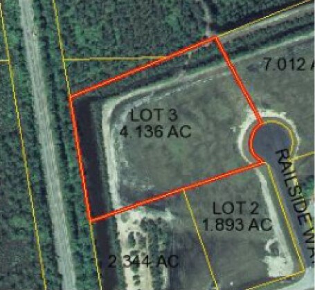
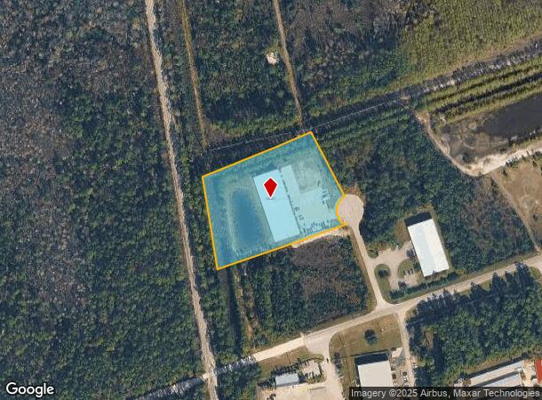
25 Railside Way
Deltona-Daytona Beach-Ormond Beach, FL
Palm Coast Industrial Park
16-11-30-4939-00000-0030
PALM COAST INDUSTRIAL PARK PHASE III LOT 3 MB 34 PG 34 4.136 AC OR 1056 PG 377 OR 1063 PG 20 OR 1426 PG 358 OR 1808/1073 OR 2042/1080 OR 2227/987 OR 2323/1075 OR 2396/1097
Industrialcondominium
Flagler
X
Florida
12035C0120E
3
2023
4.14 AC
2024
Daytona Area
060206
Other Market Areas
15,121 SF
DEMOGRAPHICS near 25 Railside Way
1 Mile
3 Mile
5 Mile
2024 Total Population
43
18,657
68,364
2029 Population
53
22,557
83,394
Pop Growth 2024-2029
+ 23.26%
+ 20.90%
+ 21.99%
Average Age
43
47
46
2024 Total Households
16
7,358
26,901
HH Growth 2024-2029
+ 25.00%
+ 20.10%
+ 21.19%
Median Household Inc
$65,000
$61,601
$62,506
Avg Household Size
2.40
2.50
2.50
2024 Avg HH Vehicles
2.00
2.00
2.00
Median Home Value
$150,000
$251,815
$255,011
Median Year Built
1989
1996
2000
Nearby Places
- Restaurants
- Banks
- Shops
- Fitness
- Groceries
PUBLIC TRANSPORTATION
AIRPORT
Daytona Beach International
DRIVE
WALK
Distance
Daytona Beach International
46 min
34.2 mi
Freight Ports
Jacksonville Port
DRIVE
WALK
Distance
Jacksonville Port
80 min
64.6 mi
SALE & LEASE HISTORY
LISTING DATE
SALE/LEASE

Oct 11, 2018
For Sale
Nearby Properties
Address
Land Use
TOTAL SIZE
Lot Size
Zoning
Address
Land Use
TOTAL SIZE
Lot Size
Zoning
76,792 SF
10.05 AC
COM-2
Address
Land Use
TOTAL SIZE
Lot Size
Zoning
298,470 SF
34.44 AC
MFR-2
Address
Land Use
TOTAL SIZE
Lot Size
Zoning
209,585 SF
40 AC
MPD
Address
Land Use
TOTAL SIZE
Lot Size
Zoning
85.89 AC
PSP
Address
Land Use
TOTAL SIZE
Lot Size
Zoning
137,280 SF
64.40 AC
COM-3
Address
Land Use
TOTAL SIZE
Lot Size
Zoning
167,892 SF
76.77 AC
PSP
Address
Land Use
TOTAL SIZE
Lot Size
Zoning
85,307 SF
4.31 AC
IND-1
Address
Land Use
TOTAL SIZE
Lot Size
Zoning
75,297 SF
15.55 AC
PSP
Address
Land Use
TOTAL SIZE
Lot Size
Zoning
144,642 SF
17.44 AC
IND-1
Address
Land Use
TOTAL SIZE
Lot Size
Zoning
61,313 SF
7.78 AC
COM-2
Address
Land Use
TOTAL SIZE
Lot Size
Zoning
94,320 SF
22.19 AC
PSP
Address
Land Use
TOTAL SIZE
Lot Size
Zoning
77,816 SF
5.95 AC
COM-3
Address
Land Use
TOTAL SIZE
Lot Size
Zoning
98.85 AC
MFR-2
Address
Land Use
TOTAL SIZE
Lot Size
Zoning
88,704 SF
7.96 AC
Address
Land Use
TOTAL SIZE
Lot Size
Zoning
28,335 SF
19.31 AC
PSP
Address
Land Use
TOTAL SIZE
Lot Size
Zoning
27,218 SF
8.43 AC
COM-3
Address
Land Use
TOTAL SIZE
Lot Size
Zoning
35,189 SF
30.23 AC
PSP
Address
Land Use
TOTAL SIZE
Lot Size
Zoning
5,264 SF
9.61 AC
PSP
Address
Land Use
TOTAL SIZE
Lot Size
Zoning
45,409 SF
3.90 AC
OFC-2
Address
Land Use
TOTAL SIZE
Lot Size
Zoning
88.80 AC
MPD
Address
Land Use
TOTAL SIZE
Lot Size
Zoning
48,777 SF
10.31 AC
PSP
Address
Land Use
TOTAL SIZE
Lot Size
Zoning
21,598 SF
6.53 AC
Address
Land Use
TOTAL SIZE
Lot Size
Zoning
21,512 SF
7.48 AC
PSP
Address
Land Use
TOTAL SIZE
Lot Size
Zoning
42,838 SF
5.34 AC
OFC-2
Address
Land Use
TOTAL SIZE
Lot Size
Zoning
91,202 SF
4 AC
COM-2
Address
Land Use
TOTAL SIZE
Lot Size
Zoning
25,300 SF
5 AC
IND-1
Address
Land Use
TOTAL SIZE
Lot Size
Zoning
23,024 SF
5.52 AC
PSP
The World's #1 Commercial Real Estate Marketplace
Connect with us
© 2025 CoStar Group
The information above has been obtained from sources believed reliable. While we do not doubt its accuracy we have not verified it and make no guarantee, warranty or representation about it. It is your responsibility to independently confirm its accuracy and completeness. Any projections, opinions, assumptions, or estimates used are for example only and do not represent the current or future performance of the property. The value of this transaction to you depends on tax and other factors which should be evaluated by your tax, financial, and legal advisors. You and your advisors should conduct a careful, independent investigation of the property to determine to your satisfaction the suitability of the property for your needs.