Property Record
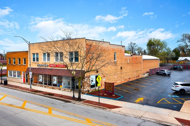
25 S Cass Ave, Westmont, IL 60559


Current Lease Availabilities
NEARBY LISTINGS FOR SALE OR LEASE
Property Detail
25 S Cass Ave
Chicago-Naperville-Elgin, IL-IN-WI
Mcintosh Fairmont Pk
09-10-303-004
MCINTOSH FAIRMONT PK
Commercialnec
DuPage
X
Illinois
17043C0186J
28
2024
0.23 AC
2024
Eastern East/West Corr
845000
Chicago
2,262 SF
DEMOGRAPHICS near 25 S Cass Ave
1 Mile
3 Mile
5 Mile
2024 Total Population
16,300
106,769
246,916
2029 Population
16,059
105,772
245,682
Pop Growth 2024-2029
(1.48%)
(0.93%)
(0.50%)
Average Age
41
43
43
2024 Total Households
6,205
41,822
98,113
HH Growth 2024-2029
(1.64%)
(1.09%)
(0.53%)
Median Household Inc
$98,169
$111,151
$106,192
Avg Household Size
2.60
2.50
2.40
2024 Avg HH Vehicles
2.00
2.00
2.00
Median Home Value
$425,476
$456,592
$417,987
Median Year Built
1968
1974
1975
Nearby Places
Map Layers
Map Styles
 Street
 Aerial
- Restaurants
- Banks
- Shops
- Fitness
- Groceries
PUBLIC TRANSPORTATION
COMMUTER RAIL
Westmont Station (Burlington Northern-Santa Fe Railway Line - Northeast Illinois Regional Commuter Railroad (Metra))
DRIVE
WALK
Distance
Westmont Station (Burlington Northern-Santa Fe Railway Line - Northeast Illinois Regional Commuter Railroad (Metra))
0 min
3 min
0.2 mi
Downers Grove Fairview Avenue Station (Burlington Northern-Santa Fe Railway Line - Northeast Illinois Regional Commuter Railroad (Metra))
DRIVE
WALK
Distance
Downers Grove Fairview Avenue Station (Burlington Northern-Santa Fe Railway Line - Northeast Illinois Regional Commuter Railroad (Metra))
3 min
1.8 mi
AIRPORT
Chicago Midway International
DRIVE
WALK
Distance
Chicago Midway International
23 min
12.8 mi
Chicago O'Hare International
DRIVE
WALK
Distance
Chicago O'Hare International
30 min
20.6 mi
Freight Ports
Port Milwaukee
DRIVE
WALK
Distance
Port Milwaukee
111 min
92.3 mi
Nearby Properties
Address
Land Use
TOTAL SIZE
Lot Size
Zoning
Address
Land Use
TOTAL SIZE
Lot Size
Zoning
439,070 SF
38.77 AC
C
Address
Land Use
TOTAL SIZE
Lot Size
Zoning
403,248 SF
24.98 AC
M
Address
Land Use
TOTAL SIZE
Lot Size
Zoning
1.34 AC
Address
Land Use
TOTAL SIZE
Lot Size
Zoning
470,838 SF
17.13 AC
M
Address
Land Use
TOTAL SIZE
Lot Size
Zoning
183,080 SF
20.86 AC
C
Address
Land Use
TOTAL SIZE
Lot Size
Zoning
368,233 SF
16.12 AC
Address
Land Use
TOTAL SIZE
Lot Size
Zoning
388,561 SF
12.77 AC
Address
Land Use
TOTAL SIZE
Lot Size
Zoning
274,406 SF
17.67 AC
M
Address
Land Use
TOTAL SIZE
Lot Size
Zoning
205,315 SF
0.87 AC
Address
Land Use
TOTAL SIZE
Lot Size
Zoning
175,695 SF
1.01 AC
C
Address
Land Use
TOTAL SIZE
Lot Size
Zoning
182,295 SF
21.84 AC
C
Address
Land Use
TOTAL SIZE
Lot Size
Zoning
230,187 SF
15.38 AC
M
Address
Land Use
TOTAL SIZE
Lot Size
Zoning
202,562 SF
16.17 AC
M
Address
Land Use
TOTAL SIZE
Lot Size
Zoning
265,215 SF
18.12 AC
C
Address
Land Use
TOTAL SIZE
Lot Size
Zoning
108,021 SF
0.89 AC
Address
Land Use
TOTAL SIZE
Lot Size
Zoning
91,818 SF
7.87 AC
Address
Land Use
TOTAL SIZE
Lot Size
Zoning
61,553 SF
2.35 AC
M
Address
Land Use
TOTAL SIZE
Lot Size
Zoning
118,665 SF
1.11 AC
C
Address
Land Use
TOTAL SIZE
Lot Size
Zoning
58,902 SF
9.47 AC
Address
Land Use
TOTAL SIZE
Lot Size
Zoning
174,930 SF
5.61 AC
C
Address
Land Use
TOTAL SIZE
Lot Size
Zoning
121,968 SF
2.07 AC
Address
Land Use
TOTAL SIZE
Lot Size
Zoning
23,043 SF
9.85 AC
M
Address
Land Use
TOTAL SIZE
Lot Size
Zoning
113,756 SF
2.60 AC
C
Address
Land Use
TOTAL SIZE
Lot Size
Zoning
146,856 SF
7.18 AC
A
Address
Land Use
TOTAL SIZE
Lot Size
Zoning
207,084 SF
9.41 AC
N
Address
Land Use
TOTAL SIZE
Lot Size
Zoning
82,834 SF
7.55 AC
C
Address
Land Use
TOTAL SIZE
Lot Size
Zoning
22,770 SF
7.48 AC
M
Address
Land Use
TOTAL SIZE
Lot Size
Zoning
113,961 SF
6.94 AC
M
Address
Land Use
TOTAL SIZE
Lot Size
Zoning
95,408 SF
65.20 AC
R
Address
Land Use
TOTAL SIZE
Lot Size
Zoning
8.91 AC
The World's #1 Commercial Real Estate Marketplace
Connect with us
© 2025 CoStar Group
The information above has been obtained from sources believed reliable. While we do not doubt its accuracy we have not verified it and make no guarantee, warranty or representation about it. It is your responsibility to independently confirm its accuracy and completeness. Any projections, opinions, assumptions, or estimates used are for example only and do not represent the current or future performance of the property. The value of this transaction to you depends on tax and other factors which should be evaluated by your tax, financial, and legal advisors. You and your advisors should conduct a careful, independent investigation of the property to determine to your satisfaction the suitability of the property for your needs.