Property Record
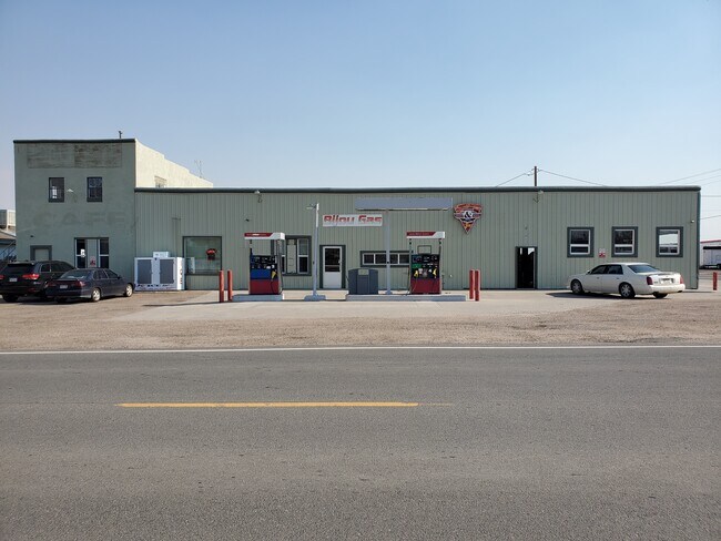
25 W Highway 40, Byers, CO 80103

NEARBY LISTINGS FOR SALE OR LEASE
-
-
View all Byers listings for sale on LoopNet.com
Property Detail
25 W Highway 40
1985-09-3-00-011
SECTION 09 TOWNSHIP 04 RANGE 61 BEG 370 FT N & 1320 FT E OF SWCOR SEC 9, TH N 141.9 FT, TH W 139.1 FT, TH S 102.6 FT TO N LINE HIWAY 40, TH SELY 144 FT TO BEG 9-4-61
Restaurantbuilding
Arapahoe
X
Colorado
08005C0325K
0.39 AC
2024
Southeast Outlying
2024
Denver
007101
Denver-Aurora-Lakewood, CO
5,280 SF
DEMOGRAPHICS near 25 W Highway 40
1 Mile
3 Mile
5 Mile
2024 Total Population
876
1,213
1,718
2029 Population
827
1,155
1,661
Pop Growth 2024-2029
(5.59%)
(4.78%)
(3.32%)
Average Age
41
41
41
2024 Total Households
331
451
626
HH Growth 2024-2029
(5.74%)
(4.88%)
(3.35%)
Median Household Inc
$97,499
$100,101
$101,351
Avg Household Size
2.60
2.60
2.70
2024 Avg HH Vehicles
3.00
3.00
3.00
Median Home Value
$539,855
$571,078
$609,425
Median Year Built
1975
1978
1985
Nearby Places
Map Layers
Map Styles
 Street
 Aerial
- Restaurants
- Banks
- Shops
- Fitness
- Groceries
PUBLIC TRANSPORTATION
AIRPORT
Denver International
DRIVE
WALK
Distance
Denver International
44 min
39.5 mi
SALE & LEASE HISTORY
LISTING DATE
SALE/LEASE

Aug 19, 2020
For Sale
Nearby Properties
Address
Land Use
TOTAL SIZE
Lot Size
Zoning
Address
Land Use
TOTAL SIZE
Lot Size
Zoning
80 AC
AO
Address
Land Use
TOTAL SIZE
Lot Size
Zoning
9,621 SF
0.37 AC
Address
Land Use
TOTAL SIZE
Lot Size
Zoning
11,762 SF
1.46 AC
PUD
Address
Land Use
TOTAL SIZE
Lot Size
Zoning
280 SF
7 AC
Address
Land Use
TOTAL SIZE
Lot Size
Zoning
15,213 SF
0.03 AC
Address
Land Use
TOTAL SIZE
Lot Size
Zoning
16,352 SF
1.73 AC
Address
Land Use
TOTAL SIZE
Lot Size
Zoning
4,658 SF
0.67 AC
Address
Land Use
TOTAL SIZE
Lot Size
Zoning
1.93 AC
AB5
Address
Land Use
TOTAL SIZE
Lot Size
Zoning
8.90 AC
Address
Land Use
TOTAL SIZE
Lot Size
Zoning
13,614 SF
777.12 AC
AAE
Address
Land Use
TOTAL SIZE
Lot Size
Zoning
9,788 SF
1.60 AC
AR1
Address
Land Use
TOTAL SIZE
Lot Size
Zoning
3,637 SF
80.22 AC
AA1
Address
Land Use
TOTAL SIZE
Lot Size
Zoning
2,188 SF
35.52 AC
AA1
Address
Land Use
TOTAL SIZE
Lot Size
Zoning
3,690 SF
0.51 AC
Address
Land Use
TOTAL SIZE
Lot Size
Zoning
2,313 SF
512.14 AC
AAE
Address
Land Use
TOTAL SIZE
Lot Size
Zoning
7,244 SF
0.15 AC
Address
Land Use
TOTAL SIZE
Lot Size
Zoning
7,962 SF
0.50 AC
Address
Land Use
TOTAL SIZE
Lot Size
Zoning
1,300 SF
0.65 AC
AR3
Address
Land Use
TOTAL SIZE
Lot Size
Zoning
5,752 SF
0.22 AC
Address
Land Use
TOTAL SIZE
Lot Size
Zoning
5,136 SF
35.03 AC
AA1
Address
Land Use
TOTAL SIZE
Lot Size
Zoning
5,125 SF
35.99 AC
AA1
Address
Land Use
TOTAL SIZE
Lot Size
Zoning
4,500 SF
0.48 AC
Address
Land Use
TOTAL SIZE
Lot Size
Zoning
5,572 SF
35.07 AC
AA1
Address
Land Use
TOTAL SIZE
Lot Size
Zoning
5,400 SF
0.27 AC
Address
Land Use
TOTAL SIZE
Lot Size
Zoning
0.77 AC
AB5
Address
Land Use
TOTAL SIZE
Lot Size
Zoning
6,275 SF
72.40 AC
AA1
Address
Land Use
TOTAL SIZE
Lot Size
Zoning
5,250 SF
0.13 AC
Address
Land Use
TOTAL SIZE
Lot Size
Zoning
227.79 AC
AAE
Address
Land Use
TOTAL SIZE
Lot Size
Zoning
7,595 SF
19.14 AC
AA1
The World's #1 Commercial Real Estate Marketplace
Connect with us
© 2025 CoStar Group
The information above has been obtained from sources believed reliable. While we do not doubt its accuracy we have not verified it and make no guarantee, warranty or representation about it. It is your responsibility to independently confirm its accuracy and completeness. Any projections, opinions, assumptions, or estimates used are for example only and do not represent the current or future performance of the property. The value of this transaction to you depends on tax and other factors which should be evaluated by your tax, financial, and legal advisors. You and your advisors should conduct a careful, independent investigation of the property to determine to your satisfaction the suitability of the property for your needs.