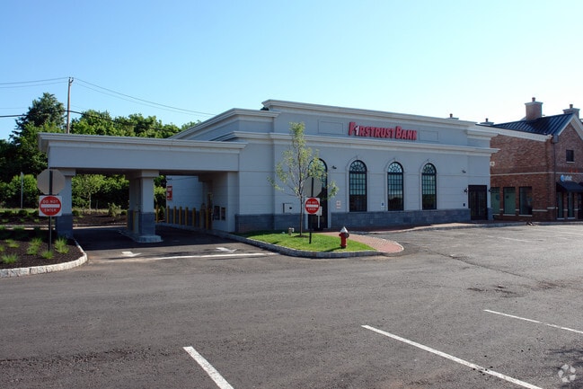
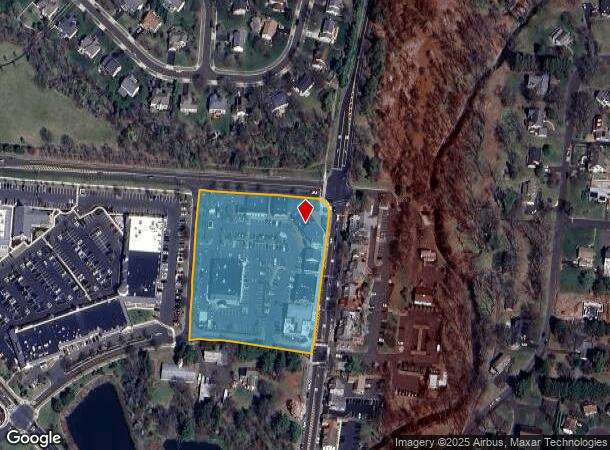
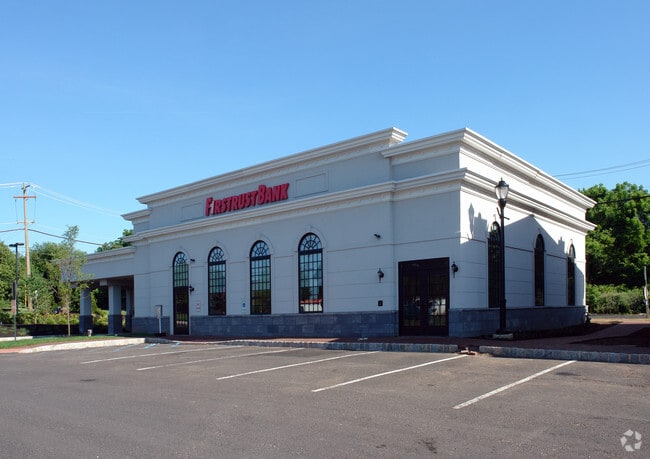
Property Record
282-304 N Sycamore St, Newtown, PA 18940
NEARBY LISTINGS FOR SALE OR LEASE
Property Detail
282-304 N Sycamore St
Philadelphia-Camden-Wilmington, PA-NJ-DE-MD
Minor Subdivision
29-003-024-002
3.9618 AC LOT #2 S W COR SYCAORE ST & DURHAM RD
Regionalshoppingcenterormallwithanchorstore
Bucks
X
Pennsylvania
42017C0427K
2
2024
3.96 AC
2025
Lower Bucks County
105208
Philadelphia
36,490 SF
DEMOGRAPHICS near 282-304 N Sycamore St
1 Mile
3 Mile
5 Mile
2024 Total Population
7,199
41,151
103,213
2029 Population
7,190
40,853
102,598
Pop Growth 2024-2029
(0.13%)
(0.72%)
(0.60%)
Average Age
45
45
45
2024 Total Households
2,832
15,903
38,468
HH Growth 2024-2029
(0.11%)
(0.82%)
(0.64%)
Median Household Inc
$144,419
$137,042
$137,720
Avg Household Size
2.50
2.50
2.60
2024 Avg HH Vehicles
2.00
2.00
2.00
Median Home Value
$632,595
$507,658
$491,734
Median Year Built
1981
1985
1984
Nearby Places
Map Layers
Map Styles
 Street
 Aerial
- Restaurants
- Banks
- Shops
- Fitness
- Groceries
PUBLIC TRANSPORTATION
COMMUTER RAIL
Langhorne (R3 - Southeastern Pennsylvania Transportation Authority Regional Rail (SEPTA Regional Rail))
DRIVE
WALK
Distance
Langhorne (R3 - Southeastern Pennsylvania Transportation Authority Regional Rail (SEPTA Regional Rail))
11 min
6.1 mi
Yardley (R3 - Southeastern Pennsylvania Transportation Authority Regional Rail (SEPTA Regional Rail))
DRIVE
WALK
Distance
Yardley (R3 - Southeastern Pennsylvania Transportation Authority Regional Rail (SEPTA Regional Rail))
13 min
6.8 mi
AIRPORT
Trenton Mercer
DRIVE
WALK
Distance
Trenton Mercer
17 min
9.7 mi
Philadelphia International
DRIVE
WALK
Distance
Philadelphia International
60 min
38.1 mi
Lehigh Valley International
DRIVE
WALK
Distance
Lehigh Valley International
78 min
46.2 mi
Freight Ports
Port of Philadelphia
DRIVE
WALK
Distance
Port of Philadelphia
39 min
21.3 mi
Nearby Properties
Address
Land Use
TOTAL SIZE
Lot Size
Zoning
Address
Land Use
TOTAL SIZE
Lot Size
Zoning
58,221 SF
14.42 AC
R1
Address
Land Use
TOTAL SIZE
Lot Size
Zoning
381,016 SF
52.25 AC
OR
Address
Land Use
TOTAL SIZE
Lot Size
Zoning
113,929 SF
10.43 AC
VRI
Address
Land Use
TOTAL SIZE
Lot Size
Zoning
78,743 SF
44.63 AC
IP
Address
Land Use
TOTAL SIZE
Lot Size
Zoning
57,804 SF
20.69 AC
AO
Address
Land Use
TOTAL SIZE
Lot Size
Zoning
102,348 SF
0.60 AC
RA
Address
Land Use
TOTAL SIZE
Lot Size
Zoning
104,204 SF
12.99 AC
RA3
Address
Land Use
TOTAL SIZE
Lot Size
Zoning
162,990 SF
10.75 AC
LI
Address
Land Use
TOTAL SIZE
Lot Size
Zoning
131,927 SF
14.73 AC
LI
Address
Land Use
TOTAL SIZE
Lot Size
Zoning
106,250 SF
14.41 AC
OR
Address
Land Use
TOTAL SIZE
Lot Size
Zoning
94,737 SF
1.66 AC
OR
Address
Land Use
TOTAL SIZE
Lot Size
Zoning
11.77 AC
R1
Address
Land Use
TOTAL SIZE
Lot Size
Zoning
151,803 SF
12.54 AC
LI
Address
Land Use
TOTAL SIZE
Lot Size
Zoning
65,124 SF
8.52 AC
PG
Address
Land Use
TOTAL SIZE
Lot Size
Zoning
16,170 SF
40 AC
OR
Address
Land Use
TOTAL SIZE
Lot Size
Zoning
35,713 SF
7.09 AC
L1
Address
Land Use
TOTAL SIZE
Lot Size
Zoning
78,848 SF
0.70 AC
Address
Land Use
TOTAL SIZE
Lot Size
Zoning
64,164 SF
8.29 AC
PC
Address
Land Use
TOTAL SIZE
Lot Size
Zoning
1.31 AC
OR
Address
Land Use
TOTAL SIZE
Lot Size
Zoning
109,704 SF
14.12 AC
LI
Address
Land Use
TOTAL SIZE
Lot Size
Zoning
114,710 SF
10.93 AC
R4
Address
Land Use
TOTAL SIZE
Lot Size
Zoning
73,245 SF
24.10 AC
OR
Address
Land Use
TOTAL SIZE
Lot Size
Zoning
90,400 SF
10.46 AC
OR
Address
Land Use
TOTAL SIZE
Lot Size
Zoning
76,984 SF
1.23 AC
OR
Address
Land Use
TOTAL SIZE
Lot Size
Zoning
48,948 SF
4.48 AC
VRI
Address
Land Use
TOTAL SIZE
Lot Size
Zoning
20,439 SF
0.87 AC
OR
Address
Land Use
TOTAL SIZE
Lot Size
Zoning
61,740 SF
0.71 AC
OR
Address
Land Use
TOTAL SIZE
Lot Size
Zoning
34,186 SF
3.89 AC
VI
Address
Land Use
TOTAL SIZE
Lot Size
Zoning
83,816 SF
9.27 AC
LI
The World's #1 Commercial Real Estate Marketplace
Connect with us
© 2026 CoStar Group
The information above has been obtained from sources believed reliable. While we do not doubt its accuracy we have not verified it and make no guarantee, warranty or representation about it. It is your responsibility to independently confirm its accuracy and completeness. Any projections, opinions, assumptions, or estimates used are for example only and do not represent the current or future performance of the property. The value of this transaction to you depends on tax and other factors which should be evaluated by your tax, financial, and legal advisors. You and your advisors should conduct a careful, independent investigation of the property to determine to your satisfaction the suitability of the property for your needs.