Property Record
250 Balboa Pl, Needles, CA 92363

NEARBY LISTINGS FOR SALE OR LEASE
Property Detail
250 Balboa Pl
0660-081-39
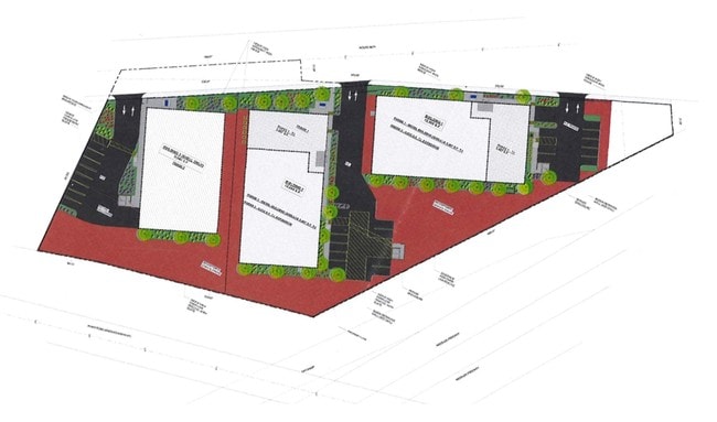
Parcel Map No 19995
Lightindustrial
PARCEL MAP 19995 PARCEL 3 BOOK 253 PAGE 40
X
San Bernardino
04015C5375J
California
2025
0.80 AC
2025
San Bernardino Outlying
010700
Inland Empire (California)
12,500 SF
Riverside-San Bernardino-Ontario, CA
DEMOGRAPHICS near 250 Balboa Pl
1 mile
3 mile
5 mile
2024 Total Population
1,104
9,694
12,994
2029 Population
1,169
10,430
14,126
Pop Growth 2024-2029
+ 5.89%
+ 7.59%
+ 8.71%
Average Age
48
43
44
2024 Total Households
493
3,918
5,332
HH Growth 2024-2029
+ 5.68%
+ 7.63%
+ 9.08%
Median Household Inc
$51,909
$42,177
$41,097
Avg Household Size
2.30
2.50
2.40
2024 Avg HH Vehicles
2.00
2.00
2.00
Median Home Value
$277,550
$178,482
$199,999
Median Year Built
1986
1986
1986
Nearby Places
Map Layers
Map Styles
 Street
 Aerial
Transit
 Traffic
 Biking
Places
Listings with unknown addresses are not visible on the map
- Restaurants
- Banks
- Shops
- Fitness
- Groceries
PUBLIC TRANSPORTATION
COMMUTER RAIL
Drive
Walk
Distance
4 min
2.2 mi
AIRPORT
Laughlin/Bullhead International
Drive
Walk
Distance
Laughlin/Bullhead International
46 min
26.8 mi
SALE & LEASE HISTORY
LISTING DATE
SALE/LEASE

Jan 11, 2018
For Sale
Nearby Properties
Address
Land Use
TOTAL SIZE
Lot Size
Zoning
Address
Land Use
TOTAL SIZE
Lot Size
Zoning
46,499 SF
1.56 AC
Address
Land Use
TOTAL SIZE
Lot Size
Zoning
42,840 SF
2.57 AC
Address
Land Use
TOTAL SIZE
Lot Size
Zoning
80,000 SF
4.53 AC
Address
Land Use
TOTAL SIZE
Lot Size
Zoning
46,400 SF
1.60 AC
Address
Land Use
TOTAL SIZE
Lot Size
Zoning
164,720 SF
7.52 AC
Address
Land Use
TOTAL SIZE
Lot Size
Zoning
30,375 SF
14.89 AC
Address
Land Use
TOTAL SIZE
Lot Size
Zoning
500,500 SF
23.20 AC
Address
Land Use
TOTAL SIZE
Lot Size
Zoning
46,500 SF
2.17 AC
Address
Land Use
TOTAL SIZE
Lot Size
Zoning
90,750 SF
6.07 AC
Address
Land Use
TOTAL SIZE
Lot Size
Zoning
107,025 SF
9.28 AC
Address
Land Use
TOTAL SIZE
Lot Size
Zoning
29,181 SF
1.42 AC
Address
Land Use
TOTAL SIZE
Lot Size
Zoning
31,450 SF
2.50 AC
Address
Land Use
TOTAL SIZE
Lot Size
Zoning
20,000 SF
1.87 AC
Address
Land Use
TOTAL SIZE
Lot Size
Zoning
54,291 SF
6.96 AC
Address
Land Use
TOTAL SIZE
Lot Size
Zoning
61,750 SF
2.07 AC
Address
Land Use
TOTAL SIZE
Lot Size
Zoning
10.04 AC
Address
Land Use
TOTAL SIZE
Lot Size
Zoning
46,400 SF
21.61 AC
Address
Land Use
TOTAL SIZE
Lot Size
Zoning
902,998 SF
13.80 AC
Address
Land Use
TOTAL SIZE
Lot Size
Zoning
24,726 SF
2.15 AC
Address
Land Use
TOTAL SIZE
Lot Size
Zoning
51,234 SF
3.40 AC
Address
Land Use
TOTAL SIZE
Lot Size
Zoning
138,537 SF
6.30 AC
Address
Land Use
TOTAL SIZE
Lot Size
Zoning
76,032 SF
6.45 AC
Address
Land Use
TOTAL SIZE
Lot Size
Zoning
4,941 SF
0.52 AC
Address
Land Use
TOTAL SIZE
Lot Size
Zoning
12,400 SF
0.21 AC
Address
Land Use
TOTAL SIZE
Lot Size
Zoning
19,906 SF
9.77 AC
Address
Land Use
TOTAL SIZE
Lot Size
Zoning
40,136 SF
4.52 AC
Address
Land Use
TOTAL SIZE
Lot Size
Zoning
69,900 SF
5.89 AC
The World's #1 Commercial Real Estate Marketplace
Connect with us
© 2026 CoStar Group
The information above has been obtained from sources believed reliable. While we do not doubt its accuracy we have not verified it and make no guarantee, warranty or representation about it. It is your responsibility to independently confirm its accuracy and completeness. Any projections, opinions, assumptions, or estimates used are for example only and do not represent the current or future performance of the property. The value of this transaction to you depends on tax and other factors which should be evaluated by your tax, financial, and legal advisors. You and your advisors should conduct a careful, independent investigation of the property to determine to your satisfaction the suitability of the property for your needs.