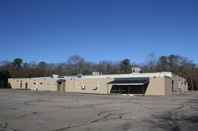
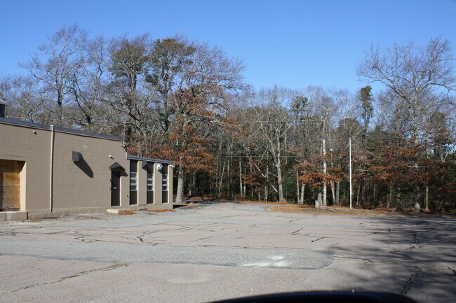
Property Record
250 Cherry St, Plymouth, MA 02360

Current Lease Availabilities
NEARBY LISTINGS FOR SALE OR LEASE
Property Detail
250 Cherry St
PLYM-000102-000000-000008A-000003
Plymouth
Manufacturinglight
Massachusetts
X
8a-3
25023C0354K
3.26 AC
2025
Route 3 South
2025
Boston
530100
Boston-Cambridge-Newton, MA-NH
25,175 SF
DEMOGRAPHICS near 250 Cherry St
1 Mile
3 Mile
5 Mile
2024 Total Population
2,485
30,310
51,370
2029 Population
2,524
30,628
51,740
Pop Growth 2024-2029
+ 1.57%
+ 1.05%
+ 0.72%
Average Age
42
43
43
2024 Total Households
1,022
12,460
20,155
HH Growth 2024-2029
+ 1.37%
+ 0.95%
+ 0.67%
Median Household Inc
$83,029
$95,216
$101,493
Avg Household Size
2.40
2.40
2.40
2024 Avg HH Vehicles
2.00
2.00
2.00
Median Home Value
$465,431
$452,683
$478,396
Median Year Built
1978
1973
1974
Nearby Places
Map Layers
Map Styles
 Street
 Aerial
- Restaurants
- Banks
- Shops
- Fitness
- Groceries
PUBLIC TRANSPORTATION
COMMUTER RAIL
Kingston/Route 3 (Kingston/Plymouth Line - Massachusetts Bay Transportation Authority Commuter Rail (Purple Line))
DRIVE
WALK
Distance
Kingston/Route 3 (Kingston/Plymouth Line - Massachusetts Bay Transportation Authority Commuter Rail (Purple Line))
7 min
2.1 mi
Freight Ports
Port of New Bedford Harbor
DRIVE
WALK
Distance
Port of New Bedford Harbor
49 min
32.2 mi
Nearby Properties
Address
Land Use
TOTAL SIZE
Lot Size
Zoning
Address
Land Use
TOTAL SIZE
Lot Size
Zoning
14.60 AC
MC
Address
Land Use
TOTAL SIZE
Lot Size
Zoning
24.64 AC
HC
Address
Land Use
TOTAL SIZE
Lot Size
Zoning
375,020 SF
10.07 AC
Address
Land Use
TOTAL SIZE
Lot Size
Zoning
90,790 SF
16.04 AC
Address
Land Use
TOTAL SIZE
Lot Size
Zoning
205,540 SF
8.16 AC
LI
Address
Land Use
TOTAL SIZE
Lot Size
Zoning
4.67 AC
LI
Address
Land Use
TOTAL SIZE
Lot Size
Zoning
26.16 AC
MC
Address
Land Use
TOTAL SIZE
Lot Size
Zoning
27.31 AC
MC
Address
Land Use
TOTAL SIZE
Lot Size
Zoning
69.81 AC
Address
Land Use
TOTAL SIZE
Lot Size
Zoning
18.38 AC
AC
Address
Land Use
TOTAL SIZE
Lot Size
Zoning
214,442 SF
21.50 AC
MC
Address
Land Use
TOTAL SIZE
Lot Size
Zoning
122,558 SF
17.44 AC
GC
Address
Land Use
TOTAL SIZE
Lot Size
Zoning
18.33 AC
LI
Address
Land Use
TOTAL SIZE
Lot Size
Zoning
233,971 SF
14.93 AC
R20M
Address
Land Use
TOTAL SIZE
Lot Size
Zoning
62,502 SF
0.92 AC
R20S
Address
Land Use
TOTAL SIZE
Lot Size
Zoning
12.71 AC
LI
Address
Land Use
TOTAL SIZE
Lot Size
Zoning
4.58 AC
R20M
Address
Land Use
TOTAL SIZE
Lot Size
Zoning
9.41 AC
MC
Address
Land Use
TOTAL SIZE
Lot Size
Zoning
16.30 AC
GC
Address
Land Use
TOTAL SIZE
Lot Size
Zoning
97,390 SF
16.25 AC
LI
Address
Land Use
TOTAL SIZE
Lot Size
Zoning
13.88 AC
LI
Address
Land Use
TOTAL SIZE
Lot Size
Zoning
3.13 AC
R20M
Address
Land Use
TOTAL SIZE
Lot Size
Zoning
96,598 SF
8.47 AC
R20M
Address
Land Use
TOTAL SIZE
Lot Size
Zoning
138,240 SF
16.70 AC
Address
Land Use
TOTAL SIZE
Lot Size
Zoning
89,568 SF
3.52 AC
R20S
Address
Land Use
TOTAL SIZE
Lot Size
Zoning
118,602 SF
10.49 AC
AC
Address
Land Use
TOTAL SIZE
Lot Size
Zoning
120,727 SF
30.61 AC
Address
Land Use
TOTAL SIZE
Lot Size
Zoning
79,560 SF
3.03 AC
R20M
Address
Land Use
TOTAL SIZE
Lot Size
Zoning
0.24 AC
R25
Address
Land Use
TOTAL SIZE
Lot Size
Zoning
110,760 SF
2.09 AC
MC
The World's #1 Commercial Real Estate Marketplace
Connect with us
© 2026 CoStar Group
The information above has been obtained from sources believed reliable. While we do not doubt its accuracy we have not verified it and make no guarantee, warranty or representation about it. It is your responsibility to independently confirm its accuracy and completeness. Any projections, opinions, assumptions, or estimates used are for example only and do not represent the current or future performance of the property. The value of this transaction to you depends on tax and other factors which should be evaluated by your tax, financial, and legal advisors. You and your advisors should conduct a careful, independent investigation of the property to determine to your satisfaction the suitability of the property for your needs.