Property Record
250 E 7Th St, Upland, CA 91786


Property Detail
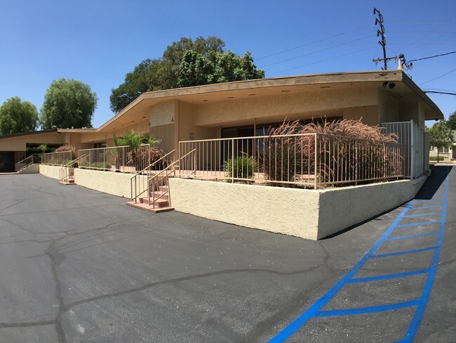
250 E 7Th St
1047-231-02
ONTARIO COLONY LANDS PTN LOT 689 COM AT A PT ON N LI SD LOT 689 WHICH PT IS 753.50 FT ELY FROM NW COR LOT 690 SD PT ALSO BEING THE MOST NLY PT ON THE ELY LI STATE HGWY TH S 43 DEG 34 MIN 35 SECONDS W 34.74 FT TH S 2 DEG 26 MIN 47 SECONDS E 114.50 FT
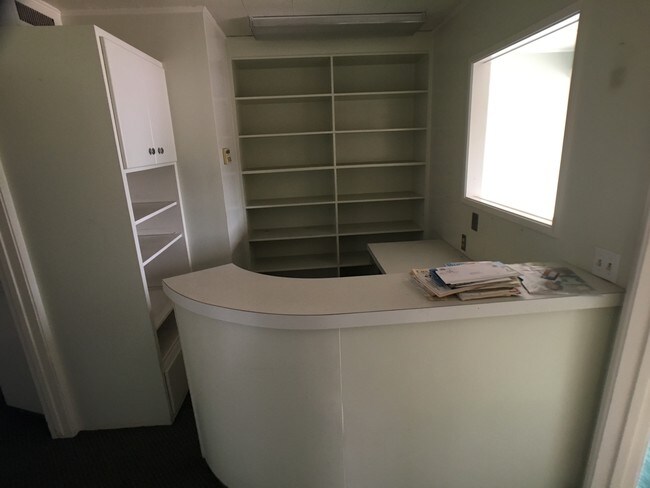
Medicalbuilding
San Bernardino
CP
California
B and X Area of moderate flood hazard, usually the area between the limits of the 100-year and 500-year floods.
689
2025
1.22 AC
2025
Upland/Montclair
000904
Inland Empire (California)
7,644 SF
Riverside-San Bernardino-Ontario, CA
NEARBY LISTINGS FOR SALE OR LEASE
DEMOGRAPHICS near 250 E 7Th St
1 mile
3 mile
5 mile
2025 Total Population
24,005
190,480
420,192
2030 Population
24,104
191,706
422,431
Pop Growth 2025-2030
+ 0.41%
+ 0.64%
+ 0.53%
Average Age
38
37
38
2025 Total Households
7,771
59,881
133,216
HH Growth 2025-2030
+ 0.48%
+ 0.72%
+ 0.59%
Median Household Inc
$83,885
$87,218
$94,228
Avg Household Size
3.00
3.10
3.00
2025 Avg HH Vehicles
2.00
2.00
2.00
Median Home Value
$684,929
$669,767
$703,304
Median Year Built
1962
1973
1976
Nearby Places
Map Layers
Map Styles
 Street
 Aerial
Transit
 Traffic
 Biking
Places
Listings with unknown addresses are not visible on the map
- Restaurants
- Banks
- Shops
- Fitness
- Groceries
PUBLIC TRANSPORTATION
COMMUTER RAIL
Upland (San Bernardino Line - Southern California Regional Rail Authority (Metrolink))
Drive
Walk
Distance
Upland (San Bernardino Line - Southern California Regional Rail Authority (Metrolink))
1 min
9 min
0.5 mi
Montclair (San Bernardino Line - Southern California Regional Rail Authority (Metrolink))
Drive
Walk
Distance
Montclair (San Bernardino Line - Southern California Regional Rail Authority (Metrolink))
8 min
3.4 mi
AIRPORT
Ontario International
Drive
Walk
Distance
Ontario International
12 min
8.2 mi
Freight Ports
Port of Long Beach
Drive
Walk
Distance
Port of Long Beach
1 min
38.0 mi
SALE & LEASE HISTORY
LISTING DATE
SALE/LEASE

Sep 01, 2017
For Lease
Oct 28, 2019
For Lease
Nearby Properties
Address
Land Use
TOTAL SIZE
Lot Size
Zoning
Address
Land Use
TOTAL SIZE
Lot Size
Zoning
376,610 SF
25.22 AC
Address
Land Use
TOTAL SIZE
Lot Size
Zoning
244,370 SF
59.72 AC
Address
Land Use
TOTAL SIZE
Lot Size
Zoning
539,128 SF
10.24 AC
Address
Land Use
TOTAL SIZE
Lot Size
Zoning
788,560 SF
36.86 AC
Address
Land Use
TOTAL SIZE
Lot Size
Zoning
1,052,840 SF
41.85 AC
Address
Land Use
TOTAL SIZE
Lot Size
Zoning
531,988 SF
9.83 AC
Address
Land Use
TOTAL SIZE
Lot Size
Zoning
167,512 SF
8.35 AC
Address
Land Use
TOTAL SIZE
Lot Size
Zoning
123,833 SF
11.23 AC
Address
Land Use
TOTAL SIZE
Lot Size
Zoning
573,220 SF
32.33 AC
Address
Land Use
TOTAL SIZE
Lot Size
Zoning
780,648 SF
13.59 AC
Address
Land Use
TOTAL SIZE
Lot Size
Zoning
553,882 SF
24.59 AC
Address
Land Use
TOTAL SIZE
Lot Size
Zoning
125,663 SF
7.04 AC
Address
Land Use
TOTAL SIZE
Lot Size
Zoning
218,376 SF
12.50 AC
Address
Land Use
TOTAL SIZE
Lot Size
Zoning
340,104 SF
8.95 AC
Address
Land Use
TOTAL SIZE
Lot Size
Zoning
250,200 SF
15.06 AC
Address
Land Use
TOTAL SIZE
Lot Size
Zoning
83,562 SF
10.06 AC
Address
Land Use
TOTAL SIZE
Lot Size
Zoning
249,672 SF
13.80 AC
Address
Land Use
TOTAL SIZE
Lot Size
Zoning
1.86 AC
Address
Land Use
TOTAL SIZE
Lot Size
Zoning
397,875 SF
14.13 AC
Address
Land Use
TOTAL SIZE
Lot Size
Zoning
175,000 SF
15.24 AC
Address
Land Use
TOTAL SIZE
Lot Size
Zoning
173,531 SF
2.52 AC
Address
Land Use
TOTAL SIZE
Lot Size
Zoning
504,530 SF
22.76 AC
Address
Land Use
TOTAL SIZE
Lot Size
Zoning
120,939 SF
3.87 AC
Address
Land Use
TOTAL SIZE
Lot Size
Zoning
180,868 SF
8.24 AC
Address
Land Use
TOTAL SIZE
Lot Size
Zoning
73,190 SF
5.43 AC
Address
Land Use
TOTAL SIZE
Lot Size
Zoning
106,212 SF
5.33 AC
Address
Land Use
TOTAL SIZE
Lot Size
Zoning
102,454 SF
7.70 AC
Address
Land Use
TOTAL SIZE
Lot Size
Zoning
129,480 SF
6.39 AC
Address
Land Use
TOTAL SIZE
Lot Size
Zoning
112,960 SF
6.30 AC
Address
Land Use
TOTAL SIZE
Lot Size
Zoning
161,555 SF
8.25 AC
The World's #1 Commercial Real Estate Marketplace
Connect with us
© 2026 CoStar Group
The information above has been obtained from sources believed reliable. While we do not doubt its accuracy we have not verified it and make no guarantee, warranty or representation about it. It is your responsibility to independently confirm its accuracy and completeness. Any projections, opinions, assumptions, or estimates used are for example only and do not represent the current or future performance of the property. The value of this transaction to you depends on tax and other factors which should be evaluated by your tax, financial, and legal advisors. You and your advisors should conduct a careful, independent investigation of the property to determine to your satisfaction the suitability of the property for your needs.