Property Record
250 E Debbie Ln, Mansfield, TX 76063
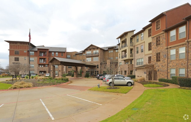

Property Detail
250 E Debbie Ln
Dallas-Fort Worth-Arlington, TX
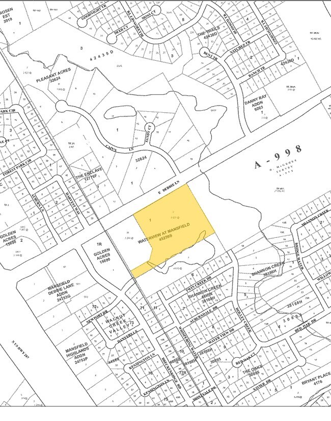
WATERVIEW AT MANSFIELD BLOCK 1 LOT 2
41462602
Tarrant
Multifamilydwelling
Texas
B and X Area of moderate flood hazard, usually the area between the limits of the 100-year and 500-year floods.
2
2024
8.62 AC
2025
South Fort Worth
111304
Dallas/Ft Worth
208,630 SF
NEARBY LISTINGS FOR SALE OR LEASE
DEMOGRAPHICS near 250 E Debbie Ln
1 mile
3 mile
5 mile
2025 Total Population
10,200
83,602
201,041
2030 Population
10,718
88,256
212,788
Pop Growth 2025-2030
+ 5.08%
+ 5.57%
+ 5.84%
Average Age
38
38
37
2025 Total Households
3,614
27,286
65,851
HH Growth 2025-2030
+ 5.51%
+ 5.86%
+ 6.01%
Median Household Inc
$101,936
$107,855
$104,795
Avg Household Size
2.80
3.00
3.00
2025 Avg HH Vehicles
2.00
2.00
2.00
Median Home Value
$388,508
$374,329
$368,975
Median Year Built
2001
2002
2001
Nearby Places
Map Layers
Map Styles
 Street
 Aerial
Layers
 Traffic
 Biking
Places
Listings with unknown addresses are not visible on the map
- Restaurants
- Banks
- Shops
- Fitness
- Groceries
PUBLIC TRANSPORTATION
AIRPORT
Dallas-Fort Worth International
Drive
Walk
Distance
Dallas-Fort Worth International
39 min
26.3 mi
Dallas Love Field
Drive
Walk
Distance
Dallas Love Field
49 min
34.9 mi
Freight Ports
Port of Shreveport
Drive
Walk
Distance
Port of Shreveport
240 min
220.6 mi
Nearby Properties
Address
Land Use
TOTAL SIZE
Lot Size
Zoning
Address
Land Use
TOTAL SIZE
Lot Size
Zoning
426,667 SF
12.87 AC
Address
Land Use
TOTAL SIZE
Lot Size
Zoning
348,951 SF
18.66 AC
Address
Land Use
TOTAL SIZE
Lot Size
Zoning
317,142 SF
11.40 AC
Address
Land Use
TOTAL SIZE
Lot Size
Zoning
160,000 SF
26.90 AC
Address
Land Use
TOTAL SIZE
Lot Size
Zoning
413,000 SF
19.16 AC
Address
Land Use
TOTAL SIZE
Lot Size
Zoning
298,988 SF
7.16 AC
Address
Land Use
TOTAL SIZE
Lot Size
Zoning
273,381 SF
8.32 AC
Address
Land Use
TOTAL SIZE
Lot Size
Zoning
276,467 SF
7.61 AC
Address
Land Use
TOTAL SIZE
Lot Size
Zoning
246,204 SF
15.16 AC
Address
Land Use
TOTAL SIZE
Lot Size
Zoning
249,922 SF
17.26 AC
Address
Land Use
TOTAL SIZE
Lot Size
Zoning
255,134 SF
21.62 AC
Address
Land Use
TOTAL SIZE
Lot Size
Zoning
170,082 SF
36.49 AC
Address
Land Use
TOTAL SIZE
Lot Size
Zoning
724,286 SF
48.41 AC
Address
Land Use
TOTAL SIZE
Lot Size
Zoning
231,551 SF
25.69 AC
Address
Land Use
TOTAL SIZE
Lot Size
Zoning
171,820 SF
59.63 AC
Address
Land Use
TOTAL SIZE
Lot Size
Zoning
98,664 SF
5.47 AC
Address
Land Use
TOTAL SIZE
Lot Size
Zoning
234,580 SF
65.82 AC
Address
Land Use
TOTAL SIZE
Lot Size
Zoning
229,168 SF
6.13 AC
Address
Land Use
TOTAL SIZE
Lot Size
Zoning
399,496 SF
23.29 AC
Address
Land Use
TOTAL SIZE
Lot Size
Zoning
318,000 SF
19.93 AC
Address
Land Use
TOTAL SIZE
Lot Size
Zoning
359,397 SF
17.31 AC
Address
Land Use
TOTAL SIZE
Lot Size
Zoning
149,494 SF
3.73 AC
Address
Land Use
TOTAL SIZE
Lot Size
Zoning
125,000 SF
18.37 AC
Address
Land Use
TOTAL SIZE
Lot Size
Zoning
663,733 SF
7.77 AC
Address
Land Use
TOTAL SIZE
Lot Size
Zoning
79,070 SF
11.98 AC
Address
Land Use
TOTAL SIZE
Lot Size
Zoning
92,456 SF
5.14 AC
Address
Land Use
TOTAL SIZE
Lot Size
Zoning
427,622 SF
24.26 AC
Address
Land Use
TOTAL SIZE
Lot Size
Zoning
84,237 SF
22.89 AC
Address
Land Use
TOTAL SIZE
Lot Size
Zoning
275,337 SF
14 AC
The World's #1 Commercial Real Estate Marketplace
Connect with us
© 2026 CoStar Group
The information above has been obtained from sources believed reliable. While we do not doubt its accuracy we have not verified it and make no guarantee, warranty or representation about it. It is your responsibility to independently confirm its accuracy and completeness. Any projections, opinions, assumptions, or estimates used are for example only and do not represent the current or future performance of the property. The value of this transaction to you depends on tax and other factors which should be evaluated by your tax, financial, and legal advisors. You and your advisors should conduct a careful, independent investigation of the property to determine to your satisfaction the suitability of the property for your needs.