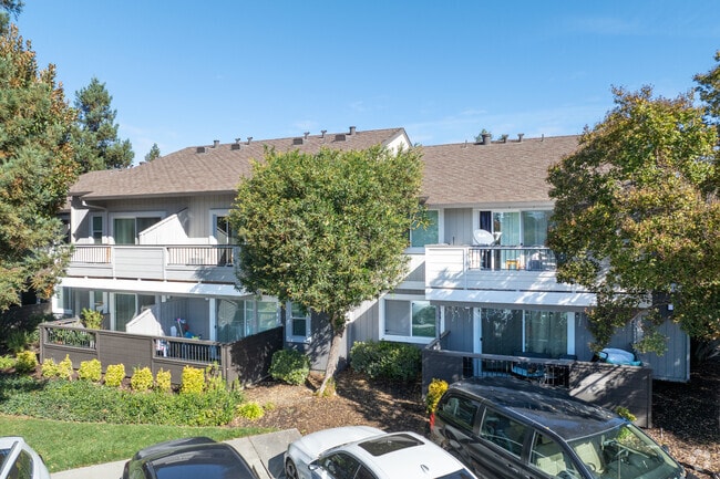
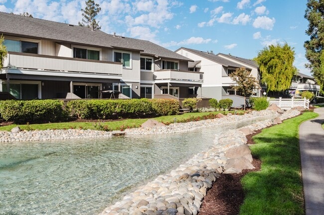
Property Record
250 Ellmar Oaks Ct, San Jose, CA 95136

NEARBY LISTINGS FOR SALE OR LEASE
-
-
View all San Jose listings for sale on LoopNet.com
Property Detail
250 Ellmar Oaks Ct
San Jose-Sunnyvale-Santa Clara, CA
Ellmar Oaks
462-42-002
TRACT 6981 BOOK 524 PAGE 28 PAGE 29 LOT 2
Multifamilydwelling
Santa Clara
D
California
06085C0263H
2
2024
15.07 AC
2025
Parkview
512019
South Bay/San Jose
241,800 SF
DEMOGRAPHICS near 250 Ellmar Oaks Ct
1 Mile
3 Mile
5 Mile
2024 Total Population
31,880
220,634
546,372
2029 Population
30,957
211,594
524,734
Pop Growth 2024-2029
(2.90%)
(4.10%)
(3.96%)
Average Age
39
40
40
2024 Total Households
11,109
70,296
174,039
HH Growth 2024-2029
(3.04%)
(4.30%)
(4.14%)
Median Household Inc
$114,993
$114,361
$123,285
Avg Household Size
2.80
3.00
3.00
2024 Avg HH Vehicles
2.00
2.00
2.00
Median Home Value
$903,001
$948,246
$1,042,736
Median Year Built
1983
1975
1974
Nearby Places
Map Layers
Map Styles
 Street
 Aerial
- Restaurants
- Banks
- Shops
- Fitness
- Groceries
PUBLIC TRANSPORTATION
TRANSIT/SUBWAY
Capitol Station (Alum Rock - Santa Teresa Line - Santa Clara VTA Light Rail)
DRIVE
WALK
Distance
Capitol Station (Alum Rock - Santa Teresa Line - Santa Clara VTA Light Rail)
2 min
20 min
1.0 mi
Capitol Station (Baypointe - Santa Teresa - VTA, Baypointe - Santa Teresa Modified-S - VTA)
DRIVE
WALK
Distance
Capitol Station (Baypointe - Santa Teresa - VTA, Baypointe - Santa Teresa Modified-S - VTA)
7 min
20 min
1.1 mi
COMMUTER RAIL
Capitol (Caltrain - Caltrain (Caltrain), South Santa Clara County Connector - Caltrain (Caltrain))
DRIVE
WALK
Distance
Capitol (Caltrain - Caltrain (Caltrain), South Santa Clara County Connector - Caltrain (Caltrain))
3 min
1.6 mi
Blossom Hill (Caltrain - Caltrain (Caltrain), South Santa Clara County Connector - Caltrain (Caltrain))
DRIVE
WALK
Distance
Blossom Hill (Caltrain - Caltrain (Caltrain), South Santa Clara County Connector - Caltrain (Caltrain))
6 min
3.4 mi
AIRPORT
Norman Y Mineta San Jose International
DRIVE
WALK
Distance
Norman Y Mineta San Jose International
15 min
9.4 mi
Freight Ports
Port of Redwood City
DRIVE
WALK
Distance
Port of Redwood City
36 min
28.6 mi
Nearby Properties
Address
Land Use
TOTAL SIZE
Lot Size
Zoning
Address
Land Use
TOTAL SIZE
Lot Size
Zoning
526,700 SF
29.03 AC
APD
Address
Land Use
TOTAL SIZE
Lot Size
Zoning
350,451 SF
4.69 AC
M1PD
Address
Land Use
TOTAL SIZE
Lot Size
Zoning
1.16 AC
R1BD
Address
Land Use
TOTAL SIZE
Lot Size
Zoning
414,727 SF
16.59 AC
PD
Address
Land Use
TOTAL SIZE
Lot Size
Zoning
323,496 SF
12.02 AC
R140
Address
Land Use
TOTAL SIZE
Lot Size
Zoning
212,532 SF
7.12 AC
APD
Address
Land Use
TOTAL SIZE
Lot Size
Zoning
0.13 AC
R1B6
Address
Land Use
TOTAL SIZE
Lot Size
Zoning
209,128 SF
13.13 AC
R1PD
Address
Land Use
TOTAL SIZE
Lot Size
Zoning
279,086 SF
10.74 AC
R3
Address
Land Use
TOTAL SIZE
Lot Size
Zoning
11.39 AC
A-PD
Address
Land Use
TOTAL SIZE
Lot Size
Zoning
5,000 SF
3.52 AC
CN
Address
Land Use
TOTAL SIZE
Lot Size
Zoning
8.72 AC
A-PD
Address
Land Use
TOTAL SIZE
Lot Size
Zoning
121,648 SF
5.80 AC
R1B6
Address
Land Use
TOTAL SIZE
Lot Size
Zoning
6.21 AC
APD
Address
Land Use
TOTAL SIZE
Lot Size
Zoning
358,320 SF
4.97 AC
R1-20
Address
Land Use
TOTAL SIZE
Lot Size
Zoning
155,286 SF
9.50 AC
R3
Address
Land Use
TOTAL SIZE
Lot Size
Zoning
275,000 SF
12.24 AC
A-PD
Address
Land Use
TOTAL SIZE
Lot Size
Zoning
20,150.53 AC
SJ
Address
Land Use
TOTAL SIZE
Lot Size
Zoning
6.24 AC
A-PD
Address
Land Use
TOTAL SIZE
Lot Size
Zoning
113.46 AC
M4
Address
Land Use
TOTAL SIZE
Lot Size
Zoning
216,589 SF
20.22 AC
C3
Address
Land Use
TOTAL SIZE
Lot Size
Zoning
21.67 AC
R3B
Address
Land Use
TOTAL SIZE
Lot Size
Zoning
163,904 SF
9.48 AC
R3APD
Address
Land Use
TOTAL SIZE
Lot Size
Zoning
5.05 AC
APD
Address
Land Use
TOTAL SIZE
Lot Size
Zoning
355,728 SF
20.95 AC
IP
Address
Land Use
TOTAL SIZE
Lot Size
Zoning
151,200 SF
5.82 AC
APD
Address
Land Use
TOTAL SIZE
Lot Size
Zoning
189,598 SF
2.20 AC
APD
Address
Land Use
TOTAL SIZE
Lot Size
Zoning
131,500 SF
20.54 AC
IPC
Address
Land Use
TOTAL SIZE
Lot Size
Zoning
450,000 SF
13.53 AC
HI
The World's #1 Commercial Real Estate Marketplace
Connect with us
© 2025 CoStar Group
The information above has been obtained from sources believed reliable. While we do not doubt its accuracy we have not verified it and make no guarantee, warranty or representation about it. It is your responsibility to independently confirm its accuracy and completeness. Any projections, opinions, assumptions, or estimates used are for example only and do not represent the current or future performance of the property. The value of this transaction to you depends on tax and other factors which should be evaluated by your tax, financial, and legal advisors. You and your advisors should conduct a careful, independent investigation of the property to determine to your satisfaction the suitability of the property for your needs.