Property Record
250 Epps Bridge Ln, Athens, GA 30606
NEARBY LISTINGS FOR SALE OR LEASE
Property Detail
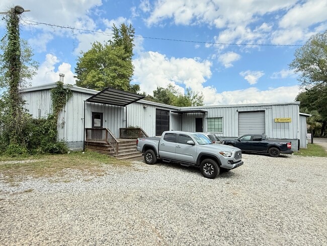
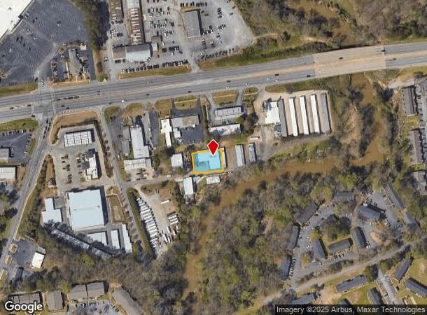
250 Epps Bridge Ln
121-023
Barks
Publicstorage
TRACT 1A & 2 - 0.309 AC
AE
Clarke
13059C0024F
Georgia
2025
0.31 AC
2025
Epps Bridge
150300
Other Market Areas
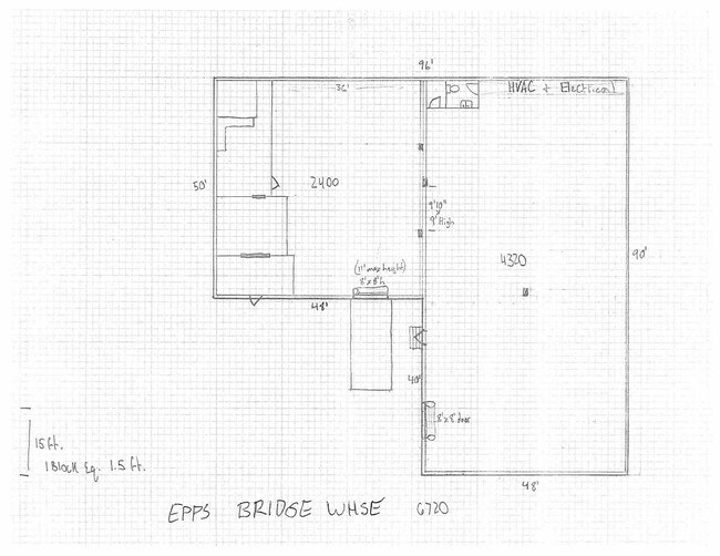
6,720 SF
Athens-Clarke County, GA
DEMOGRAPHICS near 250 Epps Bridge Ln
1 Mile
3 Mile
5 Mile
2024 Total Population
8,251
56,976
113,223
2029 Population
8,179
57,354
115,428
Pop Growth 2024-2029
(0.87%)
+ 0.66%
+ 1.95%
Average Age
38
36
35
2024 Total Households
3,848
23,167
44,311
HH Growth 2024-2029
(0.91%)
+ 0.64%
+ 1.79%
Median Household Inc
$51,044
$57,665
$53,092
Avg Household Size
2.00
2.10
2.30
2024 Avg HH Vehicles
1.00
2.00
2.00
Median Home Value
$286,005
$312,888
$287,166
Median Year Built
1986
1982
1988
Nearby Places
Map Layers
Map Styles
 Street
 Aerial
- Restaurants
- Banks
- Shops
- Fitness
- Groceries
SALE & LEASE HISTORY
LISTING DATE
SALE/LEASE

Oct 09, 2024
For Lease
Nearby Properties
Address
Land Use
TOTAL SIZE
Lot Size
Zoning
Address
Land Use
TOTAL SIZE
Lot Size
Zoning
11.36 AC
G
Address
Land Use
TOTAL SIZE
Lot Size
Zoning
21.57 AC
G
Address
Land Use
TOTAL SIZE
Lot Size
Zoning
49.33 AC
G
Address
Land Use
TOTAL SIZE
Lot Size
Zoning
24.70 AC
G
Address
Land Use
TOTAL SIZE
Lot Size
Zoning
163,904 SF
3.75 AC
C-D
Address
Land Use
TOTAL SIZE
Lot Size
Zoning
16.60 AC
G
Address
Land Use
TOTAL SIZE
Lot Size
Zoning
21.64 AC
G
Address
Land Use
TOTAL SIZE
Lot Size
Zoning
122,400 SF
12.51 AC
G
Address
Land Use
TOTAL SIZE
Lot Size
Zoning
85,608 SF
63.75 AC
RM-2
Address
Land Use
TOTAL SIZE
Lot Size
Zoning
8.38 AC
G
Address
Land Use
TOTAL SIZE
Lot Size
Zoning
87,066 SF
36.66 AC
RM-2
Address
Land Use
TOTAL SIZE
Lot Size
Zoning
212,919 SF
37.92 AC
RM-1
Address
Land Use
TOTAL SIZE
Lot Size
Zoning
81,792 SF
30.99 AC
RM-1
Address
Land Use
TOTAL SIZE
Lot Size
Zoning
184,293 SF
1.84 AC
C-D
Address
Land Use
TOTAL SIZE
Lot Size
Zoning
56.15 AC
G
Address
Land Use
TOTAL SIZE
Lot Size
Zoning
20 AC
G
Address
Land Use
TOTAL SIZE
Lot Size
Zoning
17.23 AC
G
Address
Land Use
TOTAL SIZE
Lot Size
Zoning
6.15 AC
G
Address
Land Use
TOTAL SIZE
Lot Size
Zoning
97,317 SF
24.31 AC
C-G
Address
Land Use
TOTAL SIZE
Lot Size
Zoning
81,973 SF
4.97 AC
G
Address
Land Use
TOTAL SIZE
Lot Size
Zoning
5,501 SF
1.47 AC
C-D
Address
Land Use
TOTAL SIZE
Lot Size
Zoning
4,907 SF
28.35 AC
RM-2
Address
Land Use
TOTAL SIZE
Lot Size
Zoning
17,388 SF
21.49 AC
RM-1
Address
Land Use
TOTAL SIZE
Lot Size
Zoning
18.47 AC
C-G
Address
Land Use
TOTAL SIZE
Lot Size
Zoning
112,071 SF
5.27 AC
E-O
Address
Land Use
TOTAL SIZE
Lot Size
Zoning
108,668 SF
37.79 AC
001
Address
Land Use
TOTAL SIZE
Lot Size
Zoning
66,200 SF
13.35 AC
G
Address
Land Use
TOTAL SIZE
Lot Size
Zoning
2,505 SF
25.03 AC
RM-1
Address
Land Use
TOTAL SIZE
Lot Size
Zoning
28.29 AC
G
Address
Land Use
TOTAL SIZE
Lot Size
Zoning
36.74 AC
G
The World's #1 Commercial Real Estate Marketplace
Connect with us
© 2025 CoStar Group
The information above has been obtained from sources believed reliable. While we do not doubt its accuracy we have not verified it and make no guarantee, warranty or representation about it. It is your responsibility to independently confirm its accuracy and completeness. Any projections, opinions, assumptions, or estimates used are for example only and do not represent the current or future performance of the property. The value of this transaction to you depends on tax and other factors which should be evaluated by your tax, financial, and legal advisors. You and your advisors should conduct a careful, independent investigation of the property to determine to your satisfaction the suitability of the property for your needs.