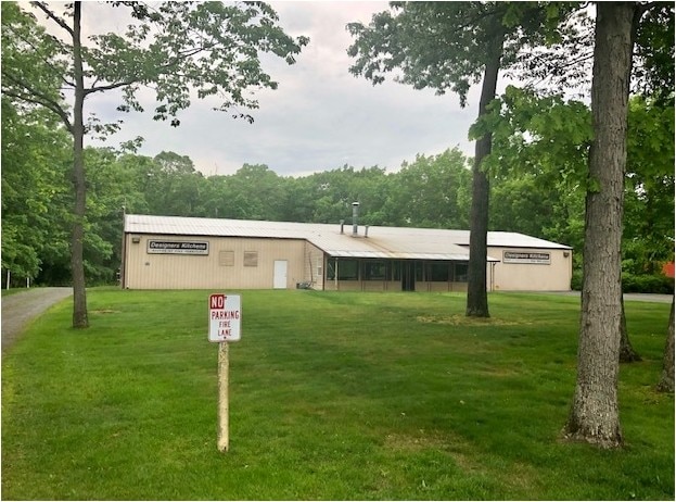
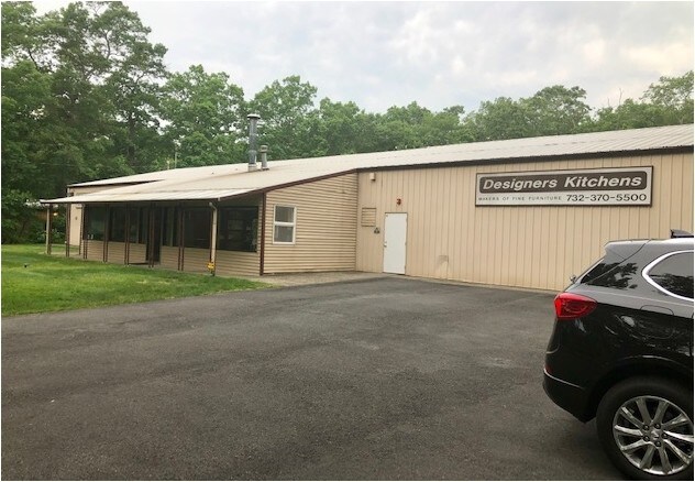
Property Record
250 Faraday Ave, Jackson, NJ 08527

NEARBY LISTINGS FOR SALE OR LEASE
Property Detail
250 Faraday Ave
Lakewood-New Brunswick, NJ
South Lakewood
12-22112-0000-00003
2.23 ACRES
Industrialgeneral
Ocean
X
New Jersey
34029C0167F
3
2024
2.23 AC
2025
Ocean County
717502
Northern New Jersey
DEMOGRAPHICS near 250 Faraday Ave
1 Mile
3 Mile
5 Mile
2024 Total Population
4,203
71,132
181,718
2029 Population
4,414
73,917
188,657
Pop Growth 2024-2029
+ 5.02%
+ 3.92%
+ 3.82%
Average Age
39
31
33
2024 Total Households
1,461
18,598
51,704
HH Growth 2024-2029
+ 4.59%
+ 3.14%
+ 3.09%
Median Household Inc
$76,910
$62,155
$60,873
Avg Household Size
2.70
3.40
3.10
2024 Avg HH Vehicles
2.00
2.00
2.00
Median Home Value
$363,417
$359,034
$332,398
Median Year Built
1997
1995
1988
Nearby Places
Map Layers
Map Styles
 Street
 Aerial
- Restaurants
- Banks
- Shops
- Fitness
- Groceries
SALE & LEASE HISTORY
LISTING DATE
SALE/LEASE

May 31, 2019
For Sale
Jun 24, 2020
For Lease
Nearby Properties
Address
Land Use
TOTAL SIZE
Lot Size
Zoning
Address
Land Use
TOTAL SIZE
Lot Size
Zoning
12.43 AC
HD7
Address
Land Use
TOTAL SIZE
Lot Size
Zoning
155.11 AC
PFE/
Address
Land Use
TOTAL SIZE
Lot Size
Zoning
17,952 SF
103.18 AC
PRA
Address
Land Use
TOTAL SIZE
Lot Size
Zoning
75,558 SF
43.30 AC
R15
Address
Land Use
TOTAL SIZE
Lot Size
Zoning
38.98 AC
R20C
Address
Land Use
TOTAL SIZE
Lot Size
Zoning
27.47 AC
R1
Address
Land Use
TOTAL SIZE
Lot Size
Zoning
12,269 SF
14.92 AC
R40C
Address
Land Use
TOTAL SIZE
Lot Size
Zoning
17,676 SF
7.25 AC
R15
Address
Land Use
TOTAL SIZE
Lot Size
Zoning
98,518 SF
12.71 AC
HC
Address
Land Use
TOTAL SIZE
Lot Size
Zoning
97,092 SF
15.97 AC
RHB
Address
Land Use
TOTAL SIZE
Lot Size
Zoning
15.17 AC
M1
Address
Land Use
TOTAL SIZE
Lot Size
Zoning
85,995 SF
7.60 AC
M1
Address
Land Use
TOTAL SIZE
Lot Size
Zoning
8.08 AC
HC
Address
Land Use
TOTAL SIZE
Lot Size
Zoning
39.28 AC
R12
Address
Land Use
TOTAL SIZE
Lot Size
Zoning
1,512 SF
411.32 AC
RD9
Address
Land Use
TOTAL SIZE
Lot Size
Zoning
93,712 SF
15.17 AC
M1
Address
Land Use
TOTAL SIZE
Lot Size
Zoning
19.11 AC
M1
Address
Land Use
TOTAL SIZE
Lot Size
Zoning
170,849 SF
12.89 AC
M1
Address
Land Use
TOTAL SIZE
Lot Size
Zoning
9.01 AC
M10A
Address
Land Use
TOTAL SIZE
Lot Size
Zoning
2,496 SF
2.63 AC
R20
Address
Land Use
TOTAL SIZE
Lot Size
Zoning
5,171 SF
4.34 AC
R20
Address
Land Use
TOTAL SIZE
Lot Size
Zoning
164.93 AC
PED+
Address
Land Use
TOTAL SIZE
Lot Size
Zoning
13.39 AC
R40C
Address
Land Use
TOTAL SIZE
Lot Size
Zoning
11,744 SF
9.98 AC
M10A
Address
Land Use
TOTAL SIZE
Lot Size
Zoning
68,864 SF
8.65 AC
RHB
Address
Land Use
TOTAL SIZE
Lot Size
Zoning
13,220 SF
11.59 AC
HD7
Address
Land Use
TOTAL SIZE
Lot Size
Zoning
6,000 SF
35.03 AC
M1
Address
Land Use
TOTAL SIZE
Lot Size
Zoning
72,940 SF
49.84 AC
SPLT
Address
Land Use
TOTAL SIZE
Lot Size
Zoning
6,527 SF
4.17 AC
R10A
Address
Land Use
TOTAL SIZE
Lot Size
Zoning
10.37 AC
M12A
The World's #1 Commercial Real Estate Marketplace
Connect with us
© 2026 CoStar Group
The information above has been obtained from sources believed reliable. While we do not doubt its accuracy we have not verified it and make no guarantee, warranty or representation about it. It is your responsibility to independently confirm its accuracy and completeness. Any projections, opinions, assumptions, or estimates used are for example only and do not represent the current or future performance of the property. The value of this transaction to you depends on tax and other factors which should be evaluated by your tax, financial, and legal advisors. You and your advisors should conduct a careful, independent investigation of the property to determine to your satisfaction the suitability of the property for your needs.