Property Record
250 Garfield Ave, Duluth, MN 55802


Save to a Folder
{{folder.Name}}
{{folder.ListingIds.length}} Properties
{{folder.ListingIds.length}} Property
Create a New Folder
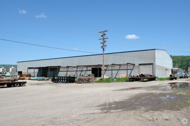
Property Detail
250 Garfield Ave
Duluth, MN-WI
ALL THAT PART OF LOTS 16 17 18 19 20 AND 21BLK F DULUTH PROPER 2ND DIV BEG AT A PT ONTHE S LINE OF LOT 21 BLK F 493.33 FT E OF ELINE OF GARFIELD AVE THENCE N 85 DEG 02'149.12 FT TO PT OF BEG THENCE CONTINUE NLY ONSAME LINE 179.45 FT THENCE ON A CURVE
010108000480
Saint Louis
Manufacturinglight
Minnesota
AE The base floodplain where base flood elevations are provided. AE Zones are now used on new format FIRMs instead of A1-A30 Zones.
16-21
2026
24.92 AC
2024
Lincoln Park/Garfield
015600
Duluth
5,392 SF
NEARBY LISTINGS FOR SALE OR LEASE
DEMOGRAPHICS near 250 Garfield Ave
1 mile
3 mile
5 mile
2025 Total Population
4,286
35,375
83,315
2030 Population
4,254
34,879
82,148
Pop Growth 2025-2030
(0.75%)
(1.40%)
(1.40%)
Average Age
38
39
39
2025 Total Households
2,204
16,719
35,487
HH Growth 2025-2030
(0.59%)
(1.50%)
(1.60%)
Median Household Inc
$36,411
$48,343
$58,748
Avg Household Size
1.80
1.90
2.10
2025 Avg HH Vehicles
1.00
1.00
2.00
Median Home Value
$164,218
$227,566
$245,789
Median Year Built
1949
1949
1952
Nearby Places
Map Layers
Map Styles
 Street
 Aerial
Layers
 Traffic
 Biking
Places
Listings with unknown addresses are not visible on the map
- Restaurants
- Banks
- Shops
- Fitness
- Groceries
PUBLIC TRANSPORTATION
AIRPORT
Duluth International
Drive
Walk
Distance
Duluth International
22 min
9.8 mi
Freight Ports
Port Milwaukee
Drive
Walk
Distance
Port Milwaukee
452 min
397.3 mi
Nearby Properties
Address
Land Use
TOTAL SIZE
Lot Size
Zoning
Address
Land Use
TOTAL SIZE
Lot Size
Zoning
539,170 SF
0.49 AC
Address
Land Use
TOTAL SIZE
Lot Size
Zoning
338,800 SF
0.17 AC
Address
Land Use
TOTAL SIZE
Lot Size
Zoning
547,975 SF
18.72 AC
Address
Land Use
TOTAL SIZE
Lot Size
Zoning
328,704 SF
3.81 AC
Address
Land Use
TOTAL SIZE
Lot Size
Zoning
391,335 SF
53.53 AC
Address
Land Use
TOTAL SIZE
Lot Size
Zoning
372,356 SF
1.35 AC
Address
Land Use
TOTAL SIZE
Lot Size
Zoning
175 AC
W1
Address
Land Use
TOTAL SIZE
Lot Size
Zoning
134,100 SF
0.17 AC
Address
Land Use
TOTAL SIZE
Lot Size
Zoning
195,455 SF
54.06 AC
Address
Land Use
TOTAL SIZE
Lot Size
Zoning
248,716 SF
1.02 AC
Address
Land Use
TOTAL SIZE
Lot Size
Zoning
40,835 SF
0.33 AC
Address
Land Use
TOTAL SIZE
Lot Size
Zoning
203,540 SF
0.24 AC
Address
Land Use
TOTAL SIZE
Lot Size
Zoning
97,552 SF
1.29 AC
Address
Land Use
TOTAL SIZE
Lot Size
Zoning
232,586 SF
0.16 AC
Address
Land Use
TOTAL SIZE
Lot Size
Zoning
178,184 SF
20 AC
Address
Land Use
TOTAL SIZE
Lot Size
Zoning
205,584 SF
0.81 AC
Address
Land Use
TOTAL SIZE
Lot Size
Zoning
178,104 SF
0.95 AC
Address
Land Use
TOTAL SIZE
Lot Size
Zoning
113,615 SF
0.32 AC
R4
Address
Land Use
TOTAL SIZE
Lot Size
Zoning
107,796 SF
9.19 AC
Address
Land Use
TOTAL SIZE
Lot Size
Zoning
175,168 SF
0.16 AC
Address
Land Use
TOTAL SIZE
Lot Size
Zoning
62,634 SF
4.32 AC
Address
Land Use
TOTAL SIZE
Lot Size
Zoning
144,760 SF
0.56 AC
C4
Address
Land Use
TOTAL SIZE
Lot Size
Zoning
68,296 SF
0.38 AC
Address
Land Use
TOTAL SIZE
Lot Size
Zoning
97,157 SF
1.61 AC
Address
Land Use
TOTAL SIZE
Lot Size
Zoning
144,408 SF
1.29 AC
Address
Land Use
TOTAL SIZE
Lot Size
Zoning
372,356 SF
1.15 AC
Address
Land Use
TOTAL SIZE
Lot Size
Zoning
72,980 SF
2.85 AC
R1B
Address
Land Use
TOTAL SIZE
Lot Size
Zoning
141,049 SF
0.50 AC
Address
Land Use
TOTAL SIZE
Lot Size
Zoning
8.50 AC
W1
The World's #1 Commercial Real Estate Marketplace
Connect with us
© 2026 CoStar Group
The information above has been obtained from sources believed reliable. While we do not doubt its accuracy we have not verified it and make no guarantee, warranty or representation about it. It is your responsibility to independently confirm its accuracy and completeness. Any projections, opinions, assumptions, or estimates used are for example only and do not represent the current or future performance of the property. The value of this transaction to you depends on tax and other factors which should be evaluated by your tax, financial, and legal advisors. You and your advisors should conduct a careful, independent investigation of the property to determine to your satisfaction the suitability of the property for your needs.