Property Record
250 Grant Pl, Lowell, AR 72745
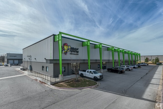

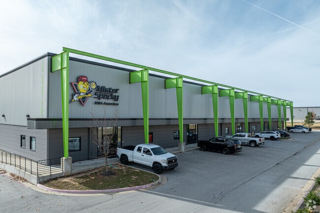
Property Detail
250 Grant Pl
Fayetteville-Springdale-Rogers, AR
REPLAT 3/28/2018 L201815587
12-03445-002
Benton
Industrialgeneral
Arkansas
B and X Area of moderate flood hazard, usually the area between the limits of the 100-year and 500-year floods.
7
2025
5.65 AC
2025
Outlying Benton County
021315
Fayetteville/Springdale/Rogers
49,800 SF
NEARBY LISTINGS FOR SALE OR LEASE
DEMOGRAPHICS near 250 Grant Pl
1 mile
3 mile
5 mile
2025 Total Population
1,192
32,511
102,847
2030 Population
1,306
35,970
112,563
Pop Growth 2025-2030
+ 9.56%
+ 10.64%
+ 9.45%
Average Age
37
35
36
2025 Total Households
445
11,264
34,329
HH Growth 2025-2030
+ 9.89%
+ 10.99%
+ 9.87%
Median Household Inc
$110,344
$116,106
$91,529
Avg Household Size
2.60
2.90
2.90
2025 Avg HH Vehicles
2.00
2.00
2.00
Median Home Value
$398,461
$411,850
$356,748
Median Year Built
2003
2007
2001
Nearby Places
Map Layers
Map Styles
 Street
 Aerial
Layers
 Traffic
 Biking
Places
Listings with unknown addresses are not visible on the map
- Restaurants
- Banks
- Shops
- Fitness
- Groceries
PUBLIC TRANSPORTATION
AIRPORT
Northwest Arkansas Ntl
Drive
Walk
Distance
Northwest Arkansas Ntl
24 min
11.0 mi
Freight Ports
Tulsa Port of Inola
Drive
Walk
Distance
Tulsa Port of Inola
106 min
90.8 mi
SALE & LEASE HISTORY
LISTING DATE
SALE/LEASE

Sep 27, 2017
For Lease
Sep 25, 2024
For Lease
Feb 21, 2024
For Lease
Aug 25, 2025
For Lease
Aug 25, 2025
For Lease
Nearby Properties
Address
Land Use
TOTAL SIZE
Lot Size
Zoning
Address
Land Use
TOTAL SIZE
Lot Size
Zoning
52,778 SF
1.04 AC
Address
Land Use
TOTAL SIZE
Lot Size
Zoning
367,076 SF
57.31 AC
Address
Land Use
TOTAL SIZE
Lot Size
Zoning
405,394 SF
10.97 AC
Address
Land Use
TOTAL SIZE
Lot Size
Zoning
412,893 SF
11.51 AC
Address
Land Use
TOTAL SIZE
Lot Size
Zoning
305,450 SF
12.16 AC
Address
Land Use
TOTAL SIZE
Lot Size
Zoning
365,674 SF
18.05 AC
Address
Land Use
TOTAL SIZE
Lot Size
Zoning
209,369 SF
21.60 AC
Address
Land Use
TOTAL SIZE
Lot Size
Zoning
251,508 SF
30 AC
Address
Land Use
TOTAL SIZE
Lot Size
Zoning
132,494 SF
21.56 AC
Address
Land Use
TOTAL SIZE
Lot Size
Zoning
306,148 SF
48.89 AC
Address
Land Use
TOTAL SIZE
Lot Size
Zoning
191,100 SF
10.03 AC
Address
Land Use
TOTAL SIZE
Lot Size
Zoning
20,878 SF
24.78 AC
Address
Land Use
TOTAL SIZE
Lot Size
Zoning
75,610 SF
5.62 AC
Address
Land Use
TOTAL SIZE
Lot Size
Zoning
249,393 SF
10.70 AC
Address
Land Use
TOTAL SIZE
Lot Size
Zoning
292,470 SF
17.27 AC
Address
Land Use
TOTAL SIZE
Lot Size
Zoning
67,152 SF
6.28 AC
Address
Land Use
TOTAL SIZE
Lot Size
Zoning
348,916 SF
24.69 AC
Address
Land Use
TOTAL SIZE
Lot Size
Zoning
29,670 SF
5.80 AC
Address
Land Use
TOTAL SIZE
Lot Size
Zoning
127,043 SF
6.82 AC
Address
Land Use
TOTAL SIZE
Lot Size
Zoning
53,503 SF
6.88 AC
Address
Land Use
TOTAL SIZE
Lot Size
Zoning
12,882 SF
12.33 AC
Address
Land Use
TOTAL SIZE
Lot Size
Zoning
39,793 SF
4.94 AC
Address
Land Use
TOTAL SIZE
Lot Size
Zoning
182,415 SF
68.93 AC
Address
Land Use
TOTAL SIZE
Lot Size
Zoning
182,415 SF
12.04 AC
Address
Land Use
TOTAL SIZE
Lot Size
Zoning
39,000 SF
16.38 AC
Address
Land Use
TOTAL SIZE
Lot Size
Zoning
73,711 SF
3.59 AC
Address
Land Use
TOTAL SIZE
Lot Size
Zoning
61,012 SF
18.96 AC
Address
Land Use
TOTAL SIZE
Lot Size
Zoning
123,740 SF
13.96 AC
Address
Land Use
TOTAL SIZE
Lot Size
Zoning
170,442 SF
12.62 AC
Address
Land Use
TOTAL SIZE
Lot Size
Zoning
160,570 SF
20.31 AC
The World's #1 Commercial Real Estate Marketplace
Connect with us
© 2026 CoStar Group
The information above has been obtained from sources believed reliable. While we do not doubt its accuracy we have not verified it and make no guarantee, warranty or representation about it. It is your responsibility to independently confirm its accuracy and completeness. Any projections, opinions, assumptions, or estimates used are for example only and do not represent the current or future performance of the property. The value of this transaction to you depends on tax and other factors which should be evaluated by your tax, financial, and legal advisors. You and your advisors should conduct a careful, independent investigation of the property to determine to your satisfaction the suitability of the property for your needs.