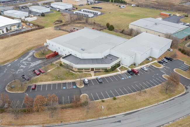
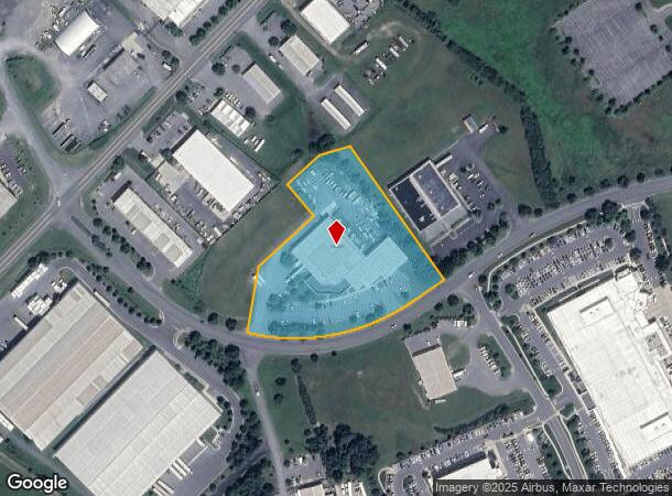
Property Record
250 Independence Rd, Winchester, VA 22602
NEARBY LISTINGS FOR SALE OR LEASE
-
-
View all Winchester listings for lease on LoopNet.com
Property Detail
250 Independence Rd
64A-159M
4
Multipleuses
3.72 ACRES
X
Frederick
51069C0219E
Virginia
2025
3.72 AC
2025
Frederick County VA
050900
Washington, DC
35,856 SF
Winchester, VA-WV
DEMOGRAPHICS near 250 Independence Rd
1 Mile
3 Mile
5 Mile
2024 Total Population
371
23,910
73,243
2029 Population
427
26,071
77,559
Pop Growth 2024-2029
+ 15.09%
+ 9.04%
+ 5.89%
Average Age
39
38
39
2024 Total Households
137
8,567
27,447
HH Growth 2024-2029
+ 14.60%
+ 9.06%
+ 5.55%
Median Household Inc
$53,000
$79,237
$73,702
Avg Household Size
2.60
2.70
2.60
2024 Avg HH Vehicles
2.00
2.00
2.00
Median Home Value
$335,000
$312,200
$310,201
Median Year Built
1997
1991
1986
Nearby Places
Map Layers
Map Styles
 Street
 Aerial
- Restaurants
- Banks
- Shops
- Fitness
- Groceries
SALE & LEASE HISTORY
LISTING DATE
SALE/LEASE

Jul 23, 2024
For Lease
Dec 13, 2022
For Lease
Nearby Properties
Address
Land Use
TOTAL SIZE
Lot Size
Zoning
Address
Land Use
TOTAL SIZE
Lot Size
Zoning
64.27 AC
M1
Address
Land Use
TOTAL SIZE
Lot Size
Zoning
56,582 SF
35.39 AC
M1
Address
Land Use
TOTAL SIZE
Lot Size
Zoning
31,710 SF
47.28 AC
HE1
Address
Land Use
TOTAL SIZE
Lot Size
Zoning
156,379 SF
55.53 AC
RA
Address
Land Use
TOTAL SIZE
Lot Size
Zoning
1,440 SF
6.73 AC
RA
Address
Land Use
TOTAL SIZE
Lot Size
Zoning
30,054 SF
62.32 AC
M2
Address
Land Use
TOTAL SIZE
Lot Size
Zoning
225,042 SF
56.33 AC
B2
Address
Land Use
TOTAL SIZE
Lot Size
Zoning
15.24 AC
RP
Address
Land Use
TOTAL SIZE
Lot Size
Zoning
462,500 SF
53.51 AC
B2
Address
Land Use
TOTAL SIZE
Lot Size
Zoning
422,658 SF
64.27 AC
M1
Address
Land Use
TOTAL SIZE
Lot Size
Zoning
100,465 SF
15.24 AC
RP
Address
Land Use
TOTAL SIZE
Lot Size
Zoning
231,756 SF
23.66 AC
CM1
Address
Land Use
TOTAL SIZE
Lot Size
Zoning
151,711 SF
16.25 AC
CM1
Address
Land Use
TOTAL SIZE
Lot Size
Zoning
181,832 SF
17.96 AC
CM1
Address
Land Use
TOTAL SIZE
Lot Size
Zoning
153,024 SF
33.47 AC
EIP
Address
Land Use
TOTAL SIZE
Lot Size
Zoning
64,711 SF
18.10 AC
B2
Address
Land Use
TOTAL SIZE
Lot Size
Zoning
2,310 SF
17.28 AC
RP
Address
Land Use
TOTAL SIZE
Lot Size
Zoning
94,606 SF
4.92 AC
B2
Address
Land Use
TOTAL SIZE
Lot Size
Zoning
87,000 SF
16.30 AC
EIP
Address
Land Use
TOTAL SIZE
Lot Size
Zoning
83,786 SF
2.71 AC
HE1
Address
Land Use
TOTAL SIZE
Lot Size
Zoning
43,232 SF
169.19 AC
EIP
Address
Land Use
TOTAL SIZE
Lot Size
Zoning
12,000 SF
8.78 AC
CM1
Address
Land Use
TOTAL SIZE
Lot Size
Zoning
97,168 SF
16.78 AC
B2
Address
Land Use
TOTAL SIZE
Lot Size
Zoning
71,607 SF
14.97 AC
RA
Address
Land Use
TOTAL SIZE
Lot Size
Zoning
77,484 SF
22.18 AC
HEB2
Address
Land Use
TOTAL SIZE
Lot Size
Zoning
51,550 SF
2.12 AC
EIP
Address
Land Use
TOTAL SIZE
Lot Size
Zoning
150,000 SF
10.37 AC
M1
Address
Land Use
TOTAL SIZE
Lot Size
Zoning
169,744 SF
9.68 AC
HR
Address
Land Use
TOTAL SIZE
Lot Size
Zoning
139,911 SF
14.46 AC
CM1
Address
Land Use
TOTAL SIZE
Lot Size
Zoning
60,377 SF
12.93 AC
R4
The World's #1 Commercial Real Estate Marketplace
Connect with us
© 2026 CoStar Group
The information above has been obtained from sources believed reliable. While we do not doubt its accuracy we have not verified it and make no guarantee, warranty or representation about it. It is your responsibility to independently confirm its accuracy and completeness. Any projections, opinions, assumptions, or estimates used are for example only and do not represent the current or future performance of the property. The value of this transaction to you depends on tax and other factors which should be evaluated by your tax, financial, and legal advisors. You and your advisors should conduct a careful, independent investigation of the property to determine to your satisfaction the suitability of the property for your needs.