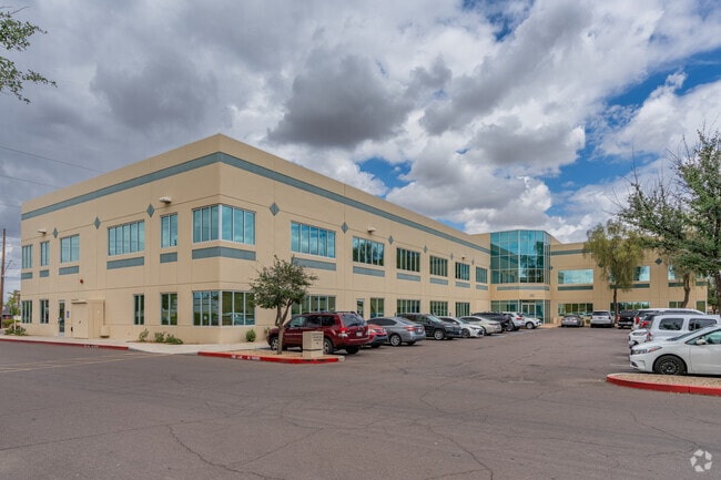
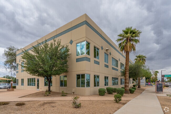
Property Record
250 N Litchfield Rd, Goodyear, AZ 85338

Save to a Folder
{{folder.Name}}
{{folder.ListingIds.length}} Properties
{{folder.ListingIds.length}} Property
Create a New Folder
Property Detail
250 N Litchfield Rd
500-04-016F
N 527F OF E 680F OF NE4 SEC 9 EX E 65F & EX N 40F & EX S 30F OF N 70F OF W 16F & EX S 33F OF N 73F OF W 25F OF E 413F SD NE4 & EX THAT PRT DAF BAP 65F W & 40F S OF NE COR SD SEC TH S 10F TH N 44D 35M W 14.16F TO SLY R/W LN VAN BUREN ST TH E 10F TO PO
Officebuilding
Maricopa
C-G
Arizona
C and X Area of minimal flood hazard, usually depicted on FIRMs as above the 500-year flood level.
3.83 AC
2025
West I-10
2025
Phoenix
061300
Phoenix-Mesa-Chandler, AZ
45,800 SF
NEARBY LISTINGS FOR SALE OR LEASE
DEMOGRAPHICS near 250 N Litchfield Rd
1 mile
3 mile
5 mile
2025 Total Population
7,678
89,309
206,289
2030 Population
7,975
93,429
216,796
Pop Growth 2025-2030
+ 3.87%
+ 4.61%
+ 5.09%
Average Age
35
37
37
2025 Total Households
2,426
29,505
66,642
HH Growth 2025-2030
+ 3.92%
+ 4.68%
+ 5.20%
Median Household Inc
$53,545
$85,317
$95,762
Avg Household Size
3.00
3.00
3.00
2025 Avg HH Vehicles
2.00
2.00
2.00
Median Home Value
$285,891
$429,061
$452,979
Median Year Built
1981
2003
2005
Nearby Places
Map Layers
Map Styles
 Street
 Aerial
Layers
 Traffic
 Biking
Places
Listings with unknown addresses are not visible on the map
- Restaurants
- Banks
- Shops
- Fitness
- Groceries
PUBLIC TRANSPORTATION
AIRPORT
Phoenix Sky Harbor International
Drive
Walk
Distance
Phoenix Sky Harbor International
31 min
23.2 mi
SALE & LEASE HISTORY
LISTING DATE
SALE/LEASE

Sep 25, 2016
For Lease
Sep 25, 2016
For Lease
Jun 21, 2021
For Lease
Jun 02, 2023
For Lease
Jan 17, 2024
For Lease
Dec 15, 2023
For Lease
Apr 20, 2023
For Lease
Apr 15, 2024
For Lease
Nearby Properties
Address
Land Use
TOTAL SIZE
Lot Size
Zoning
Address
Land Use
TOTAL SIZE
Lot Size
Zoning
15.76 AC
Address
Land Use
TOTAL SIZE
Lot Size
Zoning
16.70 AC
Address
Land Use
TOTAL SIZE
Lot Size
Zoning
15.76 AC
Address
Land Use
TOTAL SIZE
Lot Size
Zoning
76,301 SF
15.91 AC
Address
Land Use
TOTAL SIZE
Lot Size
Zoning
49,475 SF
5.70 AC
PAD
Address
Land Use
TOTAL SIZE
Lot Size
Zoning
370,726 SF
23.41 AC
PAD
Address
Land Use
TOTAL SIZE
Lot Size
Zoning
324,374 SF
18.26 AC
PAD
Address
Land Use
TOTAL SIZE
Lot Size
Zoning
487,354 SF
188.22 AC
PAD
Address
Land Use
TOTAL SIZE
Lot Size
Zoning
90,008 SF
20.42 AC
M-H
Address
Land Use
TOTAL SIZE
Lot Size
Zoning
2.51 AC
Address
Land Use
TOTAL SIZE
Lot Size
Zoning
418,000 SF
23.58 AC
I-1
Address
Land Use
TOTAL SIZE
Lot Size
Zoning
563,328 SF
24.43 AC
C2
Address
Land Use
TOTAL SIZE
Lot Size
Zoning
401,714 SF
100.01 AC
PAD
Address
Land Use
TOTAL SIZE
Lot Size
Zoning
901,699 SF
49.92 AC
I1
Address
Land Use
TOTAL SIZE
Lot Size
Zoning
220,494 SF
50.53 AC
AG
Address
Land Use
TOTAL SIZE
Lot Size
Zoning
855,336 SF
45.11 AC
Address
Land Use
TOTAL SIZE
Lot Size
Zoning
802,671 SF
48.81 AC
I1
Address
Land Use
TOTAL SIZE
Lot Size
Zoning
320,888 SF
31.41 AC
C-G
Address
Land Use
TOTAL SIZE
Lot Size
Zoning
398,872 SF
9.39 AC
PAD
Address
Land Use
TOTAL SIZE
Lot Size
Zoning
369,413 SF
16.39 AC
THEBLVDD
Address
Land Use
TOTAL SIZE
Lot Size
Zoning
790,980 SF
42.95 AC
I1
Address
Land Use
TOTAL SIZE
Lot Size
Zoning
222,900 SF
15.99 AC
Address
Land Use
TOTAL SIZE
Lot Size
Zoning
16.70 AC
Address
Land Use
TOTAL SIZE
Lot Size
Zoning
16.70 AC
Address
Land Use
TOTAL SIZE
Lot Size
Zoning
355,597 SF
14.83 AC
PAD
Address
Land Use
TOTAL SIZE
Lot Size
Zoning
295,635 SF
16.57 AC
PAD
Address
Land Use
TOTAL SIZE
Lot Size
Zoning
293,849 SF
33.20 AC
PAD
Address
Land Use
TOTAL SIZE
Lot Size
Zoning
663,150 SF
34.49 AC
Address
Land Use
TOTAL SIZE
Lot Size
Zoning
450,619 SF
28.95 AC
I2
The World's #1 Commercial Real Estate Marketplace
Connect with us
© 2026 CoStar Group
The information above has been obtained from sources believed reliable. While we do not doubt its accuracy we have not verified it and make no guarantee, warranty or representation about it. It is your responsibility to independently confirm its accuracy and completeness. Any projections, opinions, assumptions, or estimates used are for example only and do not represent the current or future performance of the property. The value of this transaction to you depends on tax and other factors which should be evaluated by your tax, financial, and legal advisors. You and your advisors should conduct a careful, independent investigation of the property to determine to your satisfaction the suitability of the property for your needs.