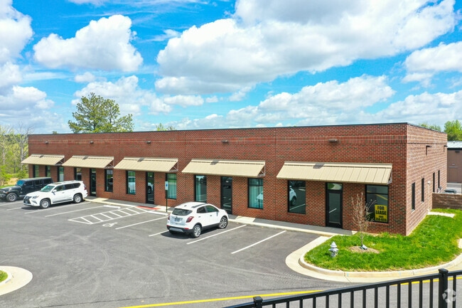
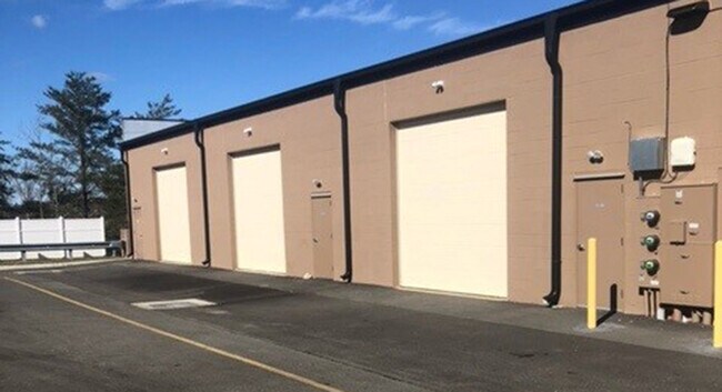
Property Record
250 N Otterdale Rd, Midlothian, VA 23113
NEARBY LISTINGS FOR SALE OR LEASE
-
-
View all Midlothian listings for lease on LoopNet.com
Property Detail
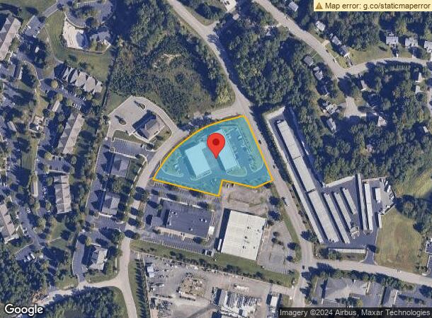
250 N Otterdale Rd
721-71-13-40-000-000
Otterdale Rd & Wylderose Dr
Commercialnec
OTTERDALE RD & WYLDEROSE DR
X
Chesterfield
51145C0170C
Virginia
2025
2.51 AC
2025
Midlothian Corridor
100924
Richmond VA
8,750 SF
Richmond, VA
DEMOGRAPHICS near 250 N Otterdale Rd
1 Mile
3 Mile
5 Mile
2024 Total Population
6,531
34,113
82,205
2029 Population
7,271
37,705
90,421
Pop Growth 2024-2029
+ 11.33%
+ 10.53%
+ 9.99%
Average Age
40
42
41
2024 Total Households
2,535
12,872
30,870
HH Growth 2024-2029
+ 11.44%
+ 10.69%
+ 10.05%
Median Household Inc
$99,794
$114,221
$117,305
Avg Household Size
2.60
2.60
2.60
2024 Avg HH Vehicles
2.00
2.00
2.00
Median Home Value
$452,429
$444,381
$398,010
Median Year Built
2005
2001
1995
Nearby Places
- Restaurants
- Banks
- Shops
- Fitness
- Groceries
PUBLIC TRANSPORTATION
AIRPORT
Richmond International
DRIVE
WALK
Distance
Richmond International
42 min
26.7 mi
Freight Ports
Virginia Port Authority - Richmond
DRIVE
WALK
Distance
Virginia Port Authority - Richmond
32 min
16.8 mi
SALE & LEASE HISTORY
LISTING DATE
SALE/LEASE

Sep 25, 2016
For Lease
Mar 20, 2017
For Sale
Mar 16, 2022
For Lease
Jan 09, 2019
For Lease
Feb 19, 2020
For Sale
Feb 13, 2019
For Lease
Aug 14, 2018
For Lease
Nearby Properties
Address
Land Use
TOTAL SIZE
Lot Size
Zoning
Address
Land Use
TOTAL SIZE
Lot Size
Zoning
578,400 SF
6.77 AC
I2 - GEN I
Address
Land Use
TOTAL SIZE
Lot Size
Zoning
5,720 SF
117.22 AC
R9 - SINGL
Address
Land Use
TOTAL SIZE
Lot Size
Zoning
332,521 SF
77.65 AC
I2 - GEN I
Address
Land Use
TOTAL SIZE
Lot Size
Zoning
112,053 SF
44.11 AC
R9 - SINGL
Address
Land Use
TOTAL SIZE
Lot Size
Zoning
5,922 SF
17.83 AC
RMF - RES,
Address
Land Use
TOTAL SIZE
Lot Size
Zoning
100 SF
4.46 AC
I2 - GEN I
Address
Land Use
TOTAL SIZE
Lot Size
Zoning
100 SF
17.82 AC
R7 - SINGL
Address
Land Use
TOTAL SIZE
Lot Size
Zoning
123,252 SF
48.88 AC
R7 - SINGL
Address
Land Use
TOTAL SIZE
Lot Size
Zoning
161,600 SF
18.40 AC
R7 - SINGL
Address
Land Use
TOTAL SIZE
Lot Size
Zoning
108,805 SF
21.09 AC
RMF - RES,
Address
Land Use
TOTAL SIZE
Lot Size
Zoning
100 SF
8.12 AC
C3 - COMMU
Address
Land Use
TOTAL SIZE
Lot Size
Zoning
241,433 SF
68.39 AC
R15 - SING
Address
Land Use
TOTAL SIZE
Lot Size
Zoning
163,704 SF
10.16 AC
I2 - GEN I
Address
Land Use
TOTAL SIZE
Lot Size
Zoning
72,417 SF
11.76 AC
R7 - SINGL
Address
Land Use
TOTAL SIZE
Lot Size
Zoning
89,300 SF
32.90 AC
O2 - CORP
Address
Land Use
TOTAL SIZE
Lot Size
Zoning
77,008 SF
8.55 AC
I2 - GEN I
Address
Land Use
TOTAL SIZE
Lot Size
Zoning
174,840 SF
21.13 AC
R7 - SINGL
Address
Land Use
TOTAL SIZE
Lot Size
Zoning
99,934 SF
81.69 AC
A - AGRICU
Address
Land Use
TOTAL SIZE
Lot Size
Zoning
62,636 SF
9.14 AC
RMF - RES,
Address
Land Use
TOTAL SIZE
Lot Size
Zoning
206,183 SF
25.21 AC
C3 - COMMU
Address
Land Use
TOTAL SIZE
Lot Size
Zoning
4.45 AC
RMF - RES,
Address
Land Use
TOTAL SIZE
Lot Size
Zoning
49,510 SF
8.86 AC
C3 - COMMU
Address
Land Use
TOTAL SIZE
Lot Size
Zoning
5,680 SF
6.75 AC
C2 - NBHD
Address
Land Use
TOTAL SIZE
Lot Size
Zoning
310.29 AC
C3 - COMMU
Address
Land Use
TOTAL SIZE
Lot Size
Zoning
132,360 SF
14.76 AC
I2 - GEN I
Address
Land Use
TOTAL SIZE
Lot Size
Zoning
111,778 SF
9.23 AC
C3 - COMMU
Address
Land Use
TOTAL SIZE
Lot Size
Zoning
139,484 SF
15.10 AC
C3 - COMMU
Address
Land Use
TOTAL SIZE
Lot Size
Zoning
93,925 SF
21.04 AC
A - AGRICU
Address
Land Use
TOTAL SIZE
Lot Size
Zoning
21,211 SF
3.53 AC
R7 - SINGL
Address
Land Use
TOTAL SIZE
Lot Size
Zoning
33,817 SF
1.71 AC
I1 - LT IN
The World's #1 Commercial Real Estate Marketplace
Connect with us
© 2025 CoStar Group
The information above has been obtained from sources believed reliable. While we do not doubt its accuracy we have not verified it and make no guarantee, warranty or representation about it. It is your responsibility to independently confirm its accuracy and completeness. Any projections, opinions, assumptions, or estimates used are for example only and do not represent the current or future performance of the property. The value of this transaction to you depends on tax and other factors which should be evaluated by your tax, financial, and legal advisors. You and your advisors should conduct a careful, independent investigation of the property to determine to your satisfaction the suitability of the property for your needs.