Property Record
250 Old Hook Rd, Westwood, NJ 07675


Save to a Folder
{{folder.Name}}
{{folder.ListingIds.length}} Properties
{{folder.ListingIds.length}} Property
Create a New Folder
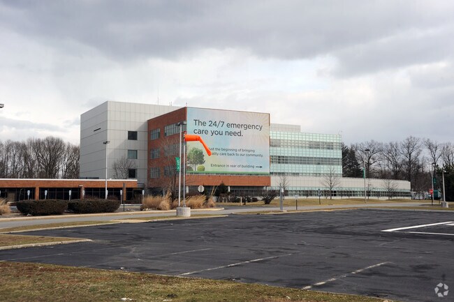
Current Lease Availabilities
Property Detail
250 Old Hook Rd
New York-Jersey City-White Plains, NY-NJ
48052SF
67-02001-0000-00016
Bergen
Commercialnec
New Jersey
HSO
65
B and X Area of moderate flood hazard, usually the area between the limits of the 100-year and 500-year floods.
19.96 AC
2025
North Central Bergen
2026
Northern New Jersey
059100
NEARBY LISTINGS FOR SALE OR LEASE
-
-
View all Westwood listings for lease on LoopNet.com
DEMOGRAPHICS near 250 Old Hook Rd
1 mile
3 mile
5 mile
2025 Total Population
12,145
92,424
268,948
2030 Population
12,559
95,769
278,481
Pop Growth 2025-2030
+ 3.41%
+ 3.62%
+ 3.54%
Average Age
42
43
43
2025 Total Households
4,478
32,153
91,584
HH Growth 2025-2030
+ 3.39%
+ 3.59%
+ 3.56%
Median Household Inc
$157,126
$162,828
$153,024
Avg Household Size
2.60
2.80
2.90
2025 Avg HH Vehicles
2.00
2.00
2.00
Median Home Value
$687,309
$721,117
$729,788
Median Year Built
1960
1958
1958
Nearby Places
Map Layers
Map Styles
 Street
 Aerial
Layers
 Traffic
 Biking
Places
Listings with unknown addresses are not visible on the map
- Restaurants
- Banks
- Shops
- Fitness
- Groceries
PUBLIC TRANSPORTATION
COMMUTER RAIL
Westwood (Pascack Valley Line - NJ Transit Commuter Rail (NJ Transit))
Drive
Walk
Distance
Westwood (Pascack Valley Line - NJ Transit Commuter Rail (NJ Transit))
2 min
1.3 mi
Emerson (Pascack Valley Line - NJ Transit Commuter Rail (NJ Transit))
Drive
Walk
Distance
Emerson (Pascack Valley Line - NJ Transit Commuter Rail (NJ Transit))
3 min
1.6 mi
AIRPORT
LaGuardia
Drive
Walk
Distance
LaGuardia
38 min
23.0 mi
Newark Liberty International
Drive
Walk
Distance
Newark Liberty International
33 min
25.6 mi
Westchester County
Drive
Walk
Distance
Westchester County
44 min
28.9 mi
Freight Ports
NY - Red Hook Container Terminal
Drive
Walk
Distance
NY - Red Hook Container Terminal
47 min
27.8 mi
Nearby Properties
Address
Land Use
TOTAL SIZE
Lot Size
Zoning
Address
Land Use
TOTAL SIZE
Lot Size
Zoning
59 AC
AA
Address
Land Use
TOTAL SIZE
Lot Size
Zoning
8.78 AC
HSO
Address
Land Use
TOTAL SIZE
Lot Size
Zoning
185,878 SF
33.44 AC
B
Address
Land Use
TOTAL SIZE
Lot Size
Zoning
23,572 SF
98.75 AC
CR
Address
Land Use
TOTAL SIZE
Lot Size
Zoning
9.20 AC
OR
Address
Land Use
TOTAL SIZE
Lot Size
Zoning
47,623 SF
88.60 AC
B
Address
Land Use
TOTAL SIZE
Lot Size
Zoning
191,950 SF
43.03 AC
RA25
Address
Land Use
TOTAL SIZE
Lot Size
Zoning
845.02 AC
Address
Land Use
TOTAL SIZE
Lot Size
Zoning
82.73 AC
Address
Land Use
TOTAL SIZE
Lot Size
Zoning
21.74 AC
SC
Address
Land Use
TOTAL SIZE
Lot Size
Zoning
0.78 AC
B
Address
Land Use
TOTAL SIZE
Lot Size
Zoning
Address
Land Use
TOTAL SIZE
Lot Size
Zoning
57,890 SF
26.61 AC
R100
Address
Land Use
TOTAL SIZE
Lot Size
Zoning
8.72 AC
A
Address
Land Use
TOTAL SIZE
Lot Size
Zoning
9.70 AC
Address
Land Use
TOTAL SIZE
Lot Size
Zoning
58.07 AC
AA
Address
Land Use
TOTAL SIZE
Lot Size
Zoning
1,620 SF
37.22 AC
R225
Address
Land Use
TOTAL SIZE
Lot Size
Zoning
3.33 AC
R3
Address
Land Use
TOTAL SIZE
Lot Size
Zoning
9.44 AC
RESA
Address
Land Use
TOTAL SIZE
Lot Size
Zoning
5.04 AC
AA
Address
Land Use
TOTAL SIZE
Lot Size
Zoning
15,065 SF
9.30 AC
RC
Address
Land Use
TOTAL SIZE
Lot Size
Zoning
31,892 SF
15.55 AC
R100
Address
Land Use
TOTAL SIZE
Lot Size
Zoning
1,720 SF
0.92 AC
R100
Address
Land Use
TOTAL SIZE
Lot Size
Zoning
34,971 SF
11.35 AC
R75
Address
Land Use
TOTAL SIZE
Lot Size
Zoning
4 AC
HSO
Address
Land Use
TOTAL SIZE
Lot Size
Zoning
5.17 AC
B2
Address
Land Use
TOTAL SIZE
Lot Size
Zoning
8.42 AC
LI
Address
Land Use
TOTAL SIZE
Lot Size
Zoning
144,751 SF
22.87 AC
RA
Address
Land Use
TOTAL SIZE
Lot Size
Zoning
62,728 SF
14.49 AC
RA15
The World's #1 Commercial Real Estate Marketplace
Connect with us
© 2026 CoStar Group
The information above has been obtained from sources believed reliable. While we do not doubt its accuracy we have not verified it and make no guarantee, warranty or representation about it. It is your responsibility to independently confirm its accuracy and completeness. Any projections, opinions, assumptions, or estimates used are for example only and do not represent the current or future performance of the property. The value of this transaction to you depends on tax and other factors which should be evaluated by your tax, financial, and legal advisors. You and your advisors should conduct a careful, independent investigation of the property to determine to your satisfaction the suitability of the property for your needs.