No Photo
Property Record
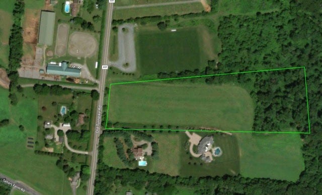
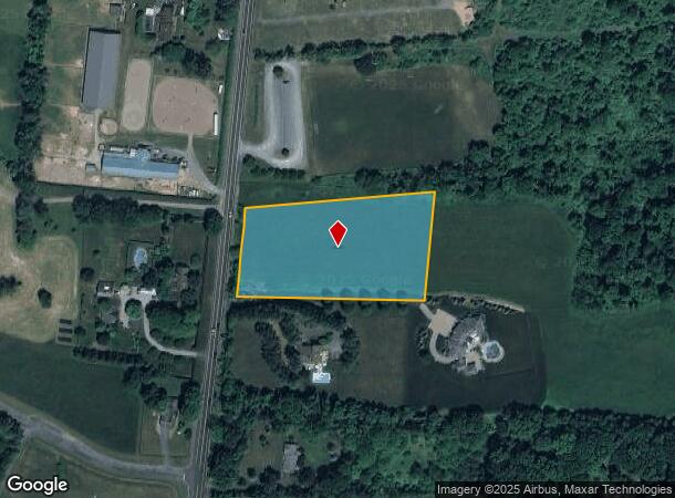
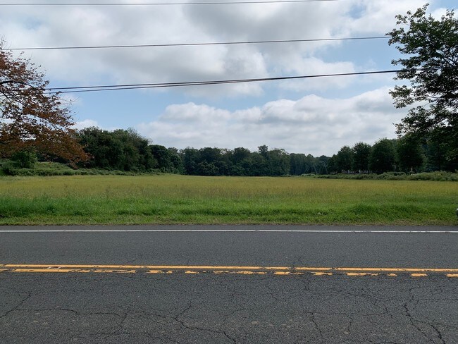
250 Old Turnpike Rd, Califon, NJ 07830
NEARBY LISTINGS FOR SALE OR LEASE
Property Detail
250 Old Turnpike Rd
24-00007-0000-00004-06
Hunterdon
Vacantlandnec
New Jersey
X
4.6
34019C0132F
3.06 AC
2024
Route 78 West
2025
Northern New Jersey
010100
Newark, NJ-PA
DEMOGRAPHICS near 250 Old Turnpike Rd
1 Mile
3 Mile
5 Mile
2024 Total Population
721
5,839
16,135
2029 Population
715
5,780
16,055
Pop Growth 2024-2029
(0.83%)
(1.01%)
(0.50%)
Average Age
44
45
44
2024 Total Households
251
2,063
5,779
HH Growth 2024-2029
(0.80%)
(1.07%)
(0.50%)
Median Household Inc
$178,225
$172,797
$155,645
Avg Household Size
2.80
2.80
2.70
2024 Avg HH Vehicles
3.00
3.00
2.00
Median Home Value
$748,502
$701,834
$626,485
Median Year Built
1974
1975
1975
Nearby Places
Map Layers
Map Styles
 Street
 Aerial
- Restaurants
- Banks
- Shops
- Fitness
- Groceries
PUBLIC TRANSPORTATION
COMMUTER RAIL
Gladstone (Morris & Essex Gladstone Branch - NJ Transit Commuter Rail (NJ Transit))
DRIVE
WALK
Distance
Gladstone (Morris & Essex Gladstone Branch - NJ Transit Commuter Rail (NJ Transit))
13 min
6.8 mi
Peapack (Morris & Essex Gladstone Branch - NJ Transit Commuter Rail (NJ Transit))
DRIVE
WALK
Distance
Peapack (Morris & Essex Gladstone Branch - NJ Transit Commuter Rail (NJ Transit))
14 min
7.9 mi
Freight Ports
New York Container Terminal
DRIVE
WALK
Distance
New York Container Terminal
63 min
44.5 mi
SALE & LEASE HISTORY
LISTING DATE
SALE/LEASE

Sep 20, 2019
For Sale
Jan 13, 2025
For Sale
Nearby Properties
Address
Land Use
TOTAL SIZE
Lot Size
Zoning
Address
Land Use
TOTAL SIZE
Lot Size
Zoning
708.10 AC
R-5
Address
Land Use
TOTAL SIZE
Lot Size
Zoning
23.54 AC
HL
Address
Land Use
TOTAL SIZE
Lot Size
Zoning
14.40 AC
R-1
Address
Land Use
TOTAL SIZE
Lot Size
Zoning
5.70 AC
R-5
Address
Land Use
TOTAL SIZE
Lot Size
Zoning
10 AC
R-5
Address
Land Use
TOTAL SIZE
Lot Size
Zoning
5,846 SF
10 AC
HL
Address
Land Use
TOTAL SIZE
Lot Size
Zoning
9,556 SF
8.37 AC
HL
Address
Land Use
TOTAL SIZE
Lot Size
Zoning
6,217 SF
4 AC
R-5
Address
Land Use
TOTAL SIZE
Lot Size
Zoning
15,667 SF
7.32 AC
FP
Address
Land Use
TOTAL SIZE
Lot Size
Zoning
7,131 SF
2.40 AC
HL
Address
Land Use
TOTAL SIZE
Lot Size
Zoning
1,762 SF
158.59 AC
R-5
Address
Land Use
TOTAL SIZE
Lot Size
Zoning
2,262 SF
167.66 AC
HL
Address
Land Use
TOTAL SIZE
Lot Size
Zoning
2,124 SF
3.50 AC
R-5
Address
Land Use
TOTAL SIZE
Lot Size
Zoning
17.92 AC
R1
Address
Land Use
TOTAL SIZE
Lot Size
Zoning
12,737 SF
4.29 AC
HL
Address
Land Use
TOTAL SIZE
Lot Size
Zoning
14,436 SF
1.50 AC
HL
Address
Land Use
TOTAL SIZE
Lot Size
Zoning
13,975 SF
1 AC
HL
Address
Land Use
TOTAL SIZE
Lot Size
Zoning
9,944 SF
2.59 AC
HL
Address
Land Use
TOTAL SIZE
Lot Size
Zoning
7,652 SF
3.25 AC
HL
Address
Land Use
TOTAL SIZE
Lot Size
Zoning
5,214 SF
1.50 AC
HL
Address
Land Use
TOTAL SIZE
Lot Size
Zoning
8,439 SF
2 AC
R-5
Address
Land Use
TOTAL SIZE
Lot Size
Zoning
8,549 SF
60.68 AC
HL
Address
Land Use
TOTAL SIZE
Lot Size
Zoning
Address
Land Use
TOTAL SIZE
Lot Size
Zoning
9,946 SF
1.50 AC
HL
Address
Land Use
TOTAL SIZE
Lot Size
Zoning
9,638 SF
2.75 AC
HL
Address
Land Use
TOTAL SIZE
Lot Size
Zoning
2,772 SF
112.59 AC
HL
Address
Land Use
TOTAL SIZE
Lot Size
Zoning
8,314 SF
4.30 AC
Address
Land Use
TOTAL SIZE
Lot Size
Zoning
6,633 SF
1 AC
HL
Address
Land Use
TOTAL SIZE
Lot Size
Zoning
6,189 SF
1.50 AC
HL
Address
Land Use
TOTAL SIZE
Lot Size
Zoning
8,523 SF
2 AC
HL
The World's #1 Commercial Real Estate Marketplace
Connect with us
© 2025 CoStar Group
The information above has been obtained from sources believed reliable. While we do not doubt its accuracy we have not verified it and make no guarantee, warranty or representation about it. It is your responsibility to independently confirm its accuracy and completeness. Any projections, opinions, assumptions, or estimates used are for example only and do not represent the current or future performance of the property. The value of this transaction to you depends on tax and other factors which should be evaluated by your tax, financial, and legal advisors. You and your advisors should conduct a careful, independent investigation of the property to determine to your satisfaction the suitability of the property for your needs.