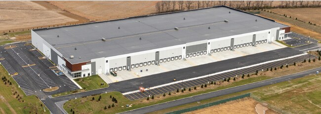
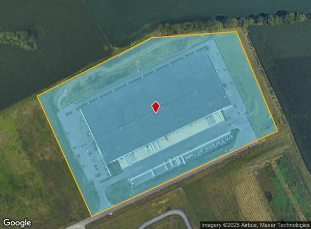
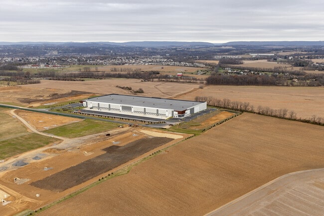
Property Record
250 Radar Dr, Northampton, PA 18067
Current Lease Availabilities
NEARBY LISTINGS FOR SALE OR LEASE
-
-
No Photo
-
-
-
-
-
-
View all Northampton listings for lease on LoopNet.com
Property Detail
250 Radar Dr
M5 2 16D 0501
Allen Township Industrial Subdivision
Industrialpark
Northampton
X
Pennsylvania
42095C0237E
21.68 AC
2025
Lehigh Valley
2025
Philadelphia
016400
Allentown-Bethlehem-Easton, PA-NJ
292,700 SF
DEMOGRAPHICS near 250 Radar Dr
1 Mile
3 Mile
5 Mile
2024 Total Population
1,243
46,119
151,180
2029 Population
1,250
46,513
152,135
Pop Growth 2024-2029
+ 0.56%
+ 0.85%
+ 0.63%
Average Age
45
42
40
2024 Total Households
496
19,018
58,454
HH Growth 2024-2029
+ 0.81%
+ 0.91%
+ 0.61%
Median Household Inc
$84,596
$72,303
$63,273
Avg Household Size
2.50
2.40
2.50
2024 Avg HH Vehicles
2.00
2.00
2.00
Median Home Value
$305,625
$230,962
$221,469
Median Year Built
1994
1964
1962
Nearby Places
Map Layers
Map Styles
 Street
 Aerial
- Restaurants
- Banks
- Shops
- Fitness
- Groceries
PUBLIC TRANSPORTATION
AIRPORT
Lehigh Valley International
DRIVE
WALK
Distance
Lehigh Valley International
8 min
2.4 mi
Freight Ports
Port of Philadelphia
DRIVE
WALK
Distance
Port of Philadelphia
95 min
68.5 mi
Nearby Properties
Address
Land Use
TOTAL SIZE
Lot Size
Zoning
Address
Land Use
TOTAL SIZE
Lot Size
Zoning
93,719 SF
789.61 AC
AI
Address
Land Use
TOTAL SIZE
Lot Size
Zoning
298,543 SF
55.08 AC
PIO
Address
Land Use
TOTAL SIZE
Lot Size
Zoning
453,600 SF
32.57 AC
PIO
Address
Land Use
TOTAL SIZE
Lot Size
Zoning
1,046,625 SF
69.55 AC
RS
Address
Land Use
TOTAL SIZE
Lot Size
Zoning
520,201 SF
77.66 AC
PIO
Address
Land Use
TOTAL SIZE
Lot Size
Zoning
956,444 SF
I
Address
Land Use
TOTAL SIZE
Lot Size
Zoning
13,164 SF
27.89 AC
RT
Address
Land Use
TOTAL SIZE
Lot Size
Zoning
72,678 SF
17.21 AC
PC
Address
Land Use
TOTAL SIZE
Lot Size
Zoning
85.20 AC
I2
Address
Land Use
TOTAL SIZE
Lot Size
Zoning
260,803 SF
36.23 AC
C-2
Address
Land Use
TOTAL SIZE
Lot Size
Zoning
1,050,392 SF
218.15 AC
RS
Address
Land Use
TOTAL SIZE
Lot Size
Zoning
509,445 SF
43.15 AC
PIO
Address
Land Use
TOTAL SIZE
Lot Size
Zoning
605,893 SF
I
Address
Land Use
TOTAL SIZE
Lot Size
Zoning
164,451 SF
15.06 AC
PI
Address
Land Use
TOTAL SIZE
Lot Size
Zoning
8,352 SF
17.24 AC
MR
Address
Land Use
TOTAL SIZE
Lot Size
Zoning
95,776 SF
23.70 AC
INS
Address
Land Use
TOTAL SIZE
Lot Size
Zoning
134,774 SF
11.74 AC
PC
Address
Land Use
TOTAL SIZE
Lot Size
Zoning
452,012 SF
40.39 AC
PC
Address
Land Use
TOTAL SIZE
Lot Size
Zoning
100,754 SF
16.01 AC
PIO
Address
Land Use
TOTAL SIZE
Lot Size
Zoning
185,794 SF
30.91 AC
C-2
Address
Land Use
TOTAL SIZE
Lot Size
Zoning
96,999 SF
19.37 AC
INS
Address
Land Use
TOTAL SIZE
Lot Size
Zoning
75,091 SF
5.23 AC
PUD
Address
Land Use
TOTAL SIZE
Lot Size
Zoning
11,356 SF
16.26 AC
RG
Address
Land Use
TOTAL SIZE
Lot Size
Zoning
197,120 SF
14.06 AC
PIO
Address
Land Use
TOTAL SIZE
Lot Size
Zoning
84,438 SF
7.81 AC
AI
Address
Land Use
TOTAL SIZE
Lot Size
Zoning
1,000 SF
24.24 AC
AI
Address
Land Use
TOTAL SIZE
Lot Size
Zoning
105,219 SF
47.10 AC
RA
Address
Land Use
TOTAL SIZE
Lot Size
Zoning
92,428 SF
3.88 AC
CS
Address
Land Use
TOTAL SIZE
Lot Size
Zoning
6,325 SF
4.96 AC
CS
Address
Land Use
TOTAL SIZE
Lot Size
Zoning
116,719 SF
4.91 AC
PI
The World's #1 Commercial Real Estate Marketplace
Connect with us
© 2025 CoStar Group
The information above has been obtained from sources believed reliable. While we do not doubt its accuracy we have not verified it and make no guarantee, warranty or representation about it. It is your responsibility to independently confirm its accuracy and completeness. Any projections, opinions, assumptions, or estimates used are for example only and do not represent the current or future performance of the property. The value of this transaction to you depends on tax and other factors which should be evaluated by your tax, financial, and legal advisors. You and your advisors should conduct a careful, independent investigation of the property to determine to your satisfaction the suitability of the property for your needs.