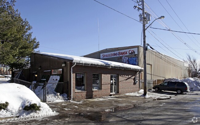
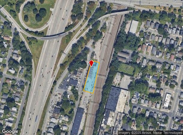
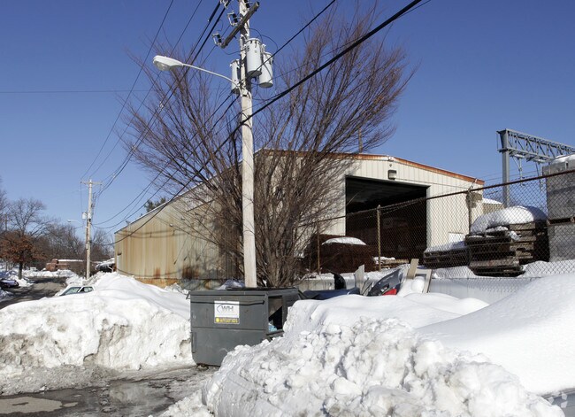
Property Record
250 Station St, Cranston, RI 02910
NEARBY LISTINGS FOR SALE OR LEASE
Property Detail
250 Station St
CRAN-000003-000003-000055
Providence
Industrialgeneral
Rhode Island
X
55
44003C0018H
0.54 AC
2025
Cranston
2025
Providence
013701
Providence-Warwick, RI-MA
7,280 SF
DEMOGRAPHICS near 250 Station St
1 Mile
3 Mile
5 Mile
2024 Total Population
17,723
152,498
349,511
2029 Population
17,479
150,744
347,110
Pop Growth 2024-2029
(1.38%)
(1.15%)
(0.69%)
Average Age
39
39
39
2024 Total Households
6,729
59,733
138,221
HH Growth 2024-2029
(1.50%)
(1.01%)
(0.59%)
Median Household Inc
$71,962
$58,460
$64,791
Avg Household Size
2.60
2.40
2.30
2024 Avg HH Vehicles
2.00
2.00
2.00
Median Home Value
$264,378
$288,791
$294,259
Median Year Built
1947
1949
1952
Nearby Places
Map Layers
Map Styles
 Street
 Aerial
- Restaurants
- Banks
- Shops
- Fitness
- Groceries
PUBLIC TRANSPORTATION
COMMUTER RAIL
Providence (Providence/Stoughton Line - Massachusetts Bay Transportation Authority Commuter Rail (Purple Line))
DRIVE
WALK
Distance
Providence (Providence/Stoughton Line - Massachusetts Bay Transportation Authority Commuter Rail (Purple Line))
9 min
5.2 mi
DRIVE
WALK
Distance
12 min
5.9 mi
AIRPORT
Rhode Island Tf Green International
DRIVE
WALK
Distance
Rhode Island Tf Green International
14 min
5.7 mi
Worcester Regional
DRIVE
WALK
Distance
Worcester Regional
66 min
48.4 mi
Freight Ports
Port of Davisville, RI
DRIVE
WALK
Distance
Port of Davisville, RI
32 min
19.0 mi
Nearby Properties
Address
Land Use
TOTAL SIZE
Lot Size
Zoning
Address
Land Use
TOTAL SIZE
Lot Size
Zoning
8.93 AC
OS
Address
Land Use
TOTAL SIZE
Lot Size
Zoning
45,000 SF
22.22 AC
M2
Address
Land Use
TOTAL SIZE
Lot Size
Zoning
233,468 SF
1.55 AC
I-1-20
Address
Land Use
TOTAL SIZE
Lot Size
Zoning
244,872 SF
1.25 AC
D-1-12
Address
Land Use
TOTAL SIZE
Lot Size
Zoning
174,352 SF
2.50 AC
I-1-20
Address
Land Use
TOTAL SIZE
Lot Size
Zoning
3.44 AC
D-1-20
Address
Land Use
TOTAL SIZE
Lot Size
Zoning
149,663 SF
1.90 AC
D-1-10
Address
Land Use
TOTAL SIZE
Lot Size
Zoning
13.40 AC
C3
Address
Land Use
TOTAL SIZE
Lot Size
Zoning
36.43 AC
S1
Address
Land Use
TOTAL SIZE
Lot Size
Zoning
221,151 SF
2.13 AC
D-1-12
Address
Land Use
TOTAL SIZE
Lot Size
Zoning
218,167 SF
2.74 AC
D-1-20
Address
Land Use
TOTAL SIZE
Lot Size
Zoning
97,097 SF
0.99 AC
D-1-20
Address
Land Use
TOTAL SIZE
Lot Size
Zoning
Address
Land Use
TOTAL SIZE
Lot Size
Zoning
129,144 SF
3.60 AC
PS
Address
Land Use
TOTAL SIZE
Lot Size
Zoning
215,664 SF
1.52 AC
D-1-12
Address
Land Use
TOTAL SIZE
Lot Size
Zoning
7.53 AC
I-2
Address
Land Use
TOTAL SIZE
Lot Size
Zoning
456,246 SF
1.49 AC
DWTN -
Address
Land Use
TOTAL SIZE
Lot Size
Zoning
6.80 AC
R-3
Address
Land Use
TOTAL SIZE
Lot Size
Zoning
4,954 SF
11.22 AC
C5
Address
Land Use
TOTAL SIZE
Lot Size
Zoning
136,072 SF
1.77 AC
Address
Land Use
TOTAL SIZE
Lot Size
Zoning
131,216 SF
1.77 AC
Address
Land Use
TOTAL SIZE
Lot Size
Zoning
126,703 SF
6.53 AC
I-2
Address
Land Use
TOTAL SIZE
Lot Size
Zoning
122,038 SF
0.84 AC
D-1-12
Address
Land Use
TOTAL SIZE
Lot Size
Zoning
96,639 SF
2.79 AC
C-2
Address
Land Use
TOTAL SIZE
Lot Size
Zoning
118,237 SF
2.90 AC
PS
Address
Land Use
TOTAL SIZE
Lot Size
Zoning
100,980 SF
0.59 AC
Address
Land Use
TOTAL SIZE
Lot Size
Zoning
1.37 AC
D-1-12
Address
Land Use
TOTAL SIZE
Lot Size
Zoning
8.82 AC
M-2
Address
Land Use
TOTAL SIZE
Lot Size
Zoning
1.46 AC
D-1-10
Address
Land Use
TOTAL SIZE
Lot Size
Zoning
174,406 SF
0.68 AC
D-1-10
The World's #1 Commercial Real Estate Marketplace
Connect with us
© 2026 CoStar Group
The information above has been obtained from sources believed reliable. While we do not doubt its accuracy we have not verified it and make no guarantee, warranty or representation about it. It is your responsibility to independently confirm its accuracy and completeness. Any projections, opinions, assumptions, or estimates used are for example only and do not represent the current or future performance of the property. The value of this transaction to you depends on tax and other factors which should be evaluated by your tax, financial, and legal advisors. You and your advisors should conduct a careful, independent investigation of the property to determine to your satisfaction the suitability of the property for your needs.