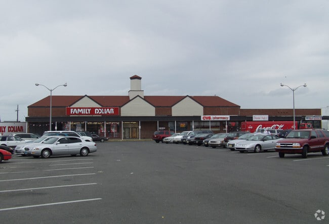
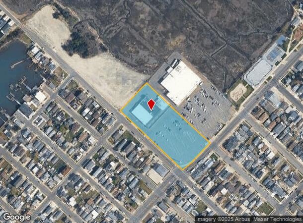
Property Record
2500 Delaware Ave, Wildwood, NJ 08260
NEARBY LISTINGS FOR SALE OR LEASE
Property Detail
2500 Delaware Ave
07-00107-0000-00001
L501-519,1,2
Commercialnec
Cape May
AE
New Jersey
34009C0302F
1
2024
2.47 AC
2025
South Shore/Vineland
021300
Other Market Areas
25,117 SF
Ocean City, NJ
DEMOGRAPHICS near 2500 Delaware Ave
1 Mile
3 Mile
5 Mile
2024 Total Population
8,425
17,691
27,043
2029 Population
8,805
18,666
27,634
Pop Growth 2024-2029
+ 4.51%
+ 5.51%
+ 2.19%
Average Age
46
48
48
2024 Total Households
3,724
7,993
11,942
HH Growth 2024-2029
+ 3.38%
+ 4.64%
+ 1.77%
Median Household Inc
$52,818
$62,859
$69,579
Avg Household Size
2.10
2.00
2.10
2024 Avg HH Vehicles
1.00
1.00
2.00
Median Home Value
$327,176
$357,060
$354,207
Median Year Built
1965
1972
1978
Nearby Places
Map Layers
Map Styles
 Street
 Aerial
- Restaurants
- Banks
- Shops
- Fitness
- Groceries
PUBLIC TRANSPORTATION
AIRPORT
Atlantic City International
DRIVE
WALK
Distance
Atlantic City International
76 min
43.3 mi
Nearby Properties
Address
Land Use
TOTAL SIZE
Lot Size
Zoning
Address
Land Use
TOTAL SIZE
Lot Size
Zoning
165,600 SF
10.73 AC
BRZ
Address
Land Use
TOTAL SIZE
Lot Size
Zoning
3.93 AC
NWM
Address
Land Use
TOTAL SIZE
Lot Size
Zoning
11.41 AC
REC
Address
Land Use
TOTAL SIZE
Lot Size
Zoning
74,412 SF
2.55 AC
ROSE
Address
Land Use
TOTAL SIZE
Lot Size
Zoning
1.40 AC
B
Address
Land Use
TOTAL SIZE
Lot Size
Zoning
2.30 AC
ROSE
Address
Land Use
TOTAL SIZE
Lot Size
Zoning
0.55 AC
M-1A
Address
Land Use
TOTAL SIZE
Lot Size
Zoning
87 SF
M-1A
Address
Land Use
TOTAL SIZE
Lot Size
Zoning
2.25 AC
PARZ
Address
Land Use
TOTAL SIZE
Lot Size
Zoning
0.92 AC
M-1A
Address
Land Use
TOTAL SIZE
Lot Size
Zoning
0.92 AC
M-1A
Address
Land Use
TOTAL SIZE
Lot Size
Zoning
0.92 AC
M-1A
Address
Land Use
TOTAL SIZE
Lot Size
Zoning
5.97 AC
P
Address
Land Use
TOTAL SIZE
Lot Size
Zoning
47,053 SF
0.98 AC
M-1A
Address
Land Use
TOTAL SIZE
Lot Size
Zoning
12,424 SF
1.19 AC
T
Address
Land Use
TOTAL SIZE
Lot Size
Zoning
2.31 AC
RM
Address
Land Use
TOTAL SIZE
Lot Size
Zoning
0.92 AC
M-1A
Address
Land Use
TOTAL SIZE
Lot Size
Zoning
94.91 AC
C
Address
Land Use
TOTAL SIZE
Lot Size
Zoning
10.50 AC
P
Address
Land Use
TOTAL SIZE
Lot Size
Zoning
1.25 AC
M-1B
Address
Land Use
TOTAL SIZE
Lot Size
Zoning
23,156 SF
1.47 AC
M-1C
Address
Land Use
TOTAL SIZE
Lot Size
Zoning
0.74 AC
M-1C
Address
Land Use
TOTAL SIZE
Lot Size
Zoning
3,073 SF
1.74 AC
REC
Address
Land Use
TOTAL SIZE
Lot Size
Zoning
10.88 AC
Address
Land Use
TOTAL SIZE
Lot Size
Zoning
0.64 AC
PARZ
Address
Land Use
TOTAL SIZE
Lot Size
Zoning
0.46 AC
M-1A
Address
Land Use
TOTAL SIZE
Lot Size
Zoning
1.74 AC
REC
Address
Land Use
TOTAL SIZE
Lot Size
Zoning
1.10 AC
OS
Address
Land Use
TOTAL SIZE
Lot Size
Zoning
13,980 SF
2.18 AC
R1
Address
Land Use
TOTAL SIZE
Lot Size
Zoning
0.46 AC
M-1A
The World's #1 Commercial Real Estate Marketplace
Connect with us
© 2025 CoStar Group
The information above has been obtained from sources believed reliable. While we do not doubt its accuracy we have not verified it and make no guarantee, warranty or representation about it. It is your responsibility to independently confirm its accuracy and completeness. Any projections, opinions, assumptions, or estimates used are for example only and do not represent the current or future performance of the property. The value of this transaction to you depends on tax and other factors which should be evaluated by your tax, financial, and legal advisors. You and your advisors should conduct a careful, independent investigation of the property to determine to your satisfaction the suitability of the property for your needs.