Property Record
2500 Harlem Ave, Riverside, IL 60546
Save to a Folder
{{folder.Name}}
{{folder.ListingIds.length}} Properties
{{folder.ListingIds.length}} Property
Create a New Folder
Property Detail
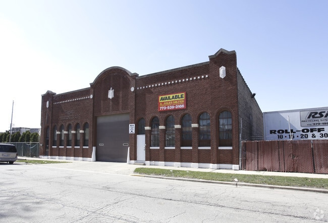
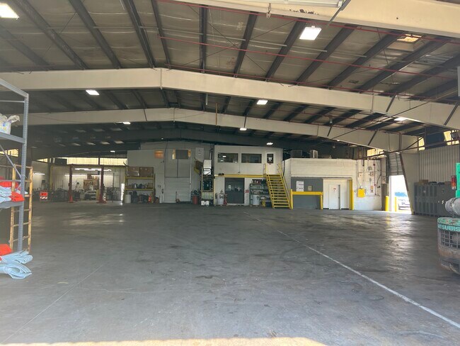
2500 Harlem Ave
Chicago-Naperville-Elgin, IL-IN
(BRADISH) & (MIZNERS) ADD TO (RIVERSIDE) A SUB IN SEC 24-39-12
15-25-201-028-0000
COOK
Vacantlandnec
Illinois
B and X Area of moderate flood hazard, usually the area between the limits of the 100-year and 500-year floods.
46,43
2023
44 SF
2025
West Cook South
816100
Chicago
NEARBY LISTINGS FOR SALE OR LEASE
-
-
-
-
-
-
-
-
-
No Photo
-
View all Riverside listings for lease on LoopNet.com
DEMOGRAPHICS near 2500 Harlem Ave
1 mile
3 mile
5 mile
2025 Total Population
23,584
244,363
618,217
2030 Population
23,406
241,887
605,674
Pop Growth 2025-2030
(0.75%)
(1.01%)
(2.03%)
Average Age
40
40
39
2025 Total Households
9,076
90,928
218,565
HH Growth 2025-2030
(0.74%)
(0.92%)
(2.02%)
Median Household Inc
$76,151
$77,846
$71,661
Avg Household Size
2.50
2.60
2.70
2025 Avg HH Vehicles
1.00
1.00
2.00
Median Home Value
$344,512
$314,159
$294,006
Median Year Built
1947
1947
1948
Nearby Places
Map Layers
Map Styles
 Street
 Aerial
Layers
 Traffic
 Biking
Places
Listings with unknown addresses are not visible on the map
- Restaurants
- Banks
- Shops
- Fitness
- Groceries
PUBLIC TRANSPORTATION
COMMUTER RAIL
Harlem Avenue Station (Burlington Northern-Santa Fe Railway Line - Northeast Illinois Regional Commuter Railroad (Metra))
Drive
Walk
Distance
Harlem Avenue Station (Burlington Northern-Santa Fe Railway Line - Northeast Illinois Regional Commuter Railroad (Metra))
2 min
20 min
1.1 mi
Berwyn Station (Burlington Northern-Santa Fe Railway Line - Northeast Illinois Regional Commuter Railroad (Metra))
Drive
Walk
Distance
Berwyn Station (Burlington Northern-Santa Fe Railway Line - Northeast Illinois Regional Commuter Railroad (Metra))
3 min
1.4 mi
AIRPORT
Chicago Midway International
Drive
Walk
Distance
Chicago Midway International
11 min
6.3 mi
Chicago O'Hare International
Drive
Walk
Distance
Chicago O'Hare International
29 min
14.5 mi
Freight Ports
Port Milwaukee
Drive
Walk
Distance
Port Milwaukee
113 min
91.8 mi
SALE & LEASE HISTORY
LISTING DATE
SALE/LEASE

Sep 24, 2016
For Lease
Oct 11, 2019
For Lease
Mar 24, 2021
For Lease
Jun 26, 2020
For Sale
Jun 16, 2021
For Lease
Jan 20, 2022
For Lease
Aug 30, 2021
For Sale
Nearby Properties
Address
Land Use
TOTAL SIZE
Lot Size
Zoning
Address
Land Use
TOTAL SIZE
Lot Size
Zoning
86,928 SF
4.80 AC
PD 933
Address
Land Use
TOTAL SIZE
Lot Size
Zoning
1,313,541 SF
44.90 AC
M2-2
Address
Land Use
TOTAL SIZE
Lot Size
Zoning
646,763 SF
17.54 AC
Address
Land Use
TOTAL SIZE
Lot Size
Zoning
604,145 SF
28.21 AC
Address
Land Use
TOTAL SIZE
Lot Size
Zoning
377,265 SF
25.73 AC
Address
Land Use
TOTAL SIZE
Lot Size
Zoning
459,659 SF
Address
Land Use
TOTAL SIZE
Lot Size
Zoning
189,908 SF
23.82 AC
Address
Land Use
TOTAL SIZE
Lot Size
Zoning
291,681 SF
Address
Land Use
TOTAL SIZE
Lot Size
Zoning
549,955 SF
18.01 AC
Address
Land Use
TOTAL SIZE
Lot Size
Zoning
578,024 SF
31.94 AC
Address
Land Use
TOTAL SIZE
Lot Size
Zoning
108,276 SF
3.80 AC
Address
Land Use
TOTAL SIZE
Lot Size
Zoning
220,137 SF
13.24 AC
Address
Land Use
TOTAL SIZE
Lot Size
Zoning
225,000 SF
5.82 AC
Address
Land Use
TOTAL SIZE
Lot Size
Zoning
153,954 SF
14.36 AC
Address
Land Use
TOTAL SIZE
Lot Size
Zoning
1,107,999 SF
119.41 AC
Address
Land Use
TOTAL SIZE
Lot Size
Zoning
101,146 SF
2.24 AC
Address
Land Use
TOTAL SIZE
Lot Size
Zoning
89,919 SF
2.87 AC
Address
Land Use
TOTAL SIZE
Lot Size
Zoning
7.68 AC
Address
Land Use
TOTAL SIZE
Lot Size
Zoning
313,899 SF
13.43 AC
Address
Land Use
TOTAL SIZE
Lot Size
Zoning
206,736 SF
10.38 AC
Address
Land Use
TOTAL SIZE
Lot Size
Zoning
193,511 SF
17.89 AC
Address
Land Use
TOTAL SIZE
Lot Size
Zoning
53,800 SF
0.88 AC
Address
Land Use
TOTAL SIZE
Lot Size
Zoning
120,929 SF
9 AC
Address
Land Use
TOTAL SIZE
Lot Size
Zoning
365,359 SF
25.39 AC
Address
Land Use
TOTAL SIZE
Lot Size
Zoning
242,662 SF
21.02 AC
Address
Land Use
TOTAL SIZE
Lot Size
Zoning
8.92 AC
Address
Land Use
TOTAL SIZE
Lot Size
Zoning
99,175 SF
3.65 AC
M2-2
Address
Land Use
TOTAL SIZE
Lot Size
Zoning
Address
Land Use
TOTAL SIZE
Lot Size
Zoning
303,192 SF
15.47 AC
Address
Land Use
TOTAL SIZE
Lot Size
Zoning
0.11 AC
The World's #1 Commercial Real Estate Marketplace
Connect with us
© 2026 CoStar Group
The information above has been obtained from sources believed reliable. While we do not doubt its accuracy we have not verified it and make no guarantee, warranty or representation about it. It is your responsibility to independently confirm its accuracy and completeness. Any projections, opinions, assumptions, or estimates used are for example only and do not represent the current or future performance of the property. The value of this transaction to you depends on tax and other factors which should be evaluated by your tax, financial, and legal advisors. You and your advisors should conduct a careful, independent investigation of the property to determine to your satisfaction the suitability of the property for your needs.