Property Record
2500 Hickory Rd, Canton, GA 30115

Property Detail
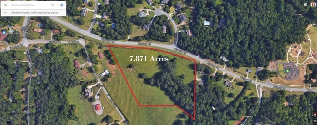
2500 Hickory Rd
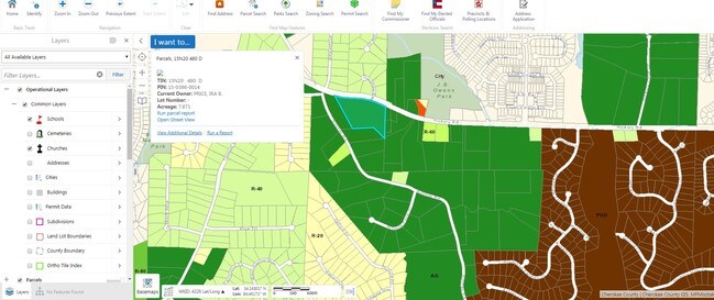
015N20-00000-480-00D-0000
LL 386 15TH D TR 5
Agriculturalland
CHEROKEE
AG
Georgia
B and X Area of moderate flood hazard, usually the area between the limits of the 100-year and 500-year floods.
7.87 AC
2025
Cherokee County
2025
Atlanta
090808
Atlanta-Sandy Springs-Roswell, GA
NEARBY LISTINGS FOR SALE OR LEASE
DEMOGRAPHICS near 2500 Hickory Rd
1 mile
3 mile
5 mile
2025 Total Population
5,973
37,423
102,621
2030 Population
6,400
40,304
110,512
Pop Growth 2025-2030
+ 7.15%
+ 7.70%
+ 7.69%
Average Age
39
40
39
2025 Total Households
2,022
13,081
35,722
HH Growth 2025-2030
+ 7.17%
+ 7.81%
+ 7.78%
Median Household Inc
$121,874
$110,396
$111,524
Avg Household Size
2.90
2.80
2.80
2025 Avg HH Vehicles
2.00
2.00
2.00
Median Home Value
$454,475
$464,621
$464,902
Median Year Built
2003
2001
2002
Nearby Places
Map Layers
Map Styles
 Street
 Aerial
Layers
 Traffic
 Biking
Places
Listings with unknown addresses are not visible on the map
- Restaurants
- Banks
- Shops
- Fitness
- Groceries
SALE & LEASE HISTORY
LISTING DATE
SALE/LEASE

May 08, 2019
For Sale
Nearby Properties
Address
Land Use
TOTAL SIZE
Lot Size
Zoning
Address
Land Use
TOTAL SIZE
Lot Size
Zoning
611,396 SF
93.78 AC
R-40
Address
Land Use
TOTAL SIZE
Lot Size
Zoning
275,118 SF
21.61 AC
R-40
Address
Land Use
TOTAL SIZE
Lot Size
Zoning
255,483 SF
138.30 AC
LI
Address
Land Use
TOTAL SIZE
Lot Size
Zoning
353,395 SF
29.15 AC
GC
Address
Land Use
TOTAL SIZE
Lot Size
Zoning
145,195 SF
14.47 AC
R-40
Address
Land Use
TOTAL SIZE
Lot Size
Zoning
75,645 SF
16.76 AC
OI
Address
Land Use
TOTAL SIZE
Lot Size
Zoning
149,713 SF
36.97 AC
R-80
Address
Land Use
TOTAL SIZE
Lot Size
Zoning
182,067 SF
23.83 AC
GC
Address
Land Use
TOTAL SIZE
Lot Size
Zoning
134,017 SF
42.78 AC
AG
Address
Land Use
TOTAL SIZE
Lot Size
Zoning
123,941 SF
18.41 AC
GC
Address
Land Use
TOTAL SIZE
Lot Size
Zoning
66,439 SF
3.59 AC
GC
Address
Land Use
TOTAL SIZE
Lot Size
Zoning
44,397 SF
15.84 AC
GC
Address
Land Use
TOTAL SIZE
Lot Size
Zoning
69,360 SF
5.86 AC
R-80
Address
Land Use
TOTAL SIZE
Lot Size
Zoning
60,882 SF
12.94 AC
GC
Address
Land Use
TOTAL SIZE
Lot Size
Zoning
30,996 SF
2.05 AC
PDR
Address
Land Use
TOTAL SIZE
Lot Size
Zoning
158,853 SF
33.73 AC
LI
Address
Land Use
TOTAL SIZE
Lot Size
Zoning
31,232 SF
8.61 AC
LI
Address
Land Use
TOTAL SIZE
Lot Size
Zoning
55,778 SF
5.28 AC
GC
Address
Land Use
TOTAL SIZE
Lot Size
Zoning
110,264 SF
8.83 AC
LI
Address
Land Use
TOTAL SIZE
Lot Size
Zoning
40,590 SF
2.80 AC
GC
Address
Land Use
TOTAL SIZE
Lot Size
Zoning
24,158 SF
2.59 AC
NC
Address
Land Use
TOTAL SIZE
Lot Size
Zoning
30,603 SF
3.76 AC
GC
Address
Land Use
TOTAL SIZE
Lot Size
Zoning
30,080 SF
7.31 AC
GC
Address
Land Use
TOTAL SIZE
Lot Size
Zoning
1,428 SF
43.56 AC
R-80
Address
Land Use
TOTAL SIZE
Lot Size
Zoning
56,610 SF
5.95 AC
GV
Address
Land Use
TOTAL SIZE
Lot Size
Zoning
9,712 SF
180.89 AC
PUD
Address
Land Use
TOTAL SIZE
Lot Size
Zoning
42,107 SF
6.66 AC
GC
Address
Land Use
TOTAL SIZE
Lot Size
Zoning
33,484 SF
5 AC
R-80
Address
Land Use
TOTAL SIZE
Lot Size
Zoning
13,320 SF
2.67 AC
NC
Address
Land Use
TOTAL SIZE
Lot Size
Zoning
19,105 SF
17.30 AC
LI
The World's #1 Commercial Real Estate Marketplace
Connect with us
© 2026 CoStar Group
The information above has been obtained from sources believed reliable. While we do not doubt its accuracy we have not verified it and make no guarantee, warranty or representation about it. It is your responsibility to independently confirm its accuracy and completeness. Any projections, opinions, assumptions, or estimates used are for example only and do not represent the current or future performance of the property. The value of this transaction to you depends on tax and other factors which should be evaluated by your tax, financial, and legal advisors. You and your advisors should conduct a careful, independent investigation of the property to determine to your satisfaction the suitability of the property for your needs.