Property Record
2500 Highway 155 N, Mcdonough, GA 30252

NEARBY LISTINGS FOR SALE OR LEASE
Property Detail
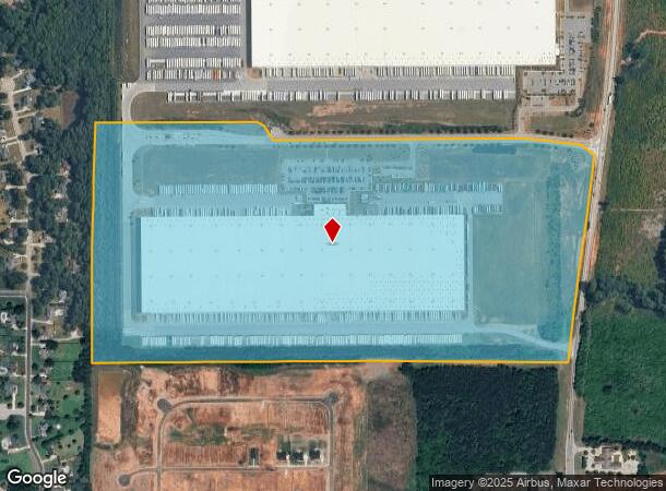
2500 Highway 155 N
0078-01-001-001
3.399 ACRES; LAND LOT: +239 /LAND DISTRICT: 2; INDUSTRIAL
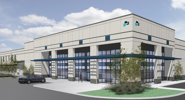
Distributionwarehouseregional
Henry
X
Georgia
13255C0085E
88.82 AC
2025
S Clayton/Henry Cnty
2025
Atlanta
070208
Atlanta-Sandy Springs-Roswell, GA
1,126,973 SF
DEMOGRAPHICS near 2500 Highway 155 N
1 Mile
3 Mile
5 Mile
2024 Total Population
2,353
19,540
50,451
2029 Population
2,587
21,534
55,456
Pop Growth 2024-2029
+ 9.94%
+ 10.20%
+ 9.92%
Average Age
37
37
37
2024 Total Households
799
6,463
17,877
HH Growth 2024-2029
+ 10.01%
+ 10.34%
+ 10.02%
Median Household Inc
$79,424
$86,274
$72,166
Avg Household Size
3.00
3.00
2.80
2024 Avg HH Vehicles
2.00
2.00
2.00
Median Home Value
$236,417
$255,431
$226,768
Median Year Built
2007
2006
2004
Nearby Places
Map Layers
Map Styles
 Street
 Aerial
- Restaurants
- Banks
- Shops
- Fitness
- Groceries
PUBLIC TRANSPORTATION
AIRPORT
Hartsfield - Jackson Atlanta International
DRIVE
WALK
Distance
Hartsfield - Jackson Atlanta International
38 min
28.1 mi
Freight Ports
Georgia Ports - Savannah
DRIVE
WALK
Distance
Georgia Ports - Savannah
245 min
217.7 mi
Nearby Properties
Address
Land Use
TOTAL SIZE
Lot Size
Zoning
Address
Land Use
TOTAL SIZE
Lot Size
Zoning
5,174,944 SF
107.34 AC
M1
Address
Land Use
TOTAL SIZE
Lot Size
Zoning
2,016,606 SF
61.08 AC
M
Address
Land Use
TOTAL SIZE
Lot Size
Zoning
1,079,756 SF
92.38 AC
M1
Address
Land Use
TOTAL SIZE
Lot Size
Zoning
1,010,600 SF
78.40 AC
M1
Address
Land Use
TOTAL SIZE
Lot Size
Zoning
1,126,973 SF
88.82 AC
M1
Address
Land Use
TOTAL SIZE
Lot Size
Zoning
1,038,514 SF
141.54 AC
M1
Address
Land Use
TOTAL SIZE
Lot Size
Zoning
247,544 SF
43.30 AC
Address
Land Use
TOTAL SIZE
Lot Size
Zoning
4,307,236 SF
66.85 AC
M1
Address
Land Use
TOTAL SIZE
Lot Size
Zoning
7,005,327 SF
56.89 AC
M1
Address
Land Use
TOTAL SIZE
Lot Size
Zoning
18,084 SF
59.72 AC
M1
Address
Land Use
TOTAL SIZE
Lot Size
Zoning
22,633 SF
31 AC
RM
Address
Land Use
TOTAL SIZE
Lot Size
Zoning
4,982 SF
34.62 AC
RM
Address
Land Use
TOTAL SIZE
Lot Size
Zoning
21,308 SF
14.22 AC
M1
Address
Land Use
TOTAL SIZE
Lot Size
Zoning
676,000 SF
40.84 AC
M
Address
Land Use
TOTAL SIZE
Lot Size
Zoning
4,536,950 SF
47.66 AC
C1
Address
Land Use
TOTAL SIZE
Lot Size
Zoning
5,681,569 SF
37.80 AC
M1
Address
Land Use
TOTAL SIZE
Lot Size
Zoning
2,877,520 SF
53.73 AC
C2
Address
Land Use
TOTAL SIZE
Lot Size
Zoning
6,101,324 SF
42.27 AC
M1
Address
Land Use
TOTAL SIZE
Lot Size
Zoning
1,871,190 SF
46.24 AC
M1
Address
Land Use
TOTAL SIZE
Lot Size
Zoning
1,122,282 SF
39.20 AC
M2
Address
Land Use
TOTAL SIZE
Lot Size
Zoning
427,200 SF
67.92 AC
PD
Address
Land Use
TOTAL SIZE
Lot Size
Zoning
756,765 SF
50.68 AC
M1
Address
Land Use
TOTAL SIZE
Lot Size
Zoning
3,783,900 SF
43.09 AC
M1
Address
Land Use
TOTAL SIZE
Lot Size
Zoning
3,137,442 SF
53.75 AC
M1
Address
Land Use
TOTAL SIZE
Lot Size
Zoning
3,060,922 SF
27.99 AC
M1
Address
Land Use
TOTAL SIZE
Lot Size
Zoning
814,754 SF
21.65 AC
M1
Address
Land Use
TOTAL SIZE
Lot Size
Zoning
977,344 SF
32.79 AC
M1
Address
Land Use
TOTAL SIZE
Lot Size
Zoning
2,307,900 SF
27.52 AC
M1
Address
Land Use
TOTAL SIZE
Lot Size
Zoning
926,735 SF
25.94 AC
Address
Land Use
TOTAL SIZE
Lot Size
Zoning
297,051 SF
33.41 AC
M1
The World's #1 Commercial Real Estate Marketplace
Connect with us
© 2025 CoStar Group
The information above has been obtained from sources believed reliable. While we do not doubt its accuracy we have not verified it and make no guarantee, warranty or representation about it. It is your responsibility to independently confirm its accuracy and completeness. Any projections, opinions, assumptions, or estimates used are for example only and do not represent the current or future performance of the property. The value of this transaction to you depends on tax and other factors which should be evaluated by your tax, financial, and legal advisors. You and your advisors should conduct a careful, independent investigation of the property to determine to your satisfaction the suitability of the property for your needs.