Property Record
2500 Joan Ave, Panama City, FL 32408


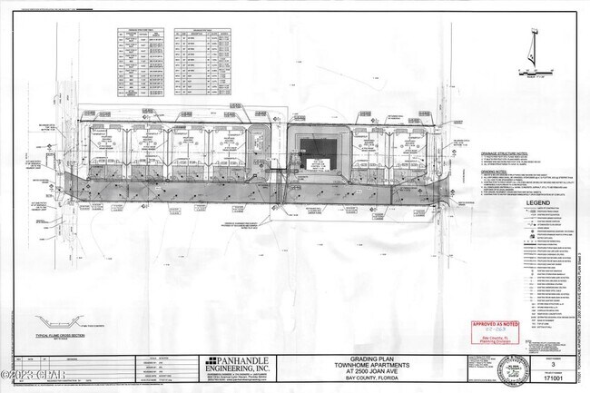
Property Detail
2500 Joan Ave
30223-000-000
6 4S 15W -11.227- 58B2 BEG 337.5 E & 560 S OF NW COR OF NE1/4 OF NW1/4 OF SEC 6 TH RUN E 434.58 S 100.04 TH WR 434.67 N 100 TO POB AKA LOTS 3 & 25 BLK 4 OF LAGOON HEIGHTS UNREC ORB 4578 P 2391
Residentialacreage
BAY
BC16
Florida
AE The base floodplain where base flood elevations are provided. AE Zones are now used on new format FIRMs instead of A1-A30 Zones.
3
2024
1 AC
2025
Panama City
002604
Other Market Areas
754 SF
Panama City-Panama City Beach, FL
NEARBY LISTINGS FOR SALE OR LEASE
-
-
-
-
-
Panama City Beach Parkway
Panama City Beach, FL 32407
$1,572,000 - $11,412,000
1.31 - 1.48 AC Lot
Land
-
-
-
View all Panama City listings for sale on LoopNet.com
DEMOGRAPHICS near 2500 Joan Ave
1 mile
3 mile
5 mile
2025 Total Population
10,403
38,288
54,092
2030 Population
12,290
45,047
63,155
Pop Growth 2025-2030
+ 18.14%
+ 17.65%
+ 16.75%
Average Age
45
43
44
2025 Total Households
4,820
17,356
24,135
HH Growth 2025-2030
+ 19.05%
+ 18.36%
+ 17.44%
Median Household Inc
$67,266
$72,641
$72,920
Avg Household Size
2.10
2.20
2.20
2025 Avg HH Vehicles
2.00
2.00
2.00
Median Home Value
$375,435
$383,606
$390,463
Median Year Built
1999
1999
1997
Nearby Places
Map Layers
Map Styles
 Street
 Aerial
Layers
 Traffic
 Biking
Places
Listings with unknown addresses are not visible on the map
- Restaurants
- Banks
- Shops
- Fitness
- Groceries
PUBLIC TRANSPORTATION
AIRPORT
Northwest Florida Beaches International
Drive
Walk
Distance
Northwest Florida Beaches International
31 min
19.9 mi
Freight Ports
Port of Panama City
Drive
Walk
Distance
Port of Panama City
8 min
4.2 mi
SALE & LEASE HISTORY
LISTING DATE
SALE/LEASE

Mar 14, 2024
For Sale
Nearby Properties
Address
Land Use
TOTAL SIZE
Lot Size
Zoning
Address
Land Use
TOTAL SIZE
Lot Size
Zoning
96 AC
BC14
Address
Land Use
TOTAL SIZE
Lot Size
Zoning
68 AC
BC14
Address
Land Use
TOTAL SIZE
Lot Size
Zoning
176.88 AC
BC14
Address
Land Use
TOTAL SIZE
Lot Size
Zoning
341,086 SF
18.98 AC
PCB21
Address
Land Use
TOTAL SIZE
Lot Size
Zoning
350,105 SF
16.70 AC
PCB24
Address
Land Use
TOTAL SIZE
Lot Size
Zoning
335,150 SF
17.17 AC
BC05
Address
Land Use
TOTAL SIZE
Lot Size
Zoning
253,262 SF
2.35 AC
PCB21
Address
Land Use
TOTAL SIZE
Lot Size
Zoning
354,137 SF
20.13 AC
PCB22
Address
Land Use
TOTAL SIZE
Lot Size
Zoning
285,798 SF
16.50 AC
BC19
Address
Land Use
TOTAL SIZE
Lot Size
Zoning
293,715 SF
18.13 AC
BC19
Address
Land Use
TOTAL SIZE
Lot Size
Zoning
370,951 SF
19.87 AC
PCB22
Address
Land Use
TOTAL SIZE
Lot Size
Zoning
328,049 SF
33.54 AC
PCB17
Address
Land Use
TOTAL SIZE
Lot Size
Zoning
40,690 SF
24.86 AC
BC19
Address
Land Use
TOTAL SIZE
Lot Size
Zoning
254,904 SF
20.60 AC
BC05
Address
Land Use
TOTAL SIZE
Lot Size
Zoning
186,975 SF
4.12 AC
PCB21
Address
Land Use
TOTAL SIZE
Lot Size
Zoning
313,808 SF
121.61 AC
PCB24
Address
Land Use
TOTAL SIZE
Lot Size
Zoning
210,652 SF
19.47 AC
BC19
Address
Land Use
TOTAL SIZE
Lot Size
Zoning
2,560 SF
8.26 AC
PCB10
Address
Land Use
TOTAL SIZE
Lot Size
Zoning
132,433 SF
6.43 AC
PCB21
Address
Land Use
TOTAL SIZE
Lot Size
Zoning
56,045 SF
2.82 AC
BC05
Address
Land Use
TOTAL SIZE
Lot Size
Zoning
176,759 SF
20 AC
PCB24
Address
Land Use
TOTAL SIZE
Lot Size
Zoning
43,287 SF
7.73 AC
BC04
Address
Land Use
TOTAL SIZE
Lot Size
Zoning
166,871 SF
39.70 AC
PCB22
Address
Land Use
TOTAL SIZE
Lot Size
Zoning
97,474 SF
11.55 AC
PCB21
Address
Land Use
TOTAL SIZE
Lot Size
Zoning
85,200 SF
6.87 AC
BC05
Address
Land Use
TOTAL SIZE
Lot Size
Zoning
22,462 SF
1.99 AC
BC05
Address
Land Use
TOTAL SIZE
Lot Size
Zoning
14,183 SF
11.99 AC
PCB22
Address
Land Use
TOTAL SIZE
Lot Size
Zoning
216,844 SF
25.60 AC
PCB22
Address
Land Use
TOTAL SIZE
Lot Size
Zoning
167,886 SF
15.88 AC
PCB19
Address
Land Use
TOTAL SIZE
Lot Size
Zoning
145,935 SF
45.63 AC
The World's #1 Commercial Real Estate Marketplace
Connect with us
© 2026 CoStar Group
The information above has been obtained from sources believed reliable. While we do not doubt its accuracy we have not verified it and make no guarantee, warranty or representation about it. It is your responsibility to independently confirm its accuracy and completeness. Any projections, opinions, assumptions, or estimates used are for example only and do not represent the current or future performance of the property. The value of this transaction to you depends on tax and other factors which should be evaluated by your tax, financial, and legal advisors. You and your advisors should conduct a careful, independent investigation of the property to determine to your satisfaction the suitability of the property for your needs.