Property Record
2500 Mcfarland Blvd, Northport, AL 35476
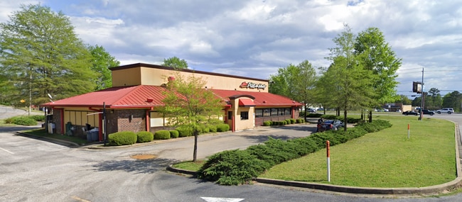
This Property Is For Sale
NEARBY LISTINGS FOR SALE OR LEASE
Property Detail
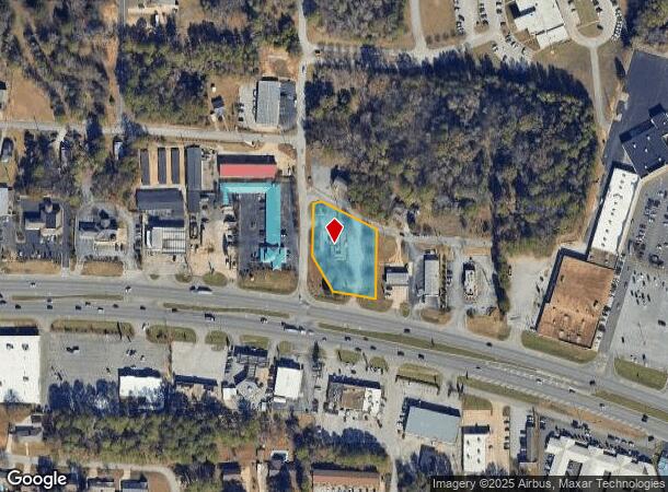
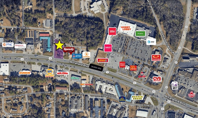
2500 Mcfarland Blvd
31-02-09-1-001-010.001
COM INT E LN LOT 1 SALLY SHIRLEY SURVEY & N R/W HWY 82; NW 44.8 TO POB; N 196.8; NWLY 185(S); SW 22.4; S 180.7; SE 115.7; SE 131(S) TO POB
Restaurantbuilding
Tuscaloosa
X
Alabama
01125C0502F
1
2025
0.98 AC
2024
Tuscaloosa
010206
Birmingham
3,778 SF
Tuscaloosa, AL
DEMOGRAPHICS near 2500 Mcfarland Blvd
1 Mile
3 Mile
5 Mile
2024 Total Population
7,080
50,823
111,398
2029 Population
7,934
56,614
125,126
Pop Growth 2024-2029
+ 12.06%
+ 11.39%
+ 12.32%
Average Age
45
36
34
2024 Total Households
2,476
17,933
40,636
HH Growth 2024-2029
+ 12.48%
+ 14.28%
+ 14.46%
Median Household Inc
$70,016
$55,314
$45,377
Avg Household Size
2.30
2.10
2.20
2024 Avg HH Vehicles
2.00
2.00
2.00
Median Home Value
$190,472
$227,120
$235,216
Median Year Built
1978
1986
1991
Nearby Places
Map Layers
Map Styles
 Street
 Aerial
- Restaurants
- Banks
- Shops
- Fitness
- Groceries
PUBLIC TRANSPORTATION
COMMUTER RAIL
Tuscaloosa Amtrak Station (Crescent - Amtrak)
DRIVE
WALK
Distance
Tuscaloosa Amtrak Station (Crescent - Amtrak)
7 min
4.0 mi
Freight Ports
Port of Mobile
DRIVE
WALK
Distance
Port of Mobile
243 min
202.8 mi
Nearby Properties
Address
Land Use
TOTAL SIZE
Lot Size
Zoning
Address
Land Use
TOTAL SIZE
Lot Size
Zoning
148,656 SF
2.79 AC
BC
Address
Land Use
TOTAL SIZE
Lot Size
Zoning
160,989 SF
1.53 AC
RMF2
Address
Land Use
TOTAL SIZE
Lot Size
Zoning
1.33 AC
BC
Address
Land Use
TOTAL SIZE
Lot Size
Zoning
176,360 SF
1.13 AC
RMF2
Address
Land Use
TOTAL SIZE
Lot Size
Zoning
200,388 SF
1.22 AC
Address
Land Use
TOTAL SIZE
Lot Size
Zoning
105,728 SF
4.75 AC
BGO
Address
Land Use
TOTAL SIZE
Lot Size
Zoning
121,384 SF
21 AC
O-I
Address
Land Use
TOTAL SIZE
Lot Size
Zoning
20,224 SF
19 AC
RM2
Address
Land Use
TOTAL SIZE
Lot Size
Zoning
173,452 SF
2.30 AC
ML
Address
Land Use
TOTAL SIZE
Lot Size
Zoning
144,660 SF
1 AC
RMF2
Address
Land Use
TOTAL SIZE
Lot Size
Zoning
110,000 SF
5.80 AC
RD
Address
Land Use
TOTAL SIZE
Lot Size
Zoning
26,576 SF
2.53 AC
RD
Address
Land Use
TOTAL SIZE
Lot Size
Zoning
15.30 AC
Address
Land Use
TOTAL SIZE
Lot Size
Zoning
12,048 SF
21 AC
RM2
Address
Land Use
TOTAL SIZE
Lot Size
Zoning
301,560 SF
15 AC
ML
Address
Land Use
TOTAL SIZE
Lot Size
Zoning
10,852 SF
46 AC
I
Address
Land Use
TOTAL SIZE
Lot Size
Zoning
73,848 SF
1.73 AC
BGO
Address
Land Use
TOTAL SIZE
Lot Size
Zoning
56,613 SF
2.02 AC
BGO
Address
Land Use
TOTAL SIZE
Lot Size
Zoning
96,885 SF
2.34 AC
RD
Address
Land Use
TOTAL SIZE
Lot Size
Zoning
92,112 SF
0.74 AC
RMF2
Address
Land Use
TOTAL SIZE
Lot Size
Zoning
10,440 SF
12 AC
Address
Land Use
TOTAL SIZE
Lot Size
Zoning
32,640 SF
9.80 AC
C6
Address
Land Use
TOTAL SIZE
Lot Size
Zoning
143,038 SF
36 AC
O-I
Address
Land Use
TOTAL SIZE
Lot Size
Zoning
75,870 SF
5.50 AC
R1
Address
Land Use
TOTAL SIZE
Lot Size
Zoning
7,752 SF
11 AC
R4
Address
Land Use
TOTAL SIZE
Lot Size
Zoning
50,652 SF
19.03 AC
ML
Address
Land Use
TOTAL SIZE
Lot Size
Zoning
4.51 AC
BC
Address
Land Use
TOTAL SIZE
Lot Size
Zoning
73,904 SF
0.97 AC
BC
Address
Land Use
TOTAL SIZE
Lot Size
Zoning
3,808 SF
10 AC
R4
Address
Land Use
TOTAL SIZE
Lot Size
Zoning
3,456 SF
13.98 AC
RM2
The World's #1 Commercial Real Estate Marketplace
Connect with us
© 2026 CoStar Group
The information above has been obtained from sources believed reliable. While we do not doubt its accuracy we have not verified it and make no guarantee, warranty or representation about it. It is your responsibility to independently confirm its accuracy and completeness. Any projections, opinions, assumptions, or estimates used are for example only and do not represent the current or future performance of the property. The value of this transaction to you depends on tax and other factors which should be evaluated by your tax, financial, and legal advisors. You and your advisors should conduct a careful, independent investigation of the property to determine to your satisfaction the suitability of the property for your needs.