Property Record
2500 Myrtle Ave, Eureka, CA 95501
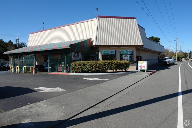

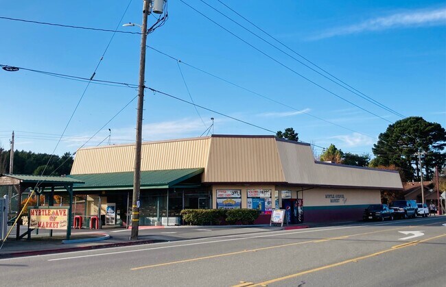

Property Detail
2500 Myrtle Ave
Eureka-Arcata, CA
SUB: 1625, PARCEL MAP PLAT BOOK: P14 PLAT PAGE: 47 LOT: 1
016-152-018-000
Humboldt
Storebuilding
California
CG
1
B and X Area of moderate flood hazard, usually the area between the limits of the 100-year and 500-year floods.
0.72 AC
2024
Eureka/Crescent City
2025
Other Market Areas
000800
NEARBY LISTINGS FOR SALE OR LEASE
DEMOGRAPHICS near 2500 Myrtle Ave
1 mile
3 mile
5 mile
2024 Total Population
6,556
39,529
46,539
2029 Population
6,475
38,913
45,771
Pop Growth 2024-2029
(1.24%)
(1.56%)
(1.65%)
Average Age
44
42
42
2024 Total Households
2,730
16,519
19,382
HH Growth 2024-2029
(1.32%)
(1.59%)
(1.70%)
Median Household Inc
$65,561
$63,815
$65,251
Avg Household Size
2.20
2.30
2.30
2024 Avg HH Vehicles
2.00
2.00
2.00
Median Home Value
$491,556
$454,448
$460,586
Median Year Built
1966
1959
1961
Nearby Places
Map Layers
Map Styles
 Street
 Aerial
Transit
 Traffic
 Biking
Places
Listings with unknown addresses are not visible on the map
- Restaurants
- Banks
- Shops
- Fitness
- Groceries
PUBLIC TRANSPORTATION
AIRPORT
California Redwood Coast-Humboldt County
Drive
Walk
Distance
California Redwood Coast-Humboldt County
26 min
17.4 mi
Freight Ports
Port of Coos Bay, OR
Drive
Walk
Distance
Port of Coos Bay, OR
293 min
217.4 mi
SALE & LEASE HISTORY
LISTING DATE
SALE/LEASE

Dec 01, 2020
For Sale
Nearby Properties
Address
Land Use
TOTAL SIZE
Lot Size
Zoning
Address
Land Use
TOTAL SIZE
Lot Size
Zoning
8.22 AC
HM,RS-6000
Address
Land Use
TOTAL SIZE
Lot Size
Zoning
126,563 SF
10.81 AC
CS
Address
Land Use
TOTAL SIZE
Lot Size
Zoning
10.57 AC
R-1
Address
Land Use
TOTAL SIZE
Lot Size
Zoning
45,840 SF
21.83 AC
MG
Address
Land Use
TOTAL SIZE
Lot Size
Zoning
9.39 AC
MG
Address
Land Use
TOTAL SIZE
Lot Size
Zoning
3.96 AC
RM-1000,NR
Address
Land Use
TOTAL SIZE
Lot Size
Zoning
2.11 AC
RM-1000
Address
Land Use
TOTAL SIZE
Lot Size
Zoning
3.72 AC
C-1/GO
Address
Land Use
TOTAL SIZE
Lot Size
Zoning
4.65 AC
HM
Address
Land Use
TOTAL SIZE
Lot Size
Zoning
1.19 AC
C-1-Q
Address
Land Use
TOTAL SIZE
Lot Size
Zoning
7.14 AC
CS
Address
Land Use
TOTAL SIZE
Lot Size
Zoning
1.86 AC
CS
Address
Land Use
TOTAL SIZE
Lot Size
Zoning
6.75 AC
CP
Address
Land Use
TOTAL SIZE
Lot Size
Zoning
7.64 AC
CP
Address
Land Use
TOTAL SIZE
Lot Size
Zoning
0.61 AC
Address
Land Use
TOTAL SIZE
Lot Size
Zoning
2.06 AC
R-4*;RM-30
Address
Land Use
TOTAL SIZE
Lot Size
Zoning
41,346 SF
0.32 AC
Address
Land Use
TOTAL SIZE
Lot Size
Zoning
7,148 SF
0.46 AC
OR-AR
Address
Land Use
TOTAL SIZE
Lot Size
Zoning
26,829 SF
2.47 AC
C-1
Address
Land Use
TOTAL SIZE
Lot Size
Zoning
0.62 AC
RM-1000
Address
Land Use
TOTAL SIZE
Lot Size
Zoning
0.45 AC
CC-LW
Address
Land Use
TOTAL SIZE
Lot Size
Zoning
1.32 AC
CC-AR
Address
Land Use
TOTAL SIZE
Lot Size
Zoning
1.23 AC
RS-5
Address
Land Use
TOTAL SIZE
Lot Size
Zoning
2.40 AC
NR,CS
Address
Land Use
TOTAL SIZE
Lot Size
Zoning
2.58 AC
ML,CS
Address
Land Use
TOTAL SIZE
Lot Size
Zoning
1.08 AC
Address
Land Use
TOTAL SIZE
Lot Size
Zoning
1.32 AC
CS
Address
Land Use
TOTAL SIZE
Lot Size
Zoning
0.19 AC
CC-LW
Address
Land Use
TOTAL SIZE
Lot Size
Zoning
77,699 SF
2.79 AC
CS
Address
Land Use
TOTAL SIZE
Lot Size
Zoning
22,776 SF
0.99 AC
CS
The World's #1 Commercial Real Estate Marketplace
Connect with us
© 2026 CoStar Group
The information above has been obtained from sources believed reliable. While we do not doubt its accuracy we have not verified it and make no guarantee, warranty or representation about it. It is your responsibility to independently confirm its accuracy and completeness. Any projections, opinions, assumptions, or estimates used are for example only and do not represent the current or future performance of the property. The value of this transaction to you depends on tax and other factors which should be evaluated by your tax, financial, and legal advisors. You and your advisors should conduct a careful, independent investigation of the property to determine to your satisfaction the suitability of the property for your needs.