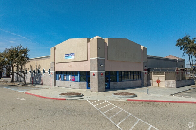
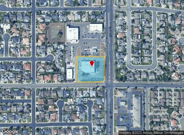
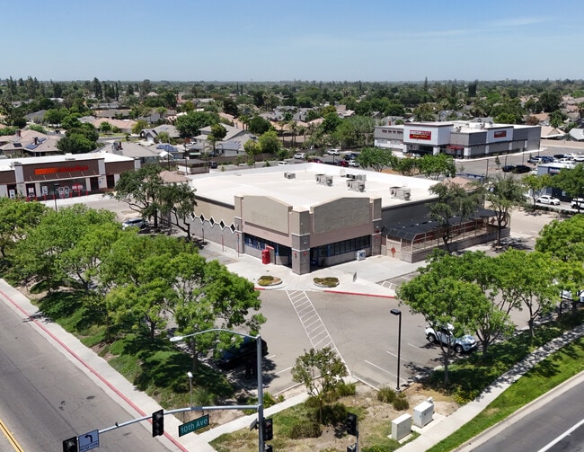
Property Record
2500 N 10Th Ave, Hanford, CA 93230

NEARBY LISTINGS FOR SALE OR LEASE
Property Detail
2500 N 10Th Ave
Hanford-Corcoran, CA
Coelho 421
007-110-051-000
PARCEL B OF PM 15-15 13/18/21
Regionalshoppingcenterormallwithanchorstore
Kings
X
California
06031C0185C
2
2024
1.75 AC
2025
Hanford/Armona
000701
Fresno
16,750 SF
DEMOGRAPHICS near 2500 N 10Th Ave
1 Mile
3 Mile
5 Mile
2024 Total Population
12,559
49,093
68,718
2029 Population
12,768
50,240
70,127
Pop Growth 2024-2029
+ 1.66%
+ 2.34%
+ 2.05%
Average Age
38
36
36
2024 Total Households
4,662
16,866
22,516
HH Growth 2024-2029
+ 1.65%
+ 2.27%
+ 2.04%
Median Household Inc
$84,638
$73,523
$68,793
Avg Household Size
2.70
2.80
3.00
2024 Avg HH Vehicles
2.00
2.00
2.00
Median Home Value
$305,955
$309,293
$302,480
Median Year Built
1986
1986
1986
Nearby Places
Map Layers
Map Styles
 Street
 Aerial
- Restaurants
- Banks
- Shops
- Fitness
- Groceries
PUBLIC TRANSPORTATION
COMMUTER RAIL
DRIVE
WALK
Distance
6 min
3.0 mi
AIRPORT
Fresno Yosemite International
DRIVE
WALK
Distance
Fresno Yosemite International
48 min
31.8 mi
SALE & LEASE HISTORY
LISTING DATE
SALE/LEASE

Sep 23, 2024
For Lease
Sep 23, 2024
For Sale
Nearby Properties
Address
Land Use
TOTAL SIZE
Lot Size
Zoning
Address
Land Use
TOTAL SIZE
Lot Size
Zoning
190,329 SF
27.94 AC
O
Address
Land Use
TOTAL SIZE
Lot Size
Zoning
14.37 AC
O
Address
Land Use
TOTAL SIZE
Lot Size
Zoning
24.69 AC
RM2
Address
Land Use
TOTAL SIZE
Lot Size
Zoning
62,349 SF
1.11 AC
O
Address
Land Use
TOTAL SIZE
Lot Size
Zoning
152,210 SF
8.91 AC
R-M
Address
Land Use
TOTAL SIZE
Lot Size
Zoning
95,040 SF
7.90 AC
RM3
Address
Land Use
TOTAL SIZE
Lot Size
Zoning
149,560 SF
14.25 AC
C-R
Address
Land Use
TOTAL SIZE
Lot Size
Zoning
48,606 SF
0.80 AC
O
Address
Land Use
TOTAL SIZE
Lot Size
Zoning
76,233 SF
13.60 AC
RC
Address
Land Use
TOTAL SIZE
Lot Size
Zoning
93,373 SF
4 AC
NC
Address
Land Use
TOTAL SIZE
Lot Size
Zoning
39,703 SF
0.97 AC
SC
Address
Land Use
TOTAL SIZE
Lot Size
Zoning
127,832 SF
12.64 AC
RC
Address
Land Use
TOTAL SIZE
Lot Size
Zoning
11.56 AC
RM2
Address
Land Use
TOTAL SIZE
Lot Size
Zoning
27,459 SF
1.93 AC
R-M
Address
Land Use
TOTAL SIZE
Lot Size
Zoning
96,199 SF
10.07 AC
RC
Address
Land Use
TOTAL SIZE
Lot Size
Zoning
48,150 SF
2.76 AC
NC
Address
Land Use
TOTAL SIZE
Lot Size
Zoning
2.11 AC
PF
Address
Land Use
TOTAL SIZE
Lot Size
Zoning
58,416 SF
5.46 AC
MXC
Address
Land Use
TOTAL SIZE
Lot Size
Zoning
1,739 SF
29.72 AC
ML
Address
Land Use
TOTAL SIZE
Lot Size
Zoning
14.10 AC
MH
Address
Land Use
TOTAL SIZE
Lot Size
Zoning
2.12 AC
O
Address
Land Use
TOTAL SIZE
Lot Size
Zoning
1.59 AC
R-H
Address
Land Use
TOTAL SIZE
Lot Size
Zoning
41,033 SF
2.18 AC
SC
Address
Land Use
TOTAL SIZE
Lot Size
Zoning
1,626 SF
16.92 AC
SC
Address
Land Use
TOTAL SIZE
Lot Size
Zoning
77,948 SF
6.73 AC
RC
Address
Land Use
TOTAL SIZE
Lot Size
Zoning
34,340 SF
2.40 AC
NC
Address
Land Use
TOTAL SIZE
Lot Size
Zoning
39,542 SF
3.38 AC
CC
Address
Land Use
TOTAL SIZE
Lot Size
Zoning
5.15 AC
R-M
Address
Land Use
TOTAL SIZE
Lot Size
Zoning
40,652 SF
5.86 AC
SC
The World's #1 Commercial Real Estate Marketplace
Connect with us
© 2026 CoStar Group
The information above has been obtained from sources believed reliable. While we do not doubt its accuracy we have not verified it and make no guarantee, warranty or representation about it. It is your responsibility to independently confirm its accuracy and completeness. Any projections, opinions, assumptions, or estimates used are for example only and do not represent the current or future performance of the property. The value of this transaction to you depends on tax and other factors which should be evaluated by your tax, financial, and legal advisors. You and your advisors should conduct a careful, independent investigation of the property to determine to your satisfaction the suitability of the property for your needs.