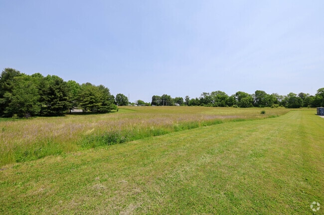
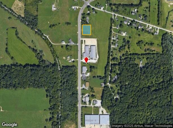
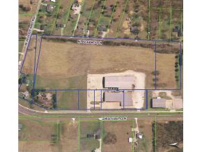
Property Record
2500 N Curry Pike, Bloomington, IN 47404
NEARBY LISTINGS FOR SALE OR LEASE
-
-
-
-
No Photo
-
-
View all Bloomington listings for sale on LoopNet.com
Property Detail
2500 N Curry Pike
Bloomington, IN
Griner Addition
53-04-25-102-011.000-011
GRINER LOT 2
Residentialacreage
Monroe
X
Indiana
18105C0129D
2
2024
0.86 AC
2024
Bloomington/Terre Haute
001301
Other Market Areas
DEMOGRAPHICS near 2500 N Curry Pike
1 Mile
3 Mile
5 Mile
2024 Total Population
1,249
36,773
90,096
2029 Population
1,265
36,843
90,007
Pop Growth 2024-2029
+ 1.28%
+ 0.19%
(0.10%)
Average Age
43
36
34
2024 Total Households
546
16,564
37,261
HH Growth 2024-2029
+ 1.28%
+ 0.11%
(0.11%)
Median Household Inc
$44,166
$43,666
$44,867
Avg Household Size
2.20
2.10
2.10
2024 Avg HH Vehicles
2.00
2.00
2.00
Median Home Value
$87,704
$200,514
$205,205
Median Year Built
1991
1989
1986
Nearby Places
Map Layers
Map Styles
 Street
 Aerial
- Restaurants
- Banks
- Shops
- Fitness
- Groceries
Nearby Properties
Address
Land Use
TOTAL SIZE
Lot Size
Zoning
Address
Land Use
TOTAL SIZE
Lot Size
Zoning
7,804 SF
7.22 AC
Address
Land Use
TOTAL SIZE
Lot Size
Zoning
496,556 SF
1.73 AC
Address
Land Use
TOTAL SIZE
Lot Size
Zoning
13,910 SF
3.86 AC
Address
Land Use
TOTAL SIZE
Lot Size
Zoning
261,278 SF
4.62 AC
Address
Land Use
TOTAL SIZE
Lot Size
Zoning
318,600 SF
43.80 AC
IL
Address
Land Use
TOTAL SIZE
Lot Size
Zoning
10,573 SF
3.28 AC
Address
Land Use
TOTAL SIZE
Lot Size
Zoning
8,064 SF
1.29 AC
Address
Land Use
TOTAL SIZE
Lot Size
Zoning
14,964 SF
12.34 AC
Address
Land Use
TOTAL SIZE
Lot Size
Zoning
19,128 SF
24.44 AC
Address
Land Use
TOTAL SIZE
Lot Size
Zoning
60,434 SF
29.85 AC
IG
Address
Land Use
TOTAL SIZE
Lot Size
Zoning
169,170 SF
0.72 AC
Address
Land Use
TOTAL SIZE
Lot Size
Zoning
8,190 SF
4.22 AC
Address
Land Use
TOTAL SIZE
Lot Size
Zoning
181,798 SF
0.80 AC
Address
Land Use
TOTAL SIZE
Lot Size
Zoning
18,772 SF
2.69 AC
Address
Land Use
TOTAL SIZE
Lot Size
Zoning
53,005 SF
10.03 AC
PUD
Address
Land Use
TOTAL SIZE
Lot Size
Zoning
14,376 SF
11.03 AC
Address
Land Use
TOTAL SIZE
Lot Size
Zoning
1,509 SF
3 AC
Address
Land Use
TOTAL SIZE
Lot Size
Zoning
269,822 SF
27.95 AC
Address
Land Use
TOTAL SIZE
Lot Size
Zoning
38,208 SF
8.03 AC
Address
Land Use
TOTAL SIZE
Lot Size
Zoning
1,120 SF
11.95 AC
Address
Land Use
TOTAL SIZE
Lot Size
Zoning
64,798 SF
18.32 AC
RE1
Address
Land Use
TOTAL SIZE
Lot Size
Zoning
10,573 SF
1.30 AC
Address
Land Use
TOTAL SIZE
Lot Size
Zoning
78,474 SF
0.35 AC
Address
Land Use
TOTAL SIZE
Lot Size
Zoning
119,952 SF
0.82 AC
Address
Land Use
TOTAL SIZE
Lot Size
Zoning
6,120 SF
36.03 AC
Address
Land Use
TOTAL SIZE
Lot Size
Zoning
17,950 SF
12.06 AC
Address
Land Use
TOTAL SIZE
Lot Size
Zoning
11,488 SF
14.33 AC
Address
Land Use
TOTAL SIZE
Lot Size
Zoning
48,022 SF
0.77 AC
Address
Land Use
TOTAL SIZE
Lot Size
Zoning
107,519 SF
0.03 AC
Address
Land Use
TOTAL SIZE
Lot Size
Zoning
64,139 SF
2.82 AC
The World's #1 Commercial Real Estate Marketplace
Connect with us
© 2025 CoStar Group
The information above has been obtained from sources believed reliable. While we do not doubt its accuracy we have not verified it and make no guarantee, warranty or representation about it. It is your responsibility to independently confirm its accuracy and completeness. Any projections, opinions, assumptions, or estimates used are for example only and do not represent the current or future performance of the property. The value of this transaction to you depends on tax and other factors which should be evaluated by your tax, financial, and legal advisors. You and your advisors should conduct a careful, independent investigation of the property to determine to your satisfaction the suitability of the property for your needs.