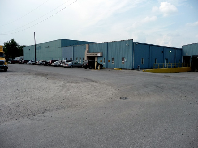
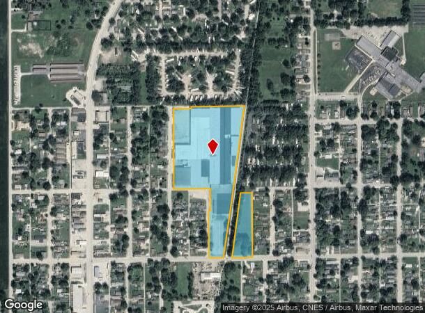
Property Record
2500 N Union St, Kokomo, IN 46901
NEARBY LISTINGS FOR SALE OR LEASE
Property Detail
2500 N Union St
Kokomo, IN
Charles M Steeles Sub
34-03-24-426-002.000-002
CHARLES M STEELES S/D LOTS 212 THRU 239 & LOTS 251 THRU 272 ALSO LOT XX & VAC
Lightindustrial
Howard
X
Indiana
18067C0069C
212-2
2024
12.93 AC
2025
Lafayette/Kokomo
000400
Other Market Areas
21,676 SF
DEMOGRAPHICS near 2500 N Union St
1 Mile
3 Mile
5 Mile
2024 Total Population
7,355
33,889
57,858
2029 Population
7,450
34,328
58,021
Pop Growth 2024-2029
+ 1.29%
+ 1.30%
+ 0.28%
Average Age
39
40
41
2024 Total Households
3,042
14,606
25,399
HH Growth 2024-2029
+ 1.18%
+ 1.26%
+ 0.22%
Median Household Inc
$42,829
$44,225
$49,856
Avg Household Size
2.30
2.20
2.20
2024 Avg HH Vehicles
2.00
2.00
2.00
Median Home Value
$58,343
$86,672
$123,511
Median Year Built
1955
1955
1964
Nearby Places
Map Layers
Map Styles
 Street
 Aerial
- Restaurants
- Banks
- Shops
- Fitness
- Groceries
SALE & LEASE HISTORY
LISTING DATE
SALE/LEASE

Sep 25, 2016
For Lease
May 27, 2025
For Lease
Jan 19, 2017
For Lease
Aug 30, 2017
For Lease
Nearby Properties
Address
Land Use
TOTAL SIZE
Lot Size
Zoning
Address
Land Use
TOTAL SIZE
Lot Size
Zoning
1,642,721 SF
83.45 AC
Address
Land Use
TOTAL SIZE
Lot Size
Zoning
451,898 SF
279.05 AC
Address
Land Use
TOTAL SIZE
Lot Size
Zoning
11,490,970 SF
0.02 AC
Address
Land Use
TOTAL SIZE
Lot Size
Zoning
148,184 SF
21.53 AC
Address
Land Use
TOTAL SIZE
Lot Size
Zoning
27,882 SF
23.48 AC
Address
Land Use
TOTAL SIZE
Lot Size
Zoning
38,390 SF
1.97 AC
Address
Land Use
TOTAL SIZE
Lot Size
Zoning
125,136 SF
22.88 AC
Address
Land Use
TOTAL SIZE
Lot Size
Zoning
45,179 SF
22.36 AC
Address
Land Use
TOTAL SIZE
Lot Size
Zoning
126,690 SF
23.75 AC
Address
Land Use
TOTAL SIZE
Lot Size
Zoning
11,936 SF
1.18 AC
Address
Land Use
TOTAL SIZE
Lot Size
Zoning
5,732 SF
10.96 AC
Address
Land Use
TOTAL SIZE
Lot Size
Zoning
188,016 SF
13.15 AC
Address
Land Use
TOTAL SIZE
Lot Size
Zoning
83,797 SF
8.42 AC
Address
Land Use
TOTAL SIZE
Lot Size
Zoning
60,046 SF
11.36 AC
Address
Land Use
TOTAL SIZE
Lot Size
Zoning
0.01 AC
Address
Land Use
TOTAL SIZE
Lot Size
Zoning
75,440 SF
19.08 AC
Address
Land Use
TOTAL SIZE
Lot Size
Zoning
28,188 SF
13.49 AC
Address
Land Use
TOTAL SIZE
Lot Size
Zoning
26,632 SF
5.80 AC
Address
Land Use
TOTAL SIZE
Lot Size
Zoning
81,291 SF
20.58 AC
Address
Land Use
TOTAL SIZE
Lot Size
Zoning
125,267 SF
15.21 AC
Address
Land Use
TOTAL SIZE
Lot Size
Zoning
58,770 SF
17.64 AC
Address
Land Use
TOTAL SIZE
Lot Size
Zoning
1,386 SF
1.48 AC
Address
Land Use
TOTAL SIZE
Lot Size
Zoning
15,378 SF
2.26 AC
Address
Land Use
TOTAL SIZE
Lot Size
Zoning
26,143 SF
11.06 AC
Address
Land Use
TOTAL SIZE
Lot Size
Zoning
3,920 SF
24.97 AC
Address
Land Use
TOTAL SIZE
Lot Size
Zoning
114,512 SF
11.38 AC
Address
Land Use
TOTAL SIZE
Lot Size
Zoning
76.03 AC
Address
Land Use
TOTAL SIZE
Lot Size
Zoning
22,094 SF
5.03 AC
Address
Land Use
TOTAL SIZE
Lot Size
Zoning
11,400 SF
5.52 AC
Address
Land Use
TOTAL SIZE
Lot Size
Zoning
50,200 SF
10.52 AC
The World's #1 Commercial Real Estate Marketplace
Connect with us
© 2025 CoStar Group
The information above has been obtained from sources believed reliable. While we do not doubt its accuracy we have not verified it and make no guarantee, warranty or representation about it. It is your responsibility to independently confirm its accuracy and completeness. Any projections, opinions, assumptions, or estimates used are for example only and do not represent the current or future performance of the property. The value of this transaction to you depends on tax and other factors which should be evaluated by your tax, financial, and legal advisors. You and your advisors should conduct a careful, independent investigation of the property to determine to your satisfaction the suitability of the property for your needs.