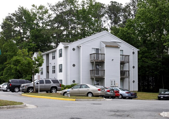
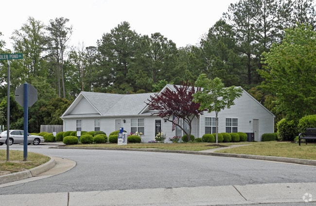
Property Record
2500 Sadler Pond Dr, Suffolk, VA 23434

NEARBY LISTINGS FOR SALE OR LEASE
-
-
View all Suffolk listings for sale on LoopNet.com
Property Detail
2500 Sadler Pond Dr
Virginia Beach-Chesapeake-Norfolk, VA-NC
Pump Station Site
253211000
PHASE I., SADLER POND
Multifamilydwelling
Suffolk City
X
Virginia
51093C0300E
5.70 AC
2025
Suffolk City County
2025
Hampton Roads
065200
DEMOGRAPHICS near 2500 Sadler Pond Dr
1 Mile
3 Mile
5 Mile
2024 Total Population
5,025
26,607
51,507
2029 Population
5,674
29,877
57,518
Pop Growth 2024-2029
+ 12.92%
+ 12.29%
+ 11.67%
Average Age
38
39
39
2024 Total Households
1,754
9,894
19,374
HH Growth 2024-2029
+ 13.63%
+ 12.75%
+ 12.05%
Median Household Inc
$79,471
$79,489
$69,271
Avg Household Size
2.60
2.60
2.60
2024 Avg HH Vehicles
2.00
2.00
2.00
Median Home Value
$276,102
$283,521
$262,601
Median Year Built
2005
1995
1988
Nearby Places
Map Layers
Map Styles
 Street
 Aerial
- Restaurants
- Banks
- Shops
- Fitness
- Groceries
PUBLIC TRANSPORTATION
AIRPORT
Norfolk International
DRIVE
WALK
Distance
Norfolk International
41 min
27.5 mi
Newport News/Williamsburg International
DRIVE
WALK
Distance
Newport News/Williamsburg International
51 min
33.6 mi
Freight Ports
Virginia Port Authority - Portsmouth
DRIVE
WALK
Distance
Virginia Port Authority - Portsmouth
31 min
20.4 mi
Nearby Properties
Address
Land Use
TOTAL SIZE
Lot Size
Zoning
Address
Land Use
TOTAL SIZE
Lot Size
Zoning
10,850 SF
51.12 AC
GENERAL CO
Address
Land Use
TOTAL SIZE
Lot Size
Zoning
49,292 SF
9 AC
GENERAL CO
Address
Land Use
TOTAL SIZE
Lot Size
Zoning
56,994 SF
12.84 AC
PLANNED DE
Address
Land Use
TOTAL SIZE
Lot Size
Zoning
5,617 SF
16.96 AC
MIXED USE
Address
Land Use
TOTAL SIZE
Lot Size
Zoning
388,200 SF
27.99 AC
LIGHT INDU
Address
Land Use
TOTAL SIZE
Lot Size
Zoning
275,292 SF
79.88 AC
COMMERCE P
Address
Land Use
TOTAL SIZE
Lot Size
Zoning
1,922 SF
169.84 AC
RESIDENTIA
Address
Land Use
TOTAL SIZE
Lot Size
Zoning
13.21 AC
OFFICE-INS
Address
Land Use
TOTAL SIZE
Lot Size
Zoning
19.66 AC
RES LOW-ME
Address
Land Use
TOTAL SIZE
Lot Size
Zoning
9.02 AC
PLANNED DE
Address
Land Use
TOTAL SIZE
Lot Size
Zoning
4,928 SF
20.79 AC
GENERAL CO
Address
Land Use
TOTAL SIZE
Lot Size
Zoning
2,443.35 AC
CONSERVATI
Address
Land Use
TOTAL SIZE
Lot Size
Zoning
97,713 SF
15.22 AC
PLANNED DE
Address
Land Use
TOTAL SIZE
Lot Size
Zoning
92.63 AC
GENERAL CO
Address
Land Use
TOTAL SIZE
Lot Size
Zoning
91,512 SF
0.35 AC
CENTRAL BU
Address
Land Use
TOTAL SIZE
Lot Size
Zoning
131,990 SF
31.40 AC
RURAL RESI
Address
Land Use
TOTAL SIZE
Lot Size
Zoning
1,470 SF
6.69 AC
GENERAL CO
Address
Land Use
TOTAL SIZE
Lot Size
Zoning
12,457 SF
27.01 AC
GENERAL CO
Address
Land Use
TOTAL SIZE
Lot Size
Zoning
91,050 SF
17.06 AC
HEAVY INDU
Address
Land Use
TOTAL SIZE
Lot Size
Zoning
115,088 SF
0.17 AC
CENTRAL BU
Address
Land Use
TOTAL SIZE
Lot Size
Zoning
24,371 SF
1,757.56 AC
CONSERVATI
Address
Land Use
TOTAL SIZE
Lot Size
Zoning
73,277 SF
1.94 AC
CENTRAL BU
Address
Land Use
TOTAL SIZE
Lot Size
Zoning
14,361 SF
93.92 AC
OFFICE-INS
Address
Land Use
TOTAL SIZE
Lot Size
Zoning
37.97 AC
PLANNED DE
Address
Land Use
TOTAL SIZE
Lot Size
Zoning
32,040 SF
13 AC
OFFICE-INS
Address
Land Use
TOTAL SIZE
Lot Size
Zoning
5,000 SF
5.92 AC
GENERAL CO
The World's #1 Commercial Real Estate Marketplace
Connect with us
© 2026 CoStar Group
The information above has been obtained from sources believed reliable. While we do not doubt its accuracy we have not verified it and make no guarantee, warranty or representation about it. It is your responsibility to independently confirm its accuracy and completeness. Any projections, opinions, assumptions, or estimates used are for example only and do not represent the current or future performance of the property. The value of this transaction to you depends on tax and other factors which should be evaluated by your tax, financial, and legal advisors. You and your advisors should conduct a careful, independent investigation of the property to determine to your satisfaction the suitability of the property for your needs.