Property Record
2500 Towergate Ct, Winston Salem, NC 27106
NEARBY LISTINGS FOR SALE OR LEASE
-
-
View all Winston Salem listings for sale on LoopNet.com
Property Detail
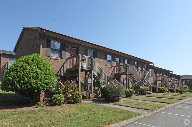
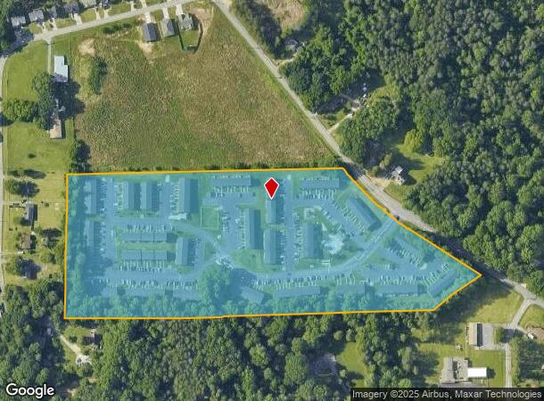
2500 Towergate Ct
Winston-Salem, NC
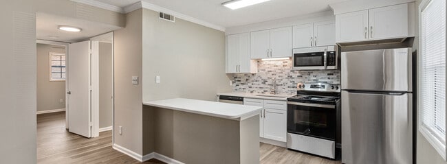
The Flats At Salem Apts
6818-21-4034
THE FLATS AT SALEM APTS LO:101 BL:3461B BU:1
Apartment
Forsyth
X
North Carolina
3710681800J
101
2024
14.65 AC
2025
Bethabara Estates
002701
Greensboro/Winston-Salem
89,957 SF
DEMOGRAPHICS near 2500 Towergate Ct
1 Mile
3 Mile
5 Mile
2024 Total Population
7,918
49,362
103,698
2029 Population
8,244
51,295
108,037
Pop Growth 2024-2029
+ 4.12%
+ 3.92%
+ 4.18%
Average Age
37
38
39
2024 Total Households
3,136
19,820
40,897
HH Growth 2024-2029
+ 4.11%
+ 4.03%
+ 4.27%
Median Household Inc
$52,376
$56,791
$63,205
Avg Household Size
2.40
2.30
2.40
2024 Avg HH Vehicles
2.00
2.00
2.00
Median Home Value
$157,514
$206,664
$237,931
Median Year Built
1985
1983
1980
Nearby Places
Map Layers
Map Styles
 Street
 Aerial
- Restaurants
- Banks
- Shops
- Fitness
- Groceries
PUBLIC TRANSPORTATION
AIRPORT
Piedmont Triad International
DRIVE
WALK
Distance
Piedmont Triad International
46 min
28.1 mi
Freight Ports
Virginia Port Authority - Richmond
DRIVE
WALK
Distance
Virginia Port Authority - Richmond
273 min
231.7 mi
Nearby Properties
Address
Land Use
TOTAL SIZE
Lot Size
Zoning
Address
Land Use
TOTAL SIZE
Lot Size
Zoning
100 SF
213.71 AC
C
Address
Land Use
TOTAL SIZE
Lot Size
Zoning
329,963 SF
58.84 AC
RM18-S
Address
Land Use
TOTAL SIZE
Lot Size
Zoning
153,937 SF
34.63 AC
RM12-S
Address
Land Use
TOTAL SIZE
Lot Size
Zoning
160,210 SF
33.21 AC
AG
Address
Land Use
TOTAL SIZE
Lot Size
Zoning
245,828 SF
28.02 AC
GB
Address
Land Use
TOTAL SIZE
Lot Size
Zoning
188,135 SF
8.65 AC
GO-S
Address
Land Use
TOTAL SIZE
Lot Size
Zoning
152,968 SF
32.40 AC
RM18
Address
Land Use
TOTAL SIZE
Lot Size
Zoning
127,566 SF
35.86 AC
C-L
Address
Land Use
TOTAL SIZE
Lot Size
Zoning
85,354 SF
29.13 AC
RM18-S
Address
Land Use
TOTAL SIZE
Lot Size
Zoning
178,192 SF
28.15 AC
RM18
Address
Land Use
TOTAL SIZE
Lot Size
Zoning
91,905 SF
21.18 AC
RM18-S
Address
Land Use
TOTAL SIZE
Lot Size
Zoning
106,821 SF
14.95 AC
RM12-S
Address
Land Use
TOTAL SIZE
Lot Size
Zoning
224,895 SF
31.67 AC
HB-S
Address
Land Use
TOTAL SIZE
Lot Size
Zoning
209,521 SF
20.73 AC
HB-S,RS9
Address
Land Use
TOTAL SIZE
Lot Size
Zoning
741,857 SF
53.71 AC
GB-L
Address
Land Use
TOTAL SIZE
Lot Size
Zoning
12,132 SF
57.50 AC
RM18
Address
Land Use
TOTAL SIZE
Lot Size
Zoning
711,274 SF
38.24 AC
LI
Address
Land Use
TOTAL SIZE
Lot Size
Zoning
120,256 SF
43.62 AC
GB-S,IP
Address
Land Use
TOTAL SIZE
Lot Size
Zoning
90,740 SF
17.28 AC
RM18
Address
Land Use
TOTAL SIZE
Lot Size
Zoning
106,941 SF
10.91 AC
RM12-S
Address
Land Use
TOTAL SIZE
Lot Size
Zoning
82,843 SF
16.06 AC
RM18
Address
Land Use
TOTAL SIZE
Lot Size
Zoning
111,873 SF
23.10 AC
RM18
Address
Land Use
TOTAL SIZE
Lot Size
Zoning
120,118 SF
15.71 AC
RM18
Address
Land Use
TOTAL SIZE
Lot Size
Zoning
141,377 SF
37.07 AC
IP
Address
Land Use
TOTAL SIZE
Lot Size
Zoning
99,460 SF
17.17 AC
RM18
Address
Land Use
TOTAL SIZE
Lot Size
Zoning
72,782 SF
15.72 AC
RM12-S,RS9
Address
Land Use
TOTAL SIZE
Lot Size
Zoning
67,643 SF
19.19 AC
RM12-S
Address
Land Use
TOTAL SIZE
Lot Size
Zoning
113,060 SF
16.61 AC
HB-S,RS9
Address
Land Use
TOTAL SIZE
Lot Size
Zoning
34,316 SF
6.50 AC
GB
Address
Land Use
TOTAL SIZE
Lot Size
Zoning
92,721 SF
22.79 AC
HB
The World's #1 Commercial Real Estate Marketplace
Connect with us
© 2025 CoStar Group
The information above has been obtained from sources believed reliable. While we do not doubt its accuracy we have not verified it and make no guarantee, warranty or representation about it. It is your responsibility to independently confirm its accuracy and completeness. Any projections, opinions, assumptions, or estimates used are for example only and do not represent the current or future performance of the property. The value of this transaction to you depends on tax and other factors which should be evaluated by your tax, financial, and legal advisors. You and your advisors should conduct a careful, independent investigation of the property to determine to your satisfaction the suitability of the property for your needs.