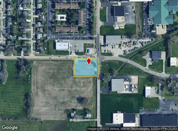
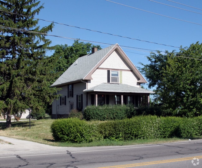
Property Record
2500 Tracy Rd, Northwood, OH 43619

NEARBY LISTINGS FOR SALE OR LEASE
Property Detail
2500 Tracy Rd
Toledo, OH
United States Reserve
M50-300-240000001000
USR 03 24 NE COR E 10A N 1/2 NENE
Commercialacreage
Wood
2023
Ohio
2024
1 AC
020100
Perrysburg/Northwood
1,337 SF
Toledo
DEMOGRAPHICS near 2500 Tracy Rd
1 Mile
3 Mile
5 Mile
2024 Total Population
3,511
52,856
145,489
2029 Population
3,527
53,210
146,332
Pop Growth 2024-2029
+ 0.46%
+ 0.67%
+ 0.58%
Average Age
39
38
39
2024 Total Households
1,454
22,155
61,913
HH Growth 2024-2029
+ 0.28%
+ 0.60%
+ 0.51%
Median Household Inc
$46,666
$42,316
$40,814
Avg Household Size
2.40
2.30
2.20
2024 Avg HH Vehicles
2.00
2.00
1.00
Median Home Value
$100,899
$93,682
$100,365
Median Year Built
1954
1949
1952
Nearby Places
Map Layers
Map Styles
 Street
 Aerial
- Restaurants
- Banks
- Shops
- Fitness
- Groceries
PUBLIC TRANSPORTATION
COMMUTER RAIL
DRIVE
WALK
Distance
8 min
3.8 mi
AIRPORT
Eugene F Kranz Toledo Express
DRIVE
WALK
Distance
Eugene F Kranz Toledo Express
36 min
22.2 mi
Freight Ports
DRIVE
WALK
Distance
17 min
7.3 mi
Nearby Properties
Address
Land Use
TOTAL SIZE
Lot Size
Zoning
Address
Land Use
TOTAL SIZE
Lot Size
Zoning
1,243,593 SF
42.25 AC
10-MX
Address
Land Use
TOTAL SIZE
Lot Size
Zoning
605,609 SF
9.66 AC
40-C4
Address
Land Use
TOTAL SIZE
Lot Size
Zoning
277,862 SF
3 AC
10-CD
Address
Land Use
TOTAL SIZE
Lot Size
Zoning
1,081,340 SF
76.95 AC
Address
Land Use
TOTAL SIZE
Lot Size
Zoning
504,154 SF
111.51 AC
Address
Land Use
TOTAL SIZE
Lot Size
Zoning
598,713 SF
59.75 AC
Address
Land Use
TOTAL SIZE
Lot Size
Zoning
314,826 SF
10.28 AC
10-CM
Address
Land Use
TOTAL SIZE
Lot Size
Zoning
313,004 SF
44.54 AC
40-C2
Address
Land Use
TOTAL SIZE
Lot Size
Zoning
111,471 SF
6.17 AC
10-CD
Address
Land Use
TOTAL SIZE
Lot Size
Zoning
496,062 SF
50.37 AC
Address
Land Use
TOTAL SIZE
Lot Size
Zoning
1.74 AC
10-CD
Address
Land Use
TOTAL SIZE
Lot Size
Zoning
243,165 SF
3.63 AC
10-CD
Address
Land Use
TOTAL SIZE
Lot Size
Zoning
219,265 SF
32.11 AC
Address
Land Use
TOTAL SIZE
Lot Size
Zoning
176,125 SF
21.61 AC
Address
Land Use
TOTAL SIZE
Lot Size
Zoning
174,496 SF
7.30 AC
Address
Land Use
TOTAL SIZE
Lot Size
Zoning
14,824 SF
54.18 AC
10-MX
Address
Land Use
TOTAL SIZE
Lot Size
Zoning
136,090 SF
4 AC
Address
Land Use
TOTAL SIZE
Lot Size
Zoning
211,050 SF
13.19 AC
Address
Land Use
TOTAL SIZE
Lot Size
Zoning
127,658 SF
9.01 AC
40-C4
Address
Land Use
TOTAL SIZE
Lot Size
Zoning
184,765 SF
12.91 AC
Address
Land Use
TOTAL SIZE
Lot Size
Zoning
486,615 SF
45.39 AC
Address
Land Use
TOTAL SIZE
Lot Size
Zoning
316,351 SF
30.65 AC
10-IC
Address
Land Use
TOTAL SIZE
Lot Size
Zoning
392,037 SF
21.94 AC
Address
Land Use
TOTAL SIZE
Lot Size
Zoning
370,650 SF
13.65 AC
10-MX
Address
Land Use
TOTAL SIZE
Lot Size
Zoning
273,871 SF
0.66 AC
10-CD
Address
Land Use
TOTAL SIZE
Lot Size
Zoning
3.22 AC
10-CD
Address
Land Use
TOTAL SIZE
Lot Size
Zoning
Address
Land Use
TOTAL SIZE
Lot Size
Zoning
1.01 AC
10-CD
Address
Land Use
TOTAL SIZE
Lot Size
Zoning
170,760 SF
51.98 AC
Address
Land Use
TOTAL SIZE
Lot Size
Zoning
225,918 SF
17.15 AC
The World's #1 Commercial Real Estate Marketplace
Connect with us
© 2025 CoStar Group
The information above has been obtained from sources believed reliable. While we do not doubt its accuracy we have not verified it and make no guarantee, warranty or representation about it. It is your responsibility to independently confirm its accuracy and completeness. Any projections, opinions, assumptions, or estimates used are for example only and do not represent the current or future performance of the property. The value of this transaction to you depends on tax and other factors which should be evaluated by your tax, financial, and legal advisors. You and your advisors should conduct a careful, independent investigation of the property to determine to your satisfaction the suitability of the property for your needs.