Property Record
2500 Troy Rd, Edwardsville, IL 62025


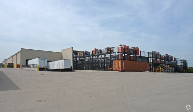
Property Detail
2500 Troy Rd
St. Louis, MO-IL
THE HOME DEPOT SUBDIVISION PART LOT 1 1160.93 X 1206.09 IRREGULAR
14-2-15-23-00-000-062
Madison
Wholesaleoutletdiscountstore
Illinois
2025
1
2025
12.29 AC
403122
NE Metro Illinois
94,310 SF
St. Louis
NEARBY LISTINGS FOR SALE OR LEASE
DEMOGRAPHICS near 2500 Troy Rd
1 mile
3 mile
5 mile
2025 Total Population
8,446
37,931
62,537
2030 Population
8,300
37,645
62,137
Pop Growth 2025-2030
(1.73%)
(0.75%)
(0.64%)
Average Age
39
39
40
2025 Total Households
3,166
14,383
23,574
HH Growth 2025-2030
(1.86%)
(0.80%)
(0.70%)
Median Household Inc
$116,902
$98,908
$100,847
Avg Household Size
2.60
2.40
2.40
2025 Avg HH Vehicles
2.00
2.00
2.00
Median Home Value
$340,206
$312,230
$292,470
Median Year Built
1994
1986
1988
Nearby Places
Map Layers
Map Styles
 Street
 Aerial
Layers
 Traffic
 Biking
Places
Listings with unknown addresses are not visible on the map
- Restaurants
- Banks
- Shops
- Fitness
- Groceries
PUBLIC TRANSPORTATION
AIRPORT
St Louis Lambert International
Drive
Walk
Distance
St Louis Lambert International
35 min
25.5 mi
Scott AFB/Midamerica St Louis
Drive
Walk
Distance
Scott AFB/Midamerica St Louis
43 min
26.3 mi
Freight Ports
Port Milwaukee
Drive
Walk
Distance
Port Milwaukee
395 min
350.3 mi
Nearby Properties
Address
Land Use
TOTAL SIZE
Lot Size
Zoning
Address
Land Use
TOTAL SIZE
Lot Size
Zoning
149,417 SF
26.44 AC
Address
Land Use
TOTAL SIZE
Lot Size
Zoning
4.40 AC
Address
Land Use
TOTAL SIZE
Lot Size
Zoning
75,367 SF
12.25 AC
Address
Land Use
TOTAL SIZE
Lot Size
Zoning
56,126 SF
10 AC
Address
Land Use
TOTAL SIZE
Lot Size
Zoning
28,164 SF
9.31 AC
Address
Land Use
TOTAL SIZE
Lot Size
Zoning
126,578 SF
3.74 AC
Address
Land Use
TOTAL SIZE
Lot Size
Zoning
433,512 SF
44.55 AC
Address
Land Use
TOTAL SIZE
Lot Size
Zoning
117,072 SF
2.90 AC
Address
Land Use
TOTAL SIZE
Lot Size
Zoning
374,400 SF
32.15 AC
Address
Land Use
TOTAL SIZE
Lot Size
Zoning
3,209 SF
8.62 AC
Address
Land Use
TOTAL SIZE
Lot Size
Zoning
218,837 SF
4.81 AC
Address
Land Use
TOTAL SIZE
Lot Size
Zoning
50,968 SF
4.23 AC
Address
Land Use
TOTAL SIZE
Lot Size
Zoning
16,274 SF
19.78 AC
Address
Land Use
TOTAL SIZE
Lot Size
Zoning
22,486 SF
2.69 AC
Address
Land Use
TOTAL SIZE
Lot Size
Zoning
190,744 SF
12.47 AC
Address
Land Use
TOTAL SIZE
Lot Size
Zoning
2,724 SF
11.26 AC
Address
Land Use
TOTAL SIZE
Lot Size
Zoning
85,519 SF
10.09 AC
Address
Land Use
TOTAL SIZE
Lot Size
Zoning
58,359 SF
5 AC
Address
Land Use
TOTAL SIZE
Lot Size
Zoning
77,411 SF
9.11 AC
Address
Land Use
TOTAL SIZE
Lot Size
Zoning
53,192 SF
1.10 AC
Address
Land Use
TOTAL SIZE
Lot Size
Zoning
127,592 SF
11.63 AC
Address
Land Use
TOTAL SIZE
Lot Size
Zoning
12.02 AC
Address
Land Use
TOTAL SIZE
Lot Size
Zoning
131,853 SF
14.60 AC
Address
Land Use
TOTAL SIZE
Lot Size
Zoning
55,292 SF
13.31 AC
Address
Land Use
TOTAL SIZE
Lot Size
Zoning
37,432 SF
2 AC
Address
Land Use
TOTAL SIZE
Lot Size
Zoning
33,495 SF
0.72 AC
Address
Land Use
TOTAL SIZE
Lot Size
Zoning
56,935 SF
0.61 AC
Address
Land Use
TOTAL SIZE
Lot Size
Zoning
30,968 SF
6.32 AC
Address
Land Use
TOTAL SIZE
Lot Size
Zoning
57,114 SF
1.57 AC
Address
Land Use
TOTAL SIZE
Lot Size
Zoning
70,484 SF
9.26 AC
The World's #1 Commercial Real Estate Marketplace
Connect with us
© 2026 CoStar Group
The information above has been obtained from sources believed reliable. While we do not doubt its accuracy we have not verified it and make no guarantee, warranty or representation about it. It is your responsibility to independently confirm its accuracy and completeness. Any projections, opinions, assumptions, or estimates used are for example only and do not represent the current or future performance of the property. The value of this transaction to you depends on tax and other factors which should be evaluated by your tax, financial, and legal advisors. You and your advisors should conduct a careful, independent investigation of the property to determine to your satisfaction the suitability of the property for your needs.