Property Record
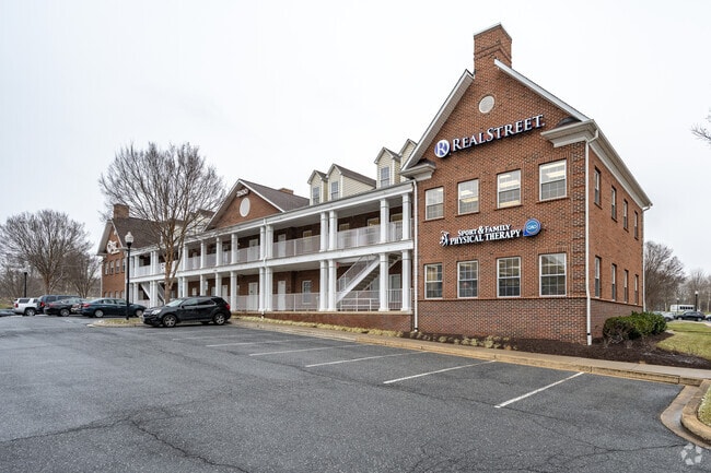
2301 Warwick Way, Marriottsville, MD 21104


Current Lease Availabilities
NEARBY LISTINGS FOR SALE OR LEASE
Property Detail
2301 Warwick Way
Baltimore-Columbia-Towson, MD
Waverly Park Comm Condo
03-327418
LAND UNIT A, 1.404 2301 WARWICK WAY TAYLOR TOWER LAND CONDO
Commercialacreage
Howard
X
Maryland
24013C0425D
un a
2024
1.40 AC
2025
Ellicott City
603001
Baltimore
DEMOGRAPHICS near 2301 Warwick Way
1 Mile
3 Mile
5 Mile
2024 Total Population
6,863
24,586
63,054
2029 Population
7,050
25,247
64,659
Pop Growth 2024-2029
+ 2.72%
+ 2.69%
+ 2.55%
Average Age
45
43
42
2024 Total Households
2,502
8,307
21,526
HH Growth 2024-2029
+ 2.64%
+ 2.68%
+ 2.63%
Median Household Inc
$132,790
$154,729
$146,180
Avg Household Size
2.70
2.90
2.90
2024 Avg HH Vehicles
2.00
2.00
2.00
Median Home Value
$688,676
$718,972
$694,820
Median Year Built
2005
1997
1988
Nearby Places
Map Layers
Map Styles
 Street
 Aerial
- Restaurants
- Banks
- Shops
- Fitness
- Groceries
PUBLIC TRANSPORTATION
AIRPORT
Baltimore/Washington International Thurgood Marshall
DRIVE
WALK
Distance
Baltimore/Washington International Thurgood Marshall
30 min
20.1 mi
Freight Ports
Port of Baltimore
DRIVE
WALK
Distance
Port of Baltimore
31 min
20.6 mi
Nearby Properties
Address
Land Use
TOTAL SIZE
Lot Size
Zoning
Address
Land Use
TOTAL SIZE
Lot Size
Zoning
310,700 SF
35.82 AC
RRDEO
Address
Land Use
TOTAL SIZE
Lot Size
Zoning
58,644 SF
31.75 AC
B2
Address
Land Use
TOTAL SIZE
Lot Size
Zoning
15,128 SF
10.21 AC
RA15
Address
Land Use
TOTAL SIZE
Lot Size
Zoning
7,292 SF
663.85 AC
RC2
Address
Land Use
TOTAL SIZE
Lot Size
Zoning
793.07 AC
RCDEO
Address
Land Use
TOTAL SIZE
Lot Size
Zoning
78,366 SF
43.23 AC
RCDEO
Address
Land Use
TOTAL SIZE
Lot Size
Zoning
48,654 SF
11.36 AC
PGCC
Address
Land Use
TOTAL SIZE
Lot Size
Zoning
106,736 SF
30.05 AC
RRDEO
Address
Land Use
TOTAL SIZE
Lot Size
Zoning
8,208 SF
5.09 AC
RA15
Address
Land Use
TOTAL SIZE
Lot Size
Zoning
14,328 SF
14.18 AC
PGCC
Address
Land Use
TOTAL SIZE
Lot Size
Zoning
100,256 SF
16.29 AC
R20
Address
Land Use
TOTAL SIZE
Lot Size
Zoning
52,280 SF
10.02 AC
B1PEC
Address
Land Use
TOTAL SIZE
Lot Size
Zoning
45,823 SF
38.23 AC
RCDEO
Address
Land Use
TOTAL SIZE
Lot Size
Zoning
10,800 SF
5.48 AC
B2
Address
Land Use
TOTAL SIZE
Lot Size
Zoning
37,350 SF
6.05 AC
PGCC
Address
Land Use
TOTAL SIZE
Lot Size
Zoning
58,430 SF
40.40 AC
R20
Address
Land Use
TOTAL SIZE
Lot Size
Zoning
76,260 SF
3 AC
RCDEO
Address
Land Use
TOTAL SIZE
Lot Size
Zoning
13,780 SF
239.78 AC
RCDEO
Address
Land Use
TOTAL SIZE
Lot Size
Zoning
79,464 SF
1.71 AC
PGCC
Address
Land Use
TOTAL SIZE
Lot Size
Zoning
79,464 SF
1.94 AC
PGCC
Address
Land Use
TOTAL SIZE
Lot Size
Zoning
79,464 SF
1.69 AC
PGCC
Address
Land Use
TOTAL SIZE
Lot Size
Zoning
55,557 SF
20.95 AC
PGCC
Address
Land Use
TOTAL SIZE
Lot Size
Zoning
79,464 SF
2.10 AC
PGCC
Address
Land Use
TOTAL SIZE
Lot Size
Zoning
1,680 SF
74.35 AC
RCDEO
Address
Land Use
TOTAL SIZE
Lot Size
Zoning
14,550 SF
1 AC
B2
Address
Land Use
TOTAL SIZE
Lot Size
Zoning
49,600 SF
5.74 AC
RRDEO
Address
Land Use
TOTAL SIZE
Lot Size
Zoning
36,361 SF
6.07 AC
RRDEO
Address
Land Use
TOTAL SIZE
Lot Size
Zoning
4,022 SF
159.55 AC
RCDEO
Address
Land Use
TOTAL SIZE
Lot Size
Zoning
15,100 SF
2.72 AC
B1
Address
Land Use
TOTAL SIZE
Lot Size
Zoning
38,550 SF
3.08 AC
B2
The World's #1 Commercial Real Estate Marketplace
Connect with us
© 2026 CoStar Group
The information above has been obtained from sources believed reliable. While we do not doubt its accuracy we have not verified it and make no guarantee, warranty or representation about it. It is your responsibility to independently confirm its accuracy and completeness. Any projections, opinions, assumptions, or estimates used are for example only and do not represent the current or future performance of the property. The value of this transaction to you depends on tax and other factors which should be evaluated by your tax, financial, and legal advisors. You and your advisors should conduct a careful, independent investigation of the property to determine to your satisfaction the suitability of the property for your needs.