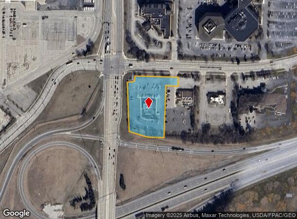
Property Record
25061 Country Club Blvd, North Olmsted, OH 44070
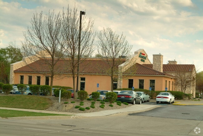
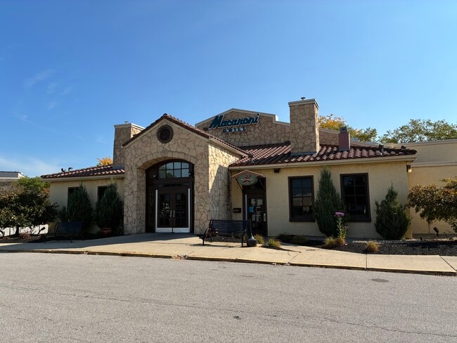

This Property Is For Sale
NEARBY LISTINGS FOR SALE OR LEASE
Property Detail
25061 Country Club Blvd
Cleveland-Elyria, OH
Assembly Plat
236-13-015
SL 1A VOL 275 PG 11 MISSED IN 1996 S/R FF 380.37 D 368.90 1.9107 AC OL TR 6 29/30 2005 S/R MB236 PG13 MB00000 PG0000 MB327 PG96
Restaurantbuilding
Cuyahoga
X
Ohio
39035C0142E
1
2024
1.91 AC
2024
West
174205
Cleveland
5,613 SF
DEMOGRAPHICS near 25061 Country Club Blvd
1 Mile
3 Mile
5 Mile
2024 Total Population
8,037
60,723
172,763
2029 Population
7,786
58,973
168,729
Pop Growth 2024-2029
(3.12%)
(2.88%)
(2.33%)
Average Age
42
44
44
2024 Total Households
3,795
25,760
73,882
HH Growth 2024-2029
(3.37%)
(3.05%)
(2.52%)
Median Household Inc
$57,572
$79,092
$78,197
Avg Household Size
2.10
2.30
2.20
2024 Avg HH Vehicles
2.00
2.00
2.00
Median Home Value
$172,557
$195,517
$206,220
Median Year Built
1966
1966
1967
Nearby Places
- Restaurants
- Banks
- Shops
- Fitness
- Groceries
PUBLIC TRANSPORTATION
AIRPORT
Cleveland-Hopkins International
DRIVE
WALK
Distance
Cleveland-Hopkins International
9 min
3.4 mi
Freight Ports
Port of Toledo
DRIVE
WALK
Distance
Port of Toledo
117 min
99.1 mi
Nearby Properties
Address
Land Use
TOTAL SIZE
Lot Size
Zoning
Address
Land Use
TOTAL SIZE
Lot Size
Zoning
748.88 AC
GI
Address
Land Use
TOTAL SIZE
Lot Size
Zoning
1,669,041 SF
169.42 AC
U6
Address
Land Use
TOTAL SIZE
Lot Size
Zoning
327,732 SF
57.22 AC
1F
Address
Land Use
TOTAL SIZE
Lot Size
Zoning
321,868 SF
71.81 AC
Address
Land Use
TOTAL SIZE
Lot Size
Zoning
154,058 SF
29.97 AC
Address
Land Use
TOTAL SIZE
Lot Size
Zoning
457,220 SF
41.84 AC
CRG
Address
Land Use
TOTAL SIZE
Lot Size
Zoning
126,640 SF
93.63 AC
Address
Land Use
TOTAL SIZE
Lot Size
Zoning
633,719 SF
17.16 AC
CRG
Address
Land Use
TOTAL SIZE
Lot Size
Zoning
195,990 SF
46.88 AC
RMF-A
Address
Land Use
TOTAL SIZE
Lot Size
Zoning
1,391,445 SF
136.05 AC
GI
Address
Land Use
TOTAL SIZE
Lot Size
Zoning
14.60 AC
1F-4
Address
Land Use
TOTAL SIZE
Lot Size
Zoning
193,858 SF
19.65 AC
R-MF24
Address
Land Use
TOTAL SIZE
Lot Size
Zoning
90,324 SF
6.71 AC
GR
Address
Land Use
TOTAL SIZE
Lot Size
Zoning
64,528 SF
17.67 AC
1F-4
Address
Land Use
TOTAL SIZE
Lot Size
Zoning
176,857 SF
8.62 AC
B-2
Address
Land Use
TOTAL SIZE
Lot Size
Zoning
102,512 SF
5.17 AC
CR
Address
Land Use
TOTAL SIZE
Lot Size
Zoning
130,030 SF
5.69 AC
RMF-A
Address
Land Use
TOTAL SIZE
Lot Size
Zoning
37,464 SF
11.14 AC
Address
Land Use
TOTAL SIZE
Lot Size
Zoning
68,600 SF
58.22 AC
U6
Address
Land Use
TOTAL SIZE
Lot Size
Zoning
93,595 SF
7.46 AC
MFS
Address
Land Use
TOTAL SIZE
Lot Size
Zoning
19,614 SF
353.71 AC
1F-4
Address
Land Use
TOTAL SIZE
Lot Size
Zoning
185,847 SF
17.72 AC
CRG
Address
Land Use
TOTAL SIZE
Lot Size
Zoning
163,501 SF
9.88 AC
CRG
Address
Land Use
TOTAL SIZE
Lot Size
Zoning
122,876 SF
5.74 AC
RT
Address
Land Use
TOTAL SIZE
Lot Size
Zoning
174,721 SF
15.60 AC
Address
Land Use
TOTAL SIZE
Lot Size
Zoning
179,879 SF
5.34 AC
RMF-A
Address
Land Use
TOTAL SIZE
Lot Size
Zoning
93,996 SF
4.18 AC
GR
Address
Land Use
TOTAL SIZE
Lot Size
Zoning
198,608 SF
10.03 AC
GI
Address
Land Use
TOTAL SIZE
Lot Size
Zoning
330,163 SF
5.06 AC
MRC2
Address
Land Use
TOTAL SIZE
Lot Size
Zoning
208,960 SF
10.51 AC
MF-MD
The World's #1 Commercial Real Estate Marketplace
Connect with us
© 2025 CoStar Group
The information above has been obtained from sources believed reliable. While we do not doubt its accuracy we have not verified it and make no guarantee, warranty or representation about it. It is your responsibility to independently confirm its accuracy and completeness. Any projections, opinions, assumptions, or estimates used are for example only and do not represent the current or future performance of the property. The value of this transaction to you depends on tax and other factors which should be evaluated by your tax, financial, and legal advisors. You and your advisors should conduct a careful, independent investigation of the property to determine to your satisfaction the suitability of the property for your needs.