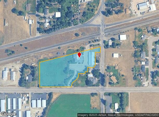
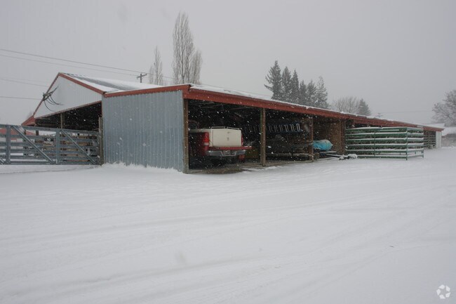
Property Record
25007 E Wellesley Ave, Otis Orchards, WA 99027

NEARBY LISTINGS FOR SALE OR LEASE
Property Detail
25007 E Wellesley Ave
56354.9278
SE1/4 35-26-45 PTN SE1/4 OF SE1/4 OF SE1/4 LYG S OF SPOKANE INT RR ROW EXC STRIP 50 WIDE LYG S & ADJ SPO INT RR ROW & EXC BEG AT PT 30 N & 30 W OF SE COR TH N 352 TH S89DEG44MIN05SECW 51 TH S 135 TH S89DEG44MIN05SECW 10 TH S 19 TH S89DEG44MIN05SECW 6
Commercialnec
Spokane
X
Washington
53063C0605D
3.45 AC
2025
Valley
2025
Spokane
013201
Spokane-Spokane Valley, WA
14,102 SF
DEMOGRAPHICS near 25007 E Wellesley Ave
1 Mile
3 Mile
5 Mile
2024 Total Population
2,584
18,449
43,653
2029 Population
2,721
19,888
47,930
Pop Growth 2024-2029
+ 5.30%
+ 7.80%
+ 9.80%
Average Age
42
41
41
2024 Total Households
898
6,869
16,820
HH Growth 2024-2029
+ 5.46%
+ 7.96%
+ 9.80%
Median Household Inc
$93,074
$92,674
$81,457
Avg Household Size
2.80
2.60
2.60
2024 Avg HH Vehicles
3.00
2.00
2.00
Median Home Value
$414,052
$440,045
$443,126
Median Year Built
1977
1993
1996
Nearby Places
Map Layers
Map Styles
 Street
 Aerial
- Restaurants
- Banks
- Shops
- Fitness
- Groceries
PUBLIC TRANSPORTATION
AIRPORT
Spokane International
DRIVE
WALK
Distance
Spokane International
36 min
26.4 mi
Nearby Properties
Address
Land Use
TOTAL SIZE
Lot Size
Zoning
Address
Land Use
TOTAL SIZE
Lot Size
Zoning
602,024 SF
44.20 AC
I
Address
Land Use
TOTAL SIZE
Lot Size
Zoning
358,700 SF
16.41 AC
R3
Address
Land Use
TOTAL SIZE
Lot Size
Zoning
182,288 SF
45.50 AC
MZ
Address
Land Use
TOTAL SIZE
Lot Size
Zoning
153,691 SF
24.92 AC
P
Address
Land Use
TOTAL SIZE
Lot Size
Zoning
150,900 SF
7.24 AC
AG
Address
Land Use
TOTAL SIZE
Lot Size
Zoning
235,906 SF
13.17 AC
Address
Land Use
TOTAL SIZE
Lot Size
Zoning
25,698 SF
11.33 AC
Address
Land Use
TOTAL SIZE
Lot Size
Zoning
145,377 SF
35.35 AC
Address
Land Use
TOTAL SIZE
Lot Size
Zoning
26,619 SF
15 AC
Address
Land Use
TOTAL SIZE
Lot Size
Zoning
165,984 SF
9.61 AC
Address
Land Use
TOTAL SIZE
Lot Size
Zoning
129,238 SF
24.58 AC
AG
Address
Land Use
TOTAL SIZE
Lot Size
Zoning
78,795 SF
39.53 AC
C2
Address
Land Use
TOTAL SIZE
Lot Size
Zoning
156,211 SF
17.09 AC
Address
Land Use
TOTAL SIZE
Lot Size
Zoning
3,918 SF
135.08 AC
O
Address
Land Use
TOTAL SIZE
Lot Size
Zoning
82,600 SF
9.27 AC
I
Address
Land Use
TOTAL SIZE
Lot Size
Zoning
199,920 SF
18.36 AC
COMDEV
Address
Land Use
TOTAL SIZE
Lot Size
Zoning
104,962 SF
4.86 AC
Address
Land Use
TOTAL SIZE
Lot Size
Zoning
64,280 SF
5.80 AC
I
Address
Land Use
TOTAL SIZE
Lot Size
Zoning
154,265 SF
13.38 AC
I
Address
Land Use
TOTAL SIZE
Lot Size
Zoning
64,648 SF
14.82 AC
AG
Address
Land Use
TOTAL SIZE
Lot Size
Zoning
184,710 SF
13.12 AC
I
Address
Land Use
TOTAL SIZE
Lot Size
Zoning
202,570 SF
21.72 AC
I
Address
Land Use
TOTAL SIZE
Lot Size
Zoning
296,341 SF
23.08 AC
I
Address
Land Use
TOTAL SIZE
Lot Size
Zoning
140,395 SF
10.44 AC
I
Address
Land Use
TOTAL SIZE
Lot Size
Zoning
103,056 SF
8.18 AC
Address
Land Use
TOTAL SIZE
Lot Size
Zoning
64,280 SF
7.98 AC
I
Address
Land Use
TOTAL SIZE
Lot Size
Zoning
33,288 SF
5.53 AC
Address
Land Use
TOTAL SIZE
Lot Size
Zoning
115,992 SF
6.87 AC
Address
Land Use
TOTAL SIZE
Lot Size
Zoning
75,021 SF
3.02 AC
SAP
The World's #1 Commercial Real Estate Marketplace
Connect with us
© 2025 CoStar Group
The information above has been obtained from sources believed reliable. While we do not doubt its accuracy we have not verified it and make no guarantee, warranty or representation about it. It is your responsibility to independently confirm its accuracy and completeness. Any projections, opinions, assumptions, or estimates used are for example only and do not represent the current or future performance of the property. The value of this transaction to you depends on tax and other factors which should be evaluated by your tax, financial, and legal advisors. You and your advisors should conduct a careful, independent investigation of the property to determine to your satisfaction the suitability of the property for your needs.