Property Record
2501 80Th St Sw, Cedar Rapids, IA 52404
Current Lease Availabilities
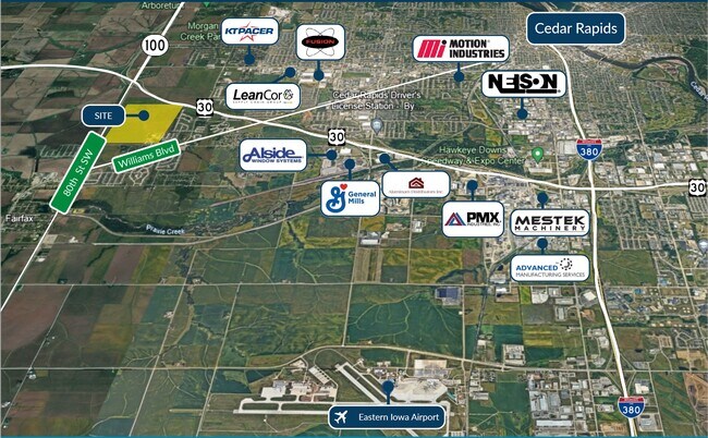
NEARBY LISTINGS FOR SALE OR LEASE
-
-
View all Cedar Rapids listings for lease on LoopNet.com
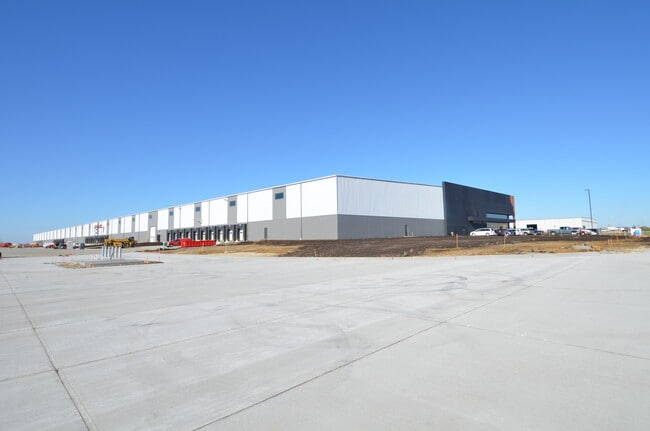
Property Detail
2501 80Th St Sw
Cedar Rapids, IA
Holets & Mc Collisters
13343-51001-00000
SW SW-EX HOLETS & MC COLLISTERS & EX RD
Agriculturalland
Linn
X
Iowa
19113C0385E
36.57 AC
2024
Iowa City/Waterloo
2025
Other Market Areas
002900
DEMOGRAPHICS near 2501 80Th St Sw
1 Mile
3 Mile
5 Mile
2024 Total Population
1,034
25,268
52,160
2029 Population
1,076
25,733
52,655
Pop Growth 2024-2029
+ 4.06%
+ 1.84%
+ 0.95%
Average Age
44
41
41
2024 Total Households
448
10,625
21,650
HH Growth 2024-2029
+ 3.79%
+ 1.95%
+ 0.99%
Median Household Inc
$86,989
$69,968
$66,443
Avg Household Size
2.30
2.30
2.30
2024 Avg HH Vehicles
2.00
2.00
2.00
Median Home Value
$271,590
$212,621
$193,959
Median Year Built
2001
1992
1979
Nearby Places
- Restaurants
- Banks
- Shops
- Fitness
- Groceries
PUBLIC TRANSPORTATION
AIRPORT
The Eastern Iowa
DRIVE
WALK
Distance
The Eastern Iowa
17 min
8.3 mi
Nearby Properties
Address
Land Use
TOTAL SIZE
Lot Size
Zoning
Address
Land Use
TOTAL SIZE
Lot Size
Zoning
427,700 SF
12.67 AC
Address
Land Use
TOTAL SIZE
Lot Size
Zoning
68,553 SF
7.70 AC
Address
Land Use
TOTAL SIZE
Lot Size
Zoning
42,449 SF
4.70 AC
Address
Land Use
TOTAL SIZE
Lot Size
Zoning
541,028 SF
76.36 AC
AG
Address
Land Use
TOTAL SIZE
Lot Size
Zoning
1,049,268 SF
79.35 AC
Address
Land Use
TOTAL SIZE
Lot Size
Zoning
59,467 SF
8.39 AC
Address
Land Use
TOTAL SIZE
Lot Size
Zoning
66,922 SF
4.90 AC
Address
Land Use
TOTAL SIZE
Lot Size
Zoning
416,830 SF
18.06 AC
Address
Land Use
TOTAL SIZE
Lot Size
Zoning
88,849 SF
18.63 AC
Address
Land Use
TOTAL SIZE
Lot Size
Zoning
212,316 SF
23.89 AC
Address
Land Use
TOTAL SIZE
Lot Size
Zoning
189,188 SF
19.44 AC
Address
Land Use
TOTAL SIZE
Lot Size
Zoning
175,600 SF
15.91 AC
Address
Land Use
TOTAL SIZE
Lot Size
Zoning
44,754 SF
6 AC
Address
Land Use
TOTAL SIZE
Lot Size
Zoning
68,384 SF
17.90 AC
Address
Land Use
TOTAL SIZE
Lot Size
Zoning
70,918 SF
6.70 AC
Address
Land Use
TOTAL SIZE
Lot Size
Zoning
49,896 SF
3.80 AC
Address
Land Use
TOTAL SIZE
Lot Size
Zoning
274,433 SF
17.68 AC
Address
Land Use
TOTAL SIZE
Lot Size
Zoning
14,839 SF
1.82 AC
Address
Land Use
TOTAL SIZE
Lot Size
Zoning
232,750 SF
9.65 AC
Address
Land Use
TOTAL SIZE
Lot Size
Zoning
39,679 SF
28.85 AC
Address
Land Use
TOTAL SIZE
Lot Size
Zoning
15,196 SF
1.79 AC
Address
Land Use
TOTAL SIZE
Lot Size
Zoning
46,128 SF
20.84 AC
Address
Land Use
TOTAL SIZE
Lot Size
Zoning
47,460 SF
8.22 AC
Address
Land Use
TOTAL SIZE
Lot Size
Zoning
29,992 SF
6.25 AC
Address
Land Use
TOTAL SIZE
Lot Size
Zoning
20,367 SF
2.68 AC
Address
Land Use
TOTAL SIZE
Lot Size
Zoning
68,432 SF
2.08 AC
Address
Land Use
TOTAL SIZE
Lot Size
Zoning
18,249 SF
3.23 AC
Address
Land Use
TOTAL SIZE
Lot Size
Zoning
150,614 SF
160 AC
AG
Address
Land Use
TOTAL SIZE
Lot Size
Zoning
88,641 SF
4.83 AC
Address
Land Use
TOTAL SIZE
Lot Size
Zoning
65,248 SF
4.26 AC
The World's #1 Commercial Real Estate Marketplace
Connect with us
© 2025 CoStar Group
The information above has been obtained from sources believed reliable. While we do not doubt its accuracy we have not verified it and make no guarantee, warranty or representation about it. It is your responsibility to independently confirm its accuracy and completeness. Any projections, opinions, assumptions, or estimates used are for example only and do not represent the current or future performance of the property. The value of this transaction to you depends on tax and other factors which should be evaluated by your tax, financial, and legal advisors. You and your advisors should conduct a careful, independent investigation of the property to determine to your satisfaction the suitability of the property for your needs.