Property Record
2501 Ames Ave, Omaha, NE 68111

Property Detail
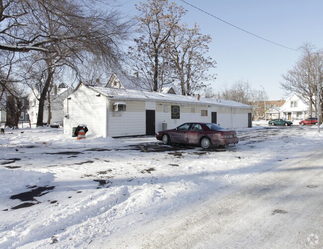
2501 Ames Ave
2006-0000-14
ISABEL ADD LOT 1 BLOCK 2 45 X 125.5
Bartavern
Douglas
GC
Nebraska
B and X Area of moderate flood hazard, usually the area between the limits of the 100-year and 500-year floods.
1
2025
0.13 AC
2025
Northeast Omaha
000700
Omaha/Council Bluffs
1,600 SF
Omaha, NE-IA
NEARBY LISTINGS FOR SALE OR LEASE
DEMOGRAPHICS near 2501 Ames Ave
1 mile
3 mile
5 mile
2025 Total Population
13,130
95,914
222,555
2030 Population
13,718
99,215
229,133
Pop Growth 2025-2030
+ 4.48%
+ 3.44%
+ 2.96%
Average Age
36
36
37
2025 Total Households
4,677
36,461
90,155
HH Growth 2025-2030
+ 4.68%
+ 3.79%
+ 3.29%
Median Household Inc
$39,381
$50,612
$57,444
Avg Household Size
2.70
2.40
2.30
2025 Avg HH Vehicles
1.00
2.00
2.00
Median Home Value
$116,258
$159,616
$186,973
Median Year Built
1948
1954
1955
Nearby Places
Map Layers
Map Styles
 Street
 Aerial
Layers
 Traffic
 Biking
Places
Listings with unknown addresses are not visible on the map
- Restaurants
- Banks
- Shops
- Fitness
- Groceries
PUBLIC TRANSPORTATION
AIRPORT
Eppley Airfield
Drive
Walk
Distance
Eppley Airfield
11 min
4.3 mi
Nearby Properties
Address
Land Use
TOTAL SIZE
Lot Size
Zoning
Address
Land Use
TOTAL SIZE
Lot Size
Zoning
1,068,760 SF
1.72 AC
Address
Land Use
TOTAL SIZE
Lot Size
Zoning
1,318,852 SF
8.77 AC
Address
Land Use
TOTAL SIZE
Lot Size
Zoning
603,518 SF
5.55 AC
CBD
Address
Land Use
TOTAL SIZE
Lot Size
Zoning
362,402 SF
1.94 AC
Address
Land Use
TOTAL SIZE
Lot Size
Zoning
318,811 SF
11.51 AC
Address
Land Use
TOTAL SIZE
Lot Size
Zoning
254,306 SF
0.82 AC
Address
Land Use
TOTAL SIZE
Lot Size
Zoning
1,027,620 SF
4.33 AC
Address
Land Use
TOTAL SIZE
Lot Size
Zoning
378,420 SF
0.72 AC
Address
Land Use
TOTAL SIZE
Lot Size
Zoning
276,622 SF
3.90 AC
Address
Land Use
TOTAL SIZE
Lot Size
Zoning
189,720 SF
1.22 AC
CBD
Address
Land Use
TOTAL SIZE
Lot Size
Zoning
335,431 SF
0.79 AC
Address
Land Use
TOTAL SIZE
Lot Size
Zoning
274,024 SF
1.46 AC
Address
Land Use
TOTAL SIZE
Lot Size
Zoning
254,548 SF
1.67 AC
Address
Land Use
TOTAL SIZE
Lot Size
Zoning
200,501 SF
1.78 AC
DS
Address
Land Use
TOTAL SIZE
Lot Size
Zoning
281,014 SF
3.68 AC
Address
Land Use
TOTAL SIZE
Lot Size
Zoning
200,580 SF
3.22 AC
Address
Land Use
TOTAL SIZE
Lot Size
Zoning
148,805 SF
0.92 AC
Address
Land Use
TOTAL SIZE
Lot Size
Zoning
73,337 SF
0.85 AC
Address
Land Use
TOTAL SIZE
Lot Size
Zoning
96,400 SF
1.85 AC
Address
Land Use
TOTAL SIZE
Lot Size
Zoning
115,920 SF
0.33 AC
Address
Land Use
TOTAL SIZE
Lot Size
Zoning
39.68 AC
Address
Land Use
TOTAL SIZE
Lot Size
Zoning
126,687 SF
1.71 AC
Address
Land Use
TOTAL SIZE
Lot Size
Zoning
266,775 SF
18.22 AC
CBD
Address
Land Use
TOTAL SIZE
Lot Size
Zoning
80,060 SF
Address
Land Use
TOTAL SIZE
Lot Size
Zoning
18.12 AC
Address
Land Use
TOTAL SIZE
Lot Size
Zoning
158,816 SF
0.40 AC
Address
Land Use
TOTAL SIZE
Lot Size
Zoning
123,110 SF
0.80 AC
Address
Land Use
TOTAL SIZE
Lot Size
Zoning
130,783 SF
0.39 AC
Address
Land Use
TOTAL SIZE
Lot Size
Zoning
237,085 SF
4.26 AC
The World's #1 Commercial Real Estate Marketplace
Connect with us
© 2026 CoStar Group
The information above has been obtained from sources believed reliable. While we do not doubt its accuracy we have not verified it and make no guarantee, warranty or representation about it. It is your responsibility to independently confirm its accuracy and completeness. Any projections, opinions, assumptions, or estimates used are for example only and do not represent the current or future performance of the property. The value of this transaction to you depends on tax and other factors which should be evaluated by your tax, financial, and legal advisors. You and your advisors should conduct a careful, independent investigation of the property to determine to your satisfaction the suitability of the property for your needs.