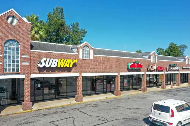
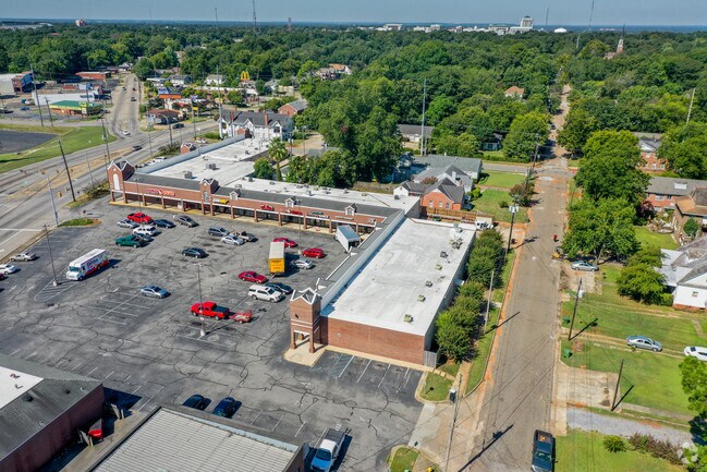
Property Record
2501 Atlanta Hwy, Montgomery, AL 36107
NEARBY LISTINGS FOR SALE OR LEASE
-
-
-
-
No Photo
-
-
-
-
View all Montgomery listings for sale on LoopNet.com
Property Detail
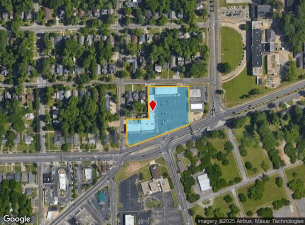
2501 Atlanta Hwy
Montgomery, AL
Madison Square
10-02-09-2-013-002.000
1002092013002000
Stripcommercialcenter
Montgomery
X
Alabama
01051C0445F
1
2025
2.40 AC
2025
North Montgomery
000500
Montgomery
29,378 SF
DEMOGRAPHICS near 2501 Atlanta Hwy
1 Mile
3 Mile
5 Mile
2024 Total Population
10,849
61,095
136,018
2029 Population
10,694
60,271
133,994
Pop Growth 2024-2029
(1.43%)
(1.35%)
(1.49%)
Average Age
37
38
38
2024 Total Households
4,556
24,937
56,456
HH Growth 2024-2029
(1.51%)
(1.26%)
(1.47%)
Median Household Inc
$36,182
$44,497
$40,363
Avg Household Size
2.30
2.20
2.20
2024 Avg HH Vehicles
2.00
2.00
2.00
Median Home Value
$98,194
$137,500
$120,696
Median Year Built
1952
1964
1972
Nearby Places
Map Layers
Map Styles
 Street
 Aerial
- Restaurants
- Banks
- Shops
- Fitness
- Groceries
PUBLIC TRANSPORTATION
AIRPORT
Montgomery Regional (Dannelly Field)
DRIVE
WALK
Distance
Montgomery Regional (Dannelly Field)
17 min
11.3 mi
Freight Ports
Port of Panama City
DRIVE
WALK
Distance
Port of Panama City
240 min
188.3 mi
Nearby Properties
Address
Land Use
TOTAL SIZE
Lot Size
Zoning
Address
Land Use
TOTAL SIZE
Lot Size
Zoning
800,140 SF
2.27 AC
T5
Address
Land Use
TOTAL SIZE
Lot Size
Zoning
392,741 SF
2.98 AC
T5
Address
Land Use
TOTAL SIZE
Lot Size
Zoning
150,842 SF
5.40 AC
T5
Address
Land Use
TOTAL SIZE
Lot Size
Zoning
193,643 SF
1.61 AC
T5
Address
Land Use
TOTAL SIZE
Lot Size
Zoning
427,546 SF
37.68 AC
M-1
Address
Land Use
TOTAL SIZE
Lot Size
Zoning
36,543 SF
0.62 AC
SD-M
Address
Land Use
TOTAL SIZE
Lot Size
Zoning
40,829 SF
50.49 AC
SD
Address
Land Use
TOTAL SIZE
Lot Size
Zoning
10,844 SF
1.63 AC
Address
Land Use
TOTAL SIZE
Lot Size
Zoning
285,162 SF
M-1
Address
Land Use
TOTAL SIZE
Lot Size
Zoning
107,355 SF
4.12 AC
T5
Address
Land Use
TOTAL SIZE
Lot Size
Zoning
216,654 SF
26.49 AC
B-2
Address
Land Use
TOTAL SIZE
Lot Size
Zoning
93,981 SF
1.90 AC
T5
Address
Land Use
TOTAL SIZE
Lot Size
Zoning
13,273 SF
2.05 AC
T5
Address
Land Use
TOTAL SIZE
Lot Size
Zoning
8,519 SF
15.60 AC
B-2
Address
Land Use
TOTAL SIZE
Lot Size
Zoning
58,930 SF
2.24 AC
T5
Address
Land Use
TOTAL SIZE
Lot Size
Zoning
122,119 SF
21 AC
R-75-S
Address
Land Use
TOTAL SIZE
Lot Size
Zoning
91,378 SF
2.46 AC
SD-M
Address
Land Use
TOTAL SIZE
Lot Size
Zoning
117,175 SF
1.49 AC
T5
Address
Land Use
TOTAL SIZE
Lot Size
Zoning
113,449 SF
0.80 AC
T5
Address
Land Use
TOTAL SIZE
Lot Size
Zoning
77,905 SF
0.83 AC
T5
Address
Land Use
TOTAL SIZE
Lot Size
Zoning
38,226 SF
5.77 AC
T5
Address
Land Use
TOTAL SIZE
Lot Size
Zoning
120,509 SF
0.29 AC
T5
Address
Land Use
TOTAL SIZE
Lot Size
Zoning
1.72 AC
T5
Address
Land Use
TOTAL SIZE
Lot Size
Zoning
84,764 SF
5.20 AC
B-2
Address
Land Use
TOTAL SIZE
Lot Size
Zoning
105,816 SF
4.34 AC
B-2
Address
Land Use
TOTAL SIZE
Lot Size
Zoning
22,183 SF
8.38 AC
T5
Address
Land Use
TOTAL SIZE
Lot Size
Zoning
249,231 SF
20 AC
INST
Address
Land Use
TOTAL SIZE
Lot Size
Zoning
116,707 SF
0.28 AC
T5
Address
Land Use
TOTAL SIZE
Lot Size
Zoning
96,168 SF
95.16 AC
INST
Address
Land Use
TOTAL SIZE
Lot Size
Zoning
1,721 SF
12.02 AC
R-60-M
The World's #1 Commercial Real Estate Marketplace
Connect with us
© 2025 CoStar Group
The information above has been obtained from sources believed reliable. While we do not doubt its accuracy we have not verified it and make no guarantee, warranty or representation about it. It is your responsibility to independently confirm its accuracy and completeness. Any projections, opinions, assumptions, or estimates used are for example only and do not represent the current or future performance of the property. The value of this transaction to you depends on tax and other factors which should be evaluated by your tax, financial, and legal advisors. You and your advisors should conduct a careful, independent investigation of the property to determine to your satisfaction the suitability of the property for your needs.