Property Record
2501 Avalanche Rd, Sturgis, SD 57785
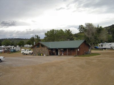

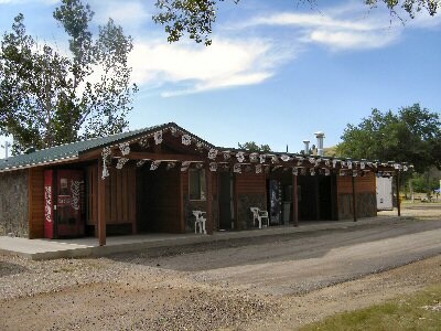
Property Detail
2501 Avalanche Rd
Rapid City, SD
5-5-5
01.70.06.01
Meade
Commercialnec
South Dakota
AE The base floodplain where base flood elevations are provided. AE Zones are now used on new format FIRMs instead of A1-A30 Zones.
8.87 AC
2024
South Dakota Area
2025
Other Market Areas
020402
NEARBY LISTINGS FOR SALE OR LEASE
-
-
View all Sturgis listings for sale on LoopNet.com
DEMOGRAPHICS near 2501 Avalanche Rd
1 mile
3 mile
5 mile
2025 Total Population
313
7,116
9,432
2030 Population
323
7,325
9,836
Pop Growth 2025-2030
+ 3.19%
+ 2.94%
+ 4.28%
Average Age
40
43
43
2025 Total Households
138
3,104
4,131
HH Growth 2025-2030
+ 3.62%
+ 2.93%
+ 4.41%
Median Household Inc
$45,395
$55,373
$57,873
Avg Household Size
2.20
2.20
2.20
2025 Avg HH Vehicles
1.00
2.00
2.00
Median Home Value
$107,143
$278,476
$298,528
Median Year Built
1981
1976
1976
Nearby Places
Map Layers
Map Styles
 Street
 Aerial
Transit
 Traffic
 Biking
Places
Listings with unknown addresses are not visible on the map
- Restaurants
- Banks
- Shops
- Fitness
- Groceries
Nearby Properties
Address
Land Use
TOTAL SIZE
Lot Size
Zoning
Address
Land Use
TOTAL SIZE
Lot Size
Zoning
4.05 AC
Address
Land Use
TOTAL SIZE
Lot Size
Zoning
1.45 AC
Address
Land Use
TOTAL SIZE
Lot Size
Zoning
0.43 AC
Address
Land Use
TOTAL SIZE
Lot Size
Zoning
8.28 AC
Address
Land Use
TOTAL SIZE
Lot Size
Zoning
1.10 AC
Address
Land Use
TOTAL SIZE
Lot Size
Zoning
9.31 AC
Address
Land Use
TOTAL SIZE
Lot Size
Zoning
4.06 AC
Address
Land Use
TOTAL SIZE
Lot Size
Zoning
672 SF
250.54 AC
Address
Land Use
TOTAL SIZE
Lot Size
Zoning
3.42 AC
Address
Land Use
TOTAL SIZE
Lot Size
Zoning
3.30 AC
Address
Land Use
TOTAL SIZE
Lot Size
Zoning
1.79 AC
Address
Land Use
TOTAL SIZE
Lot Size
Zoning
1.96 AC
Address
Land Use
TOTAL SIZE
Lot Size
Zoning
1.03 AC
Address
Land Use
TOTAL SIZE
Lot Size
Zoning
Address
Land Use
TOTAL SIZE
Lot Size
Zoning
3.05 AC
Address
Land Use
TOTAL SIZE
Lot Size
Zoning
1.61 AC
Address
Land Use
TOTAL SIZE
Lot Size
Zoning
0.16 AC
Address
Land Use
TOTAL SIZE
Lot Size
Zoning
19.72 AC
Address
Land Use
TOTAL SIZE
Lot Size
Zoning
0.34 AC
Address
Land Use
TOTAL SIZE
Lot Size
Zoning
0.43 AC
Address
Land Use
TOTAL SIZE
Lot Size
Zoning
2.83 AC
Address
Land Use
TOTAL SIZE
Lot Size
Zoning
1.88 AC
Address
Land Use
TOTAL SIZE
Lot Size
Zoning
1.09 AC
Address
Land Use
TOTAL SIZE
Lot Size
Zoning
Address
Land Use
TOTAL SIZE
Lot Size
Zoning
Address
Land Use
TOTAL SIZE
Lot Size
Zoning
3.13 AC
Address
Land Use
TOTAL SIZE
Lot Size
Zoning
0.95 AC
Address
Land Use
TOTAL SIZE
Lot Size
Zoning
1.12 AC
Address
Land Use
TOTAL SIZE
Lot Size
Zoning
Address
Land Use
TOTAL SIZE
Lot Size
Zoning
1.16 AC
The World's #1 Commercial Real Estate Marketplace
Connect with us
© 2026 CoStar Group
The information above has been obtained from sources believed reliable. While we do not doubt its accuracy we have not verified it and make no guarantee, warranty or representation about it. It is your responsibility to independently confirm its accuracy and completeness. Any projections, opinions, assumptions, or estimates used are for example only and do not represent the current or future performance of the property. The value of this transaction to you depends on tax and other factors which should be evaluated by your tax, financial, and legal advisors. You and your advisors should conduct a careful, independent investigation of the property to determine to your satisfaction the suitability of the property for your needs.