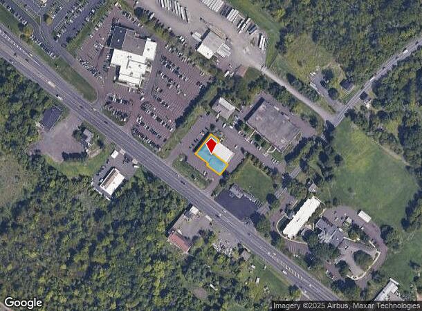
Property Record
2501 Bethlehem Pike, Hatfield, PA 19440
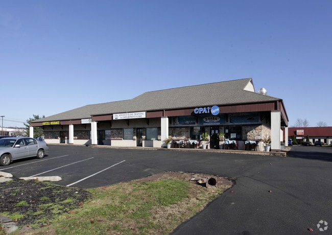
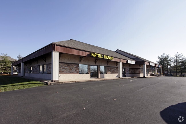

This Property Is For Sale
Current Lease Availabilities
NEARBY LISTINGS FOR SALE OR LEASE
Property Detail
2501 Bethlehem Pike
15-022-065-00A
Garden Spot Ii Condo
Commercialcondominium
UNIT A GARDEN SPOT II CONDO 8,000SF
X
Bucks
42091C0141G
Pennsylvania
2024
0.23 AC
2025
Upper Bucks County
102104
Philadelphia
12,668 SF
Philadelphia-Camden-Wilmington, PA-NJ-DE-MD
DEMOGRAPHICS near 2501 Bethlehem Pike
1 Mile
3 Mile
5 Mile
2024 Total Population
2,781
44,395
136,166
2029 Population
2,823
45,154
137,439
Pop Growth 2024-2029
+ 1.51%
+ 1.71%
+ 0.93%
Average Age
38
42
42
2024 Total Households
1,244
17,014
52,146
HH Growth 2024-2029
+ 1.37%
+ 1.63%
+ 0.86%
Median Household Inc
$49,760
$90,955
$98,442
Avg Household Size
2.20
2.50
2.50
2024 Avg HH Vehicles
1.00
2.00
2.00
Median Home Value
$481,666
$342,624
$360,155
Median Year Built
1972
1976
1977
Nearby Places
Map Layers
Map Styles
 Street
 Aerial
- Restaurants
- Banks
- Shops
- Fitness
- Groceries
PUBLIC TRANSPORTATION
COMMUTER RAIL
Link Belt (R5 - Southeastern Pennsylvania Transportation Authority Regional Rail (SEPTA Regional Rail))
DRIVE
WALK
Distance
Link Belt (R5 - Southeastern Pennsylvania Transportation Authority Regional Rail (SEPTA Regional Rail))
5 min
3.0 mi
Colmar (R5 - Southeastern Pennsylvania Transportation Authority Regional Rail (SEPTA Regional Rail))
DRIVE
WALK
Distance
Colmar (R5 - Southeastern Pennsylvania Transportation Authority Regional Rail (SEPTA Regional Rail))
6 min
3.0 mi
AIRPORT
Lehigh Valley International
DRIVE
WALK
Distance
Lehigh Valley International
49 min
30.2 mi
Trenton Mercer
DRIVE
WALK
Distance
Trenton Mercer
57 min
33.3 mi
Philadelphia International
DRIVE
WALK
Distance
Philadelphia International
60 min
42.0 mi
Freight Ports
Port of Philadelphia
DRIVE
WALK
Distance
Port of Philadelphia
45 min
27.2 mi
Nearby Properties
Address
Land Use
TOTAL SIZE
Lot Size
Zoning
Address
Land Use
TOTAL SIZE
Lot Size
Zoning
977,439 SF
70.93 AC
GA
Address
Land Use
TOTAL SIZE
Lot Size
Zoning
832,830 SF
53.72 AC
LI
Address
Land Use
TOTAL SIZE
Lot Size
Zoning
253,915 SF
17.78 AC
GA
Address
Land Use
TOTAL SIZE
Lot Size
Zoning
219,869 SF
41.98 AC
LI
Address
Land Use
TOTAL SIZE
Lot Size
Zoning
373,104 SF
31.94 AC
LI
Address
Land Use
TOTAL SIZE
Lot Size
Zoning
131,631 SF
18.12 AC
SC
Address
Land Use
TOTAL SIZE
Lot Size
Zoning
220,124 SF
33.16 AC
SC
Address
Land Use
TOTAL SIZE
Lot Size
Zoning
152,085 SF
38.16 AC
INST
Address
Land Use
TOTAL SIZE
Lot Size
Zoning
168,557 SF
44.77 AC
RA1
Address
Land Use
TOTAL SIZE
Lot Size
Zoning
444,718 SF
46.51 AC
LI
Address
Land Use
TOTAL SIZE
Lot Size
Zoning
324,796 SF
42.20 AC
LI
Address
Land Use
TOTAL SIZE
Lot Size
Zoning
216,372 SF
18.46 AC
INST
Address
Land Use
TOTAL SIZE
Lot Size
Zoning
502,169 SF
83.16 AC
LI
Address
Land Use
TOTAL SIZE
Lot Size
Zoning
35.37 AC
LI
Address
Land Use
TOTAL SIZE
Lot Size
Zoning
213,542 SF
26.53 AC
LI
Address
Land Use
TOTAL SIZE
Lot Size
Zoning
184,471 SF
0.80 AC
INST
Address
Land Use
TOTAL SIZE
Lot Size
Zoning
65,178 SF
16.86 AC
B
Address
Land Use
TOTAL SIZE
Lot Size
Zoning
198,551 SF
21.17 AC
LI
Address
Land Use
TOTAL SIZE
Lot Size
Zoning
94,598 SF
27.72 AC
INST
Address
Land Use
TOTAL SIZE
Lot Size
Zoning
301,131 SF
18.98 AC
LI
Address
Land Use
TOTAL SIZE
Lot Size
Zoning
230,016 SF
11.27 AC
LI
Address
Land Use
TOTAL SIZE
Lot Size
Zoning
182,010 SF
12.25 AC
LI
Address
Land Use
TOTAL SIZE
Lot Size
Zoning
40,754 SF
6.23 AC
LI
Address
Land Use
TOTAL SIZE
Lot Size
Zoning
71,153 SF
20.48 AC
A1
Address
Land Use
TOTAL SIZE
Lot Size
Zoning
60,470 SF
14.60 AC
ER
Address
Land Use
TOTAL SIZE
Lot Size
Zoning
85,508 SF
25.83 AC
Address
Land Use
TOTAL SIZE
Lot Size
Zoning
237,667 SF
37.86 AC
LI
Address
Land Use
TOTAL SIZE
Lot Size
Zoning
121,762 SF
16.66 AC
LI
Address
Land Use
TOTAL SIZE
Lot Size
Zoning
63,183 SF
23.05 AC
INST
Address
Land Use
TOTAL SIZE
Lot Size
Zoning
79,335 SF
11.50 AC
LI
The World's #1 Commercial Real Estate Marketplace
Connect with us
© 2025 CoStar Group
The information above has been obtained from sources believed reliable. While we do not doubt its accuracy we have not verified it and make no guarantee, warranty or representation about it. It is your responsibility to independently confirm its accuracy and completeness. Any projections, opinions, assumptions, or estimates used are for example only and do not represent the current or future performance of the property. The value of this transaction to you depends on tax and other factors which should be evaluated by your tax, financial, and legal advisors. You and your advisors should conduct a careful, independent investigation of the property to determine to your satisfaction the suitability of the property for your needs.