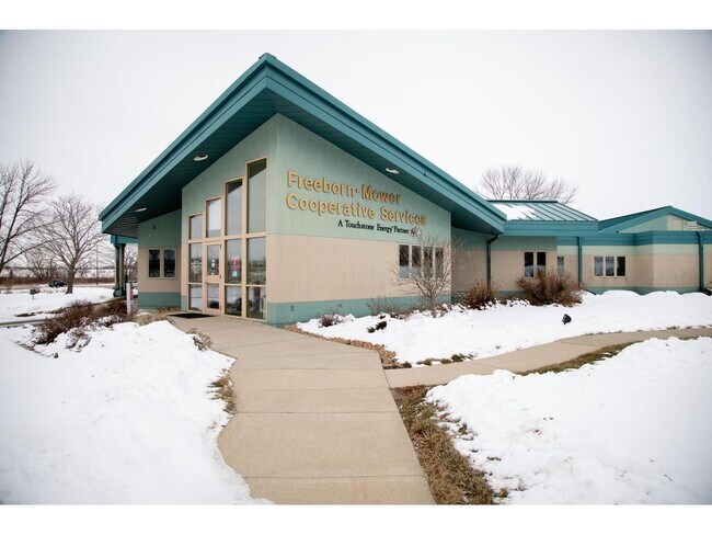
Property Record
2501 E Main St, Albert Lea, MN 56007


Property Detail
2501 E Main St
34.350.0010
SECT-02 TWP-102 RANGE-021 11.71 AC REV DESC NO. 2919 PT S1/2 SW1/4 2-102-21 11.71 ACRES CITY OF ALBERT LEA
Commercialnec
Freeborn
B2
Minnesota
B and X Area of moderate flood hazard, usually the area between the limits of the 100-year and 500-year floods.
11.71 AC
2025
Minnesota South Area
2025
Other Market Areas
180600
Albert Lea, MN
NEARBY LISTINGS FOR SALE OR LEASE
-
-
View all Albert Lea listings for sale on LoopNet.com
DEMOGRAPHICS near 2501 E Main St
1 mile
3 mile
5 mile
2025 Total Population
231
12,272
19,971
2030 Population
227
12,140
19,782
Pop Growth 2025-2030
(1.73%)
(1.08%)
(0.95%)
Average Age
43
42
43
2025 Total Households
100
5,202
8,521
HH Growth 2025-2030
(2.00%)
(1.11%)
(0.95%)
Median Household Inc
$74,249
$61,513
$63,278
Avg Household Size
2.30
2.30
2.20
2025 Avg HH Vehicles
2.00
2.00
2.00
Median Home Value
$140,000
$151,414
$162,333
Median Year Built
1958
1954
1959
Nearby Places
Map Layers
Map Styles
 Street
 Aerial
Layers
 Traffic
 Biking
Places
Listings with unknown addresses are not visible on the map
- Restaurants
- Banks
- Shops
- Fitness
- Groceries
SALE & LEASE HISTORY
LISTING DATE
SALE/LEASE

Feb 19, 2021
For Sale
Nearby Properties
Address
Land Use
TOTAL SIZE
Lot Size
Zoning
Address
Land Use
TOTAL SIZE
Lot Size
Zoning
8.30 AC
PD
Address
Land Use
TOTAL SIZE
Lot Size
Zoning
2.01 AC
B3
Address
Land Use
TOTAL SIZE
Lot Size
Zoning
21.14 AC
Address
Land Use
TOTAL SIZE
Lot Size
Zoning
81.57 AC
I1
Address
Land Use
TOTAL SIZE
Lot Size
Zoning
5.41 AC
PD
Address
Land Use
TOTAL SIZE
Lot Size
Zoning
15.50 AC
Address
Land Use
TOTAL SIZE
Lot Size
Zoning
16.79 AC
B2
Address
Land Use
TOTAL SIZE
Lot Size
Zoning
Address
Land Use
TOTAL SIZE
Lot Size
Zoning
69,582 SF
12.88 AC
B2
Address
Land Use
TOTAL SIZE
Lot Size
Zoning
31.20 AC
IDD
Address
Land Use
TOTAL SIZE
Lot Size
Zoning
247,732 SF
13.04 AC
I2
Address
Land Use
TOTAL SIZE
Lot Size
Zoning
4.98 AC
Address
Land Use
TOTAL SIZE
Lot Size
Zoning
4.87 AC
I2
Address
Land Use
TOTAL SIZE
Lot Size
Zoning
9.37 AC
I2
Address
Land Use
TOTAL SIZE
Lot Size
Zoning
12.80 AC
PD
Address
Land Use
TOTAL SIZE
Lot Size
Zoning
0.26 AC
B3
Address
Land Use
TOTAL SIZE
Lot Size
Zoning
2.90 AC
R3
Address
Land Use
TOTAL SIZE
Lot Size
Zoning
0.29 AC
Address
Land Use
TOTAL SIZE
Lot Size
Zoning
14.73 AC
B4
Address
Land Use
TOTAL SIZE
Lot Size
Zoning
70,530 SF
5.68 AC
I2
Address
Land Use
TOTAL SIZE
Lot Size
Zoning
44,604 SF
3.85 AC
Address
Land Use
TOTAL SIZE
Lot Size
Zoning
2.12 AC
Address
Land Use
TOTAL SIZE
Lot Size
Zoning
58.53 AC
R3
Address
Land Use
TOTAL SIZE
Lot Size
Zoning
3.63 AC
Address
Land Use
TOTAL SIZE
Lot Size
Zoning
60,296 SF
4.14 AC
B2
Address
Land Use
TOTAL SIZE
Lot Size
Zoning
1.84 AC
B2
Address
Land Use
TOTAL SIZE
Lot Size
Zoning
0.73 AC
I1
Address
Land Use
TOTAL SIZE
Lot Size
Zoning
45.28 AC
PD
Address
Land Use
TOTAL SIZE
Lot Size
Zoning
6.92 AC
B2
The World's #1 Commercial Real Estate Marketplace
Connect with us
© 2026 CoStar Group
The information above has been obtained from sources believed reliable. While we do not doubt its accuracy we have not verified it and make no guarantee, warranty or representation about it. It is your responsibility to independently confirm its accuracy and completeness. Any projections, opinions, assumptions, or estimates used are for example only and do not represent the current or future performance of the property. The value of this transaction to you depends on tax and other factors which should be evaluated by your tax, financial, and legal advisors. You and your advisors should conduct a careful, independent investigation of the property to determine to your satisfaction the suitability of the property for your needs.