Property Record
2501 N Main St, Euless, TX 76039
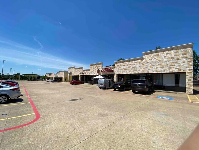

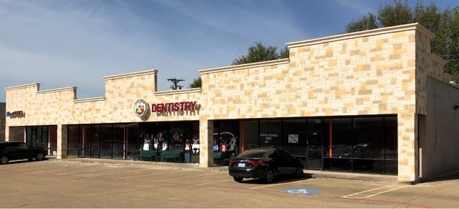
Property Detail
2501 N Main St
Dallas-Fort Worth-Arlington, TX
BEAR CREEK ESTATES-EULESS BLOCK 1 LOT C
00128856
TARRANT
Commercialnec
Texas
B and X Area of moderate flood hazard, usually the area between the limits of the 100-year and 500-year floods.
c
2025
0.88 AC
2025
Hurst/Euless/Bedford
113519
Dallas/Ft Worth
7,140 SF
NEARBY LISTINGS FOR SALE OR LEASE
DEMOGRAPHICS near 2501 N Main St
1 mile
3 mile
5 mile
2025 Total Population
18,255
82,161
199,815
2030 Population
19,350
86,288
209,493
Pop Growth 2025-2030
+ 6.00%
+ 5.02%
+ 4.84%
Average Age
39
40
39
2025 Total Households
7,423
33,310
81,505
HH Growth 2025-2030
+ 5.60%
+ 5.00%
+ 4.84%
Median Household Inc
$93,358
$94,460
$87,781
Avg Household Size
2.40
2.40
2.40
2025 Avg HH Vehicles
2.00
2.00
2.00
Median Home Value
$395,917
$424,710
$433,981
Median Year Built
1991
1988
1987
Nearby Places
Map Layers
Map Styles
 Street
 Aerial
Layers
 Traffic
 Biking
Places
Listings with unknown addresses are not visible on the map
- Restaurants
- Banks
- Shops
- Fitness
- Groceries
PUBLIC TRANSPORTATION
COMMUTER RAIL
Centreport Station (TRINITY RAILWAY - Dallas Area Rapid Transit (DART))
Drive
Walk
Distance
Centreport Station (TRINITY RAILWAY - Dallas Area Rapid Transit (DART))
10 min
5.3 mi
West Tex Yard Limit (TRINITY RAILWAY - Dallas Area Rapid Transit (DART))
Drive
Walk
Distance
West Tex Yard Limit (TRINITY RAILWAY - Dallas Area Rapid Transit (DART))
16 min
7.1 mi
AIRPORT
Dallas-Fort Worth International
Drive
Walk
Distance
Dallas-Fort Worth International
12 min
6.5 mi
Dallas Love Field
Drive
Walk
Distance
Dallas Love Field
27 min
18.5 mi
Freight Ports
Port of Shreveport
Drive
Walk
Distance
Port of Shreveport
237 min
217.8 mi
SALE & LEASE HISTORY
LISTING DATE
SALE/LEASE

Oct 06, 2021
For Sale
Aug 20, 2025
For Sale
Nearby Properties
Address
Land Use
TOTAL SIZE
Lot Size
Zoning
Address
Land Use
TOTAL SIZE
Lot Size
Zoning
624,642 SF
15.38 AC
Address
Land Use
TOTAL SIZE
Lot Size
Zoning
631,558 SF
15.49 AC
Address
Land Use
TOTAL SIZE
Lot Size
Zoning
394,769 SF
20.39 AC
Address
Land Use
TOTAL SIZE
Lot Size
Zoning
394,769 SF
20.36 AC
Address
Land Use
TOTAL SIZE
Lot Size
Zoning
468,250 SF
37.03 AC
Address
Land Use
TOTAL SIZE
Lot Size
Zoning
630,765 SF
321.80 AC
Address
Land Use
TOTAL SIZE
Lot Size
Zoning
401,397 SF
14.94 AC
Address
Land Use
TOTAL SIZE
Lot Size
Zoning
419,655 SF
20.44 AC
Address
Land Use
TOTAL SIZE
Lot Size
Zoning
443,420 SF
10.96 AC
Address
Land Use
TOTAL SIZE
Lot Size
Zoning
333,755 SF
19.06 AC
Address
Land Use
TOTAL SIZE
Lot Size
Zoning
363,849 SF
8.08 AC
Address
Land Use
TOTAL SIZE
Lot Size
Zoning
591,105 SF
46.67 AC
Address
Land Use
TOTAL SIZE
Lot Size
Zoning
348,842 SF
17.09 AC
Address
Land Use
TOTAL SIZE
Lot Size
Zoning
345,961 SF
14.73 AC
Address
Land Use
TOTAL SIZE
Lot Size
Zoning
344,326 SF
15.25 AC
Address
Land Use
TOTAL SIZE
Lot Size
Zoning
324.32 AC
Address
Land Use
TOTAL SIZE
Lot Size
Zoning
220,435 SF
14.97 AC
Address
Land Use
TOTAL SIZE
Lot Size
Zoning
230,666 SF
13.33 AC
Address
Land Use
TOTAL SIZE
Lot Size
Zoning
293,822 SF
18.80 AC
Address
Land Use
TOTAL SIZE
Lot Size
Zoning
300,000 SF
27.13 AC
Address
Land Use
TOTAL SIZE
Lot Size
Zoning
286,861 SF
13.38 AC
Address
Land Use
TOTAL SIZE
Lot Size
Zoning
236,016 SF
12.81 AC
Address
Land Use
TOTAL SIZE
Lot Size
Zoning
199,373 SF
12.98 AC
Address
Land Use
TOTAL SIZE
Lot Size
Zoning
214,908 SF
13.55 AC
Address
Land Use
TOTAL SIZE
Lot Size
Zoning
269,700 SF
48.40 AC
Address
Land Use
TOTAL SIZE
Lot Size
Zoning
198,800 SF
6.74 AC
Address
Land Use
TOTAL SIZE
Lot Size
Zoning
234,077 SF
12.16 AC
Address
Land Use
TOTAL SIZE
Lot Size
Zoning
400,438 SF
35.92 AC
Address
Land Use
TOTAL SIZE
Lot Size
Zoning
921,172 SF
105 AC
Address
Land Use
TOTAL SIZE
Lot Size
Zoning
257,108 SF
14.98 AC
The World's #1 Commercial Real Estate Marketplace
Connect with us
© 2026 CoStar Group
The information above has been obtained from sources believed reliable. While we do not doubt its accuracy we have not verified it and make no guarantee, warranty or representation about it. It is your responsibility to independently confirm its accuracy and completeness. Any projections, opinions, assumptions, or estimates used are for example only and do not represent the current or future performance of the property. The value of this transaction to you depends on tax and other factors which should be evaluated by your tax, financial, and legal advisors. You and your advisors should conduct a careful, independent investigation of the property to determine to your satisfaction the suitability of the property for your needs.