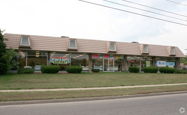
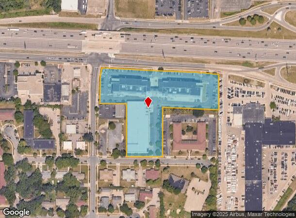
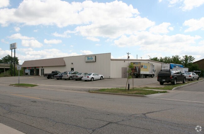
Property Record
2501 W Beltline Hwy, Madison, WI 53713
NEARBY LISTINGS FOR SALE OR LEASE
Property Detail
2501 W Beltline Hwy
Madison, WI
Certified Survey Map No 12388 As
0709-343-1001-5
CERTIFIED SURVEY MAP NO 12388 AS RECORDED IN DANE COUNTY REGISTER OF DEEDS IN VO LUME 77 PAGE 98 OF CERTIFIED SURVEYS LOT 1.
Commercialnec
Dane
X
Wisconsin
55025C0416G
1
2024
4.86 AC
2024
S Central Madison
001402
Milwaukee/Madison
404,794 SF
DEMOGRAPHICS near 2501 W Beltline Hwy
1 Mile
3 Mile
5 Mile
2024 Total Population
9,831
101,539
200,708
2029 Population
10,252
104,672
207,249
Pop Growth 2024-2029
+ 4.28%
+ 3.09%
+ 3.26%
Average Age
35
35
36
2024 Total Households
4,395
42,878
88,488
HH Growth 2024-2029
+ 4.41%
+ 3.40%
+ 3.53%
Median Household Inc
$49,963
$65,403
$66,224
Avg Household Size
2.20
2.20
2.10
2024 Avg HH Vehicles
1.00
1.00
1.00
Median Home Value
$316,046
$372,345
$361,499
Median Year Built
1985
1974
1977
Nearby Places
Map Layers
Map Styles
 Street
 Aerial
- Restaurants
- Banks
- Shops
- Fitness
- Groceries
PUBLIC TRANSPORTATION
AIRPORT
Dane County Regional/Truax Field
DRIVE
WALK
Distance
Dane County Regional/Truax Field
20 min
10.4 mi
Freight Ports
Port Milwaukee
DRIVE
WALK
Distance
Port Milwaukee
100 min
84.9 mi
Nearby Properties
Address
Land Use
TOTAL SIZE
Lot Size
Zoning
Address
Land Use
TOTAL SIZE
Lot Size
Zoning
8.42 AC
Address
Land Use
TOTAL SIZE
Lot Size
Zoning
466,963 SF
761.23 AC
PD
Address
Land Use
TOTAL SIZE
Lot Size
Zoning
21.49 AC
Address
Land Use
TOTAL SIZE
Lot Size
Zoning
89.21 AC
Address
Land Use
TOTAL SIZE
Lot Size
Zoning
169,224 SF
5.49 AC
CC-T
Address
Land Use
TOTAL SIZE
Lot Size
Zoning
460,603 SF
1.08 AC
PD
Address
Land Use
TOTAL SIZE
Lot Size
Zoning
16.45 AC
Address
Land Use
TOTAL SIZE
Lot Size
Zoning
18.97 AC
Address
Land Use
TOTAL SIZE
Lot Size
Zoning
230,268 SF
0.87 AC
UMX
Address
Land Use
TOTAL SIZE
Lot Size
Zoning
183,407 SF
2.71 AC
PD
Address
Land Use
TOTAL SIZE
Lot Size
Zoning
2.97 AC
Address
Land Use
TOTAL SIZE
Lot Size
Zoning
254,812 SF
0.64 AC
PD
Address
Land Use
TOTAL SIZE
Lot Size
Zoning
182,821 SF
1.19 AC
PD
Address
Land Use
TOTAL SIZE
Lot Size
Zoning
172,984 SF
1.59 AC
PD
Address
Land Use
TOTAL SIZE
Lot Size
Zoning
6.30 AC
Address
Land Use
TOTAL SIZE
Lot Size
Zoning
Address
Land Use
TOTAL SIZE
Lot Size
Zoning
14.47 AC
Address
Land Use
TOTAL SIZE
Lot Size
Zoning
24.62 AC
Address
Land Use
TOTAL SIZE
Lot Size
Zoning
3.21 AC
Address
Land Use
TOTAL SIZE
Lot Size
Zoning
234,075 SF
0.80 AC
UMX
Address
Land Use
TOTAL SIZE
Lot Size
Zoning
6.39 AC
Address
Land Use
TOTAL SIZE
Lot Size
Zoning
24,245 SF
2.23 AC
TSS
Address
Land Use
TOTAL SIZE
Lot Size
Zoning
13.98 AC
Address
Land Use
TOTAL SIZE
Lot Size
Zoning
209,268 SF
1.08 AC
PD
Address
Land Use
TOTAL SIZE
Lot Size
Zoning
237,225 SF
1.84 AC
PD
Address
Land Use
TOTAL SIZE
Lot Size
Zoning
3,085 SF
0.66 AC
UMX
Address
Land Use
TOTAL SIZE
Lot Size
Zoning
4.22 AC
Address
Land Use
TOTAL SIZE
Lot Size
Zoning
180,552 SF
1.66 AC
PD
Address
Land Use
TOTAL SIZE
Lot Size
Zoning
The World's #1 Commercial Real Estate Marketplace
Connect with us
© 2026 CoStar Group
The information above has been obtained from sources believed reliable. While we do not doubt its accuracy we have not verified it and make no guarantee, warranty or representation about it. It is your responsibility to independently confirm its accuracy and completeness. Any projections, opinions, assumptions, or estimates used are for example only and do not represent the current or future performance of the property. The value of this transaction to you depends on tax and other factors which should be evaluated by your tax, financial, and legal advisors. You and your advisors should conduct a careful, independent investigation of the property to determine to your satisfaction the suitability of the property for your needs.