Property Record
2502 S Main St, Taylor, TX 76574
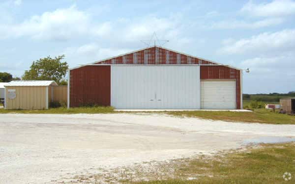

Property Detail
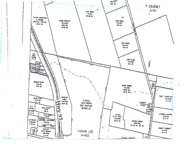
2502 S Main St
Austin-Round Rock-San Marcos, TX
S6582 - TALLEY SUB, LOT 2, ACRES 1.978
R371780
WILLIAMSON
Commercialnec
Texas
B and X Area of moderate flood hazard, usually the area between the limits of the 100-year and 500-year floods.
2
2024
1.98 AC
2025
Round Rock
021203
Austin
7,924 SF
NEARBY LISTINGS FOR SALE OR LEASE
DEMOGRAPHICS near 2502 S Main St
1 mile
3 mile
5 mile
2025 Total Population
392
11,851
21,026
2030 Population
452
13,590
24,075
Pop Growth 2025-2030
+ 15.31%
+ 14.67%
+ 14.50%
Average Age
41
39
40
2025 Total Households
139
4,441
7,879
HH Growth 2025-2030
+ 15.83%
+ 15.18%
+ 14.98%
Median Household Inc
$79,167
$64,021
$72,567
Avg Household Size
2.70
2.60
2.60
2025 Avg HH Vehicles
2.00
2.00
2.00
Median Home Value
$443,478
$359,982
$333,289
Median Year Built
1987
1977
1984
Nearby Places
Map Layers
Map Styles
 Street
 Aerial
Transit
 Traffic
 Biking
Places
Listings with unknown addresses are not visible on the map
- Restaurants
- Banks
- Shops
- Fitness
- Groceries
PUBLIC TRANSPORTATION
COMMUTER RAIL
Taylor Amtrak (Texas Eagle - Amtrak)
Drive
Walk
Distance
Taylor Amtrak (Texas Eagle - Amtrak)
4 min
2.0 mi
AIRPORT
Austin-Bergstrom International
Drive
Walk
Distance
Austin-Bergstrom International
56 min
43.5 mi
Freight Ports
Calhoun Port
Drive
Walk
Distance
Calhoun Port
213 min
177.1 mi
Nearby Properties
Address
Land Use
TOTAL SIZE
Lot Size
Zoning
Address
Land Use
TOTAL SIZE
Lot Size
Zoning
1,213.97 AC
Address
Land Use
TOTAL SIZE
Lot Size
Zoning
1,213.97 AC
Address
Land Use
TOTAL SIZE
Lot Size
Zoning
52,527 SF
1,213.97 AC
Address
Land Use
TOTAL SIZE
Lot Size
Zoning
5,060,050 SF
354.33 AC
Address
Land Use
TOTAL SIZE
Lot Size
Zoning
208,704 SF
20.56 AC
2-M1
Address
Land Use
TOTAL SIZE
Lot Size
Zoning
46.70 AC
Address
Land Use
TOTAL SIZE
Lot Size
Zoning
311,017 SF
39.81 AC
Address
Land Use
TOTAL SIZE
Lot Size
Zoning
133,666 SF
64.51 AC
2-M1
Address
Land Use
TOTAL SIZE
Lot Size
Zoning
68,657 SF
117.84 AC
2-M1
Address
Land Use
TOTAL SIZE
Lot Size
Zoning
128,023 SF
13.78 AC
2-M1
Address
Land Use
TOTAL SIZE
Lot Size
Zoning
110,004 SF
27.79 AC
2-M1
Address
Land Use
TOTAL SIZE
Lot Size
Zoning
625 SF
51.85 AC
Address
Land Use
TOTAL SIZE
Lot Size
Zoning
Address
Land Use
TOTAL SIZE
Lot Size
Zoning
39,913 SF
1.54 AC
1-B3
Address
Land Use
TOTAL SIZE
Lot Size
Zoning
Address
Land Use
TOTAL SIZE
Lot Size
Zoning
16,485 SF
6.75 AC
Address
Land Use
TOTAL SIZE
Lot Size
Zoning
29,096 SF
9.61 AC
Address
Land Use
TOTAL SIZE
Lot Size
Zoning
Address
Land Use
TOTAL SIZE
Lot Size
Zoning
35.12 AC
Address
Land Use
TOTAL SIZE
Lot Size
Zoning
64,600 SF
27.98 AC
Address
Land Use
TOTAL SIZE
Lot Size
Zoning
17,766 SF
0.77 AC
3-B1
Address
Land Use
TOTAL SIZE
Lot Size
Zoning
119,400 SF
14.03 AC
2-M1
Address
Land Use
TOTAL SIZE
Lot Size
Zoning
40,000 SF
7 AC
Address
Land Use
TOTAL SIZE
Lot Size
Zoning
50,050 SF
5.42 AC
Address
Land Use
TOTAL SIZE
Lot Size
Zoning
33,000 SF
0.38 AC
1-B3
Address
Land Use
TOTAL SIZE
Lot Size
Zoning
37,236 SF
1.20 AC
Address
Land Use
TOTAL SIZE
Lot Size
Zoning
65,906 SF
7.34 AC
Address
Land Use
TOTAL SIZE
Lot Size
Zoning
29,694 SF
5.64 AC
Address
Land Use
TOTAL SIZE
Lot Size
Zoning
116,792 SF
5.97 AC
2-M1
Address
Land Use
TOTAL SIZE
Lot Size
Zoning
18,798 SF
1.67 AC
The World's #1 Commercial Real Estate Marketplace
Connect with us
© 2026 CoStar Group
The information above has been obtained from sources believed reliable. While we do not doubt its accuracy we have not verified it and make no guarantee, warranty or representation about it. It is your responsibility to independently confirm its accuracy and completeness. Any projections, opinions, assumptions, or estimates used are for example only and do not represent the current or future performance of the property. The value of this transaction to you depends on tax and other factors which should be evaluated by your tax, financial, and legal advisors. You and your advisors should conduct a careful, independent investigation of the property to determine to your satisfaction the suitability of the property for your needs.