Property Record
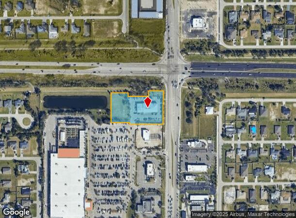
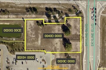
2502 Skyline Blvd, Cape Coral, FL 33914

NEARBY LISTINGS FOR SALE OR LEASE
Property Detail
2502 Skyline Blvd
34-44-23-C2-0040D.0000
West Cape Coral
Vehiclerentalsvehiclesales
WESTPOINT BLOCK 8060 AS DESC IN INST# 2010000249055
X
Lee
12071C0401G
Florida
2024
1.87 AC
2025
Cape Coral
010421
Southwest Florida
9,725 SF
Cape Coral-Fort Myers, FL
DEMOGRAPHICS near 2502 Skyline Blvd
1 Mile
3 Mile
5 Mile
2024 Total Population
8,048
82,233
166,953
2029 Population
9,474
97,268
198,550
Pop Growth 2024-2029
+ 17.72%
+ 18.28%
+ 18.93%
Average Age
40
43
45
2024 Total Households
2,926
31,719
67,030
HH Growth 2024-2029
+ 17.33%
+ 17.80%
+ 18.49%
Median Household Inc
$68,535
$68,389
$67,259
Avg Household Size
2.70
2.50
2.40
2024 Avg HH Vehicles
2.00
2.00
2.00
Median Home Value
$277,232
$281,695
$297,598
Median Year Built
1996
1997
1995
Nearby Places
Map Layers
Map Styles
 Street
 Aerial
- Restaurants
- Banks
- Shops
- Fitness
- Groceries
PUBLIC TRANSPORTATION
AIRPORT
Southwest Florida International
DRIVE
WALK
Distance
Southwest Florida International
34 min
20.8 mi
Punta Gorda
DRIVE
WALK
Distance
Punta Gorda
43 min
26.6 mi
Freight Ports
Port Manatee
DRIVE
WALK
Distance
Port Manatee
123 min
100.5 mi
Nearby Properties
Address
Land Use
TOTAL SIZE
Lot Size
Zoning
Address
Land Use
TOTAL SIZE
Lot Size
Zoning
441,999 SF
19.96 AC
R-3
Address
Land Use
TOTAL SIZE
Lot Size
Zoning
476,419 SF
36.49 AC
C1
Address
Land Use
TOTAL SIZE
Lot Size
Zoning
263,280 SF
19.99 AC
RML
Address
Land Use
TOTAL SIZE
Lot Size
Zoning
340,032 SF
30.58 AC
R1-A
Address
Land Use
TOTAL SIZE
Lot Size
Zoning
231,454 SF
14.53 AC
CC
Address
Land Use
TOTAL SIZE
Lot Size
Zoning
300,366 SF
10.61 AC
RPUD
Address
Land Use
TOTAL SIZE
Lot Size
Zoning
96,539 SF
74.71 AC
INST
Address
Land Use
TOTAL SIZE
Lot Size
Zoning
212,112 SF
33.92 AC
RD-D
Address
Land Use
TOTAL SIZE
Lot Size
Zoning
4.89 AC
C-1
Address
Land Use
TOTAL SIZE
Lot Size
Zoning
282,066 SF
39.45 AC
INS
Address
Land Use
TOTAL SIZE
Lot Size
Zoning
239,211 SF
56.31 AC
INST
Address
Land Use
TOTAL SIZE
Lot Size
Zoning
101,204 SF
12.34 AC
P1-D
Address
Land Use
TOTAL SIZE
Lot Size
Zoning
27.77 AC
RML
Address
Land Use
TOTAL SIZE
Lot Size
Zoning
158,176 SF
20 AC
R-1
Address
Land Use
TOTAL SIZE
Lot Size
Zoning
144,607 SF
20 AC
INS
Address
Land Use
TOTAL SIZE
Lot Size
Zoning
6.09 AC
MR
Address
Land Use
TOTAL SIZE
Lot Size
Zoning
149,829 SF
5.70 AC
R-3
Address
Land Use
TOTAL SIZE
Lot Size
Zoning
101,999 SF
7.17 AC
P-1
Address
Land Use
TOTAL SIZE
Lot Size
Zoning
135,838 SF
40 AC
R-1
Address
Land Use
TOTAL SIZE
Lot Size
Zoning
153,651 SF
17.17 AC
R1-B
Address
Land Use
TOTAL SIZE
Lot Size
Zoning
123,133 SF
8.26 AC
C
Address
Land Use
TOTAL SIZE
Lot Size
Zoning
147,599 SF
5.72 AC
RML
Address
Land Use
TOTAL SIZE
Lot Size
Zoning
142,379 SF
3.27 AC
Address
Land Use
TOTAL SIZE
Lot Size
Zoning
62,119 SF
6.50 AC
CORR
Address
Land Use
TOTAL SIZE
Lot Size
Zoning
28,560 SF
5.08 AC
P1-W
Address
Land Use
TOTAL SIZE
Lot Size
Zoning
102,818 SF
8.60 AC
CORR
Address
Land Use
TOTAL SIZE
Lot Size
Zoning
93,636 SF
4.46 AC
C-1
Address
Land Use
TOTAL SIZE
Lot Size
Zoning
47,423 SF
13.86 AC
R1-D
Address
Land Use
TOTAL SIZE
Lot Size
Zoning
102,906 SF
2.95 AC
C
Address
Land Use
TOTAL SIZE
Lot Size
Zoning
79,062 SF
5.15 AC
CORR
The World's #1 Commercial Real Estate Marketplace
Connect with us
© 2025 CoStar Group
The information above has been obtained from sources believed reliable. While we do not doubt its accuracy we have not verified it and make no guarantee, warranty or representation about it. It is your responsibility to independently confirm its accuracy and completeness. Any projections, opinions, assumptions, or estimates used are for example only and do not represent the current or future performance of the property. The value of this transaction to you depends on tax and other factors which should be evaluated by your tax, financial, and legal advisors. You and your advisors should conduct a careful, independent investigation of the property to determine to your satisfaction the suitability of the property for your needs.