Property Record
2504 Anderson Rd, Opelika, AL 36801
NEARBY LISTINGS FOR SALE OR LEASE
Property Detail
2504 Anderson Rd
Auburn-Opelika, AL
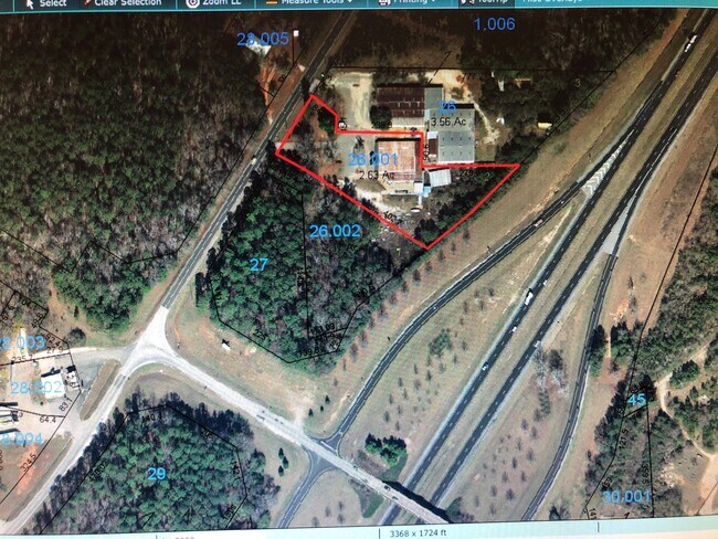
Deep Rock S/D Plat 26-151
03-08-34-0-000-026.000
LOT 3 DEEPROCK S/D PLAT 26-151 SEC 34 T20N R27E
Manufacturinglight
Lee
X
Alabama
01081C0090H
3
2025
3.56 AC
2025
Lee County
041200
Columbus GA
4,720 SF
DEMOGRAPHICS near 2504 Anderson Rd
1 Mile
3 Mile
5 Mile
2024 Total Population
1,011
8,619
26,788
2029 Population
1,122
9,516
29,376
Pop Growth 2024-2029
+ 10.98%
+ 10.41%
+ 9.66%
Average Age
42
41
41
2024 Total Households
389
3,471
10,712
HH Growth 2024-2029
+ 11.05%
+ 10.29%
+ 9.56%
Median Household Inc
$61,765
$57,049
$51,519
Avg Household Size
2.50
2.40
2.40
2024 Avg HH Vehicles
2.00
2.00
2.00
Median Home Value
$176,799
$178,167
$168,864
Median Year Built
1995
1993
1989
Nearby Places
Map Layers
Map Styles
 Street
 Aerial
- Restaurants
- Banks
- Shops
- Fitness
- Groceries
PUBLIC TRANSPORTATION
AIRPORT
Columbus
DRIVE
WALK
Distance
Columbus
43 min
32.5 mi
Freight Ports
Port of Panama City
DRIVE
WALK
Distance
Port of Panama City
262 min
199.8 mi
SALE & LEASE HISTORY
LISTING DATE
SALE/LEASE

Apr 09, 2020
For Sale
Nearby Properties
Address
Land Use
TOTAL SIZE
Lot Size
Zoning
Address
Land Use
TOTAL SIZE
Lot Size
Zoning
15,464 SF
105.62 AC
Address
Land Use
TOTAL SIZE
Lot Size
Zoning
177,673 SF
21.50 AC
Address
Land Use
TOTAL SIZE
Lot Size
Zoning
485,568 SF
104.20 AC
Address
Land Use
TOTAL SIZE
Lot Size
Zoning
213,785 SF
Address
Land Use
TOTAL SIZE
Lot Size
Zoning
401,660 SF
Address
Land Use
TOTAL SIZE
Lot Size
Zoning
271,921 SF
50 AC
Address
Land Use
TOTAL SIZE
Lot Size
Zoning
498,160 SF
29.90 AC
Address
Land Use
TOTAL SIZE
Lot Size
Zoning
13,800 SF
24.31 AC
Address
Land Use
TOTAL SIZE
Lot Size
Zoning
28,003 SF
41.72 AC
Address
Land Use
TOTAL SIZE
Lot Size
Zoning
26,018 SF
31.04 AC
Address
Land Use
TOTAL SIZE
Lot Size
Zoning
162,553 SF
50 AC
Address
Land Use
TOTAL SIZE
Lot Size
Zoning
173,736 SF
31.39 AC
Address
Land Use
TOTAL SIZE
Lot Size
Zoning
7,690 SF
21.24 AC
Address
Land Use
TOTAL SIZE
Lot Size
Zoning
5,260 SF
9.60 AC
Address
Land Use
TOTAL SIZE
Lot Size
Zoning
6,540 SF
Address
Land Use
TOTAL SIZE
Lot Size
Zoning
121,350 SF
Address
Land Use
TOTAL SIZE
Lot Size
Zoning
199,325 SF
14.48 AC
Address
Land Use
TOTAL SIZE
Lot Size
Zoning
142,391 SF
38.43 AC
Address
Land Use
TOTAL SIZE
Lot Size
Zoning
68,030 SF
Address
Land Use
TOTAL SIZE
Lot Size
Zoning
720 SF
14 AC
Address
Land Use
TOTAL SIZE
Lot Size
Zoning
7,854 SF
3.86 AC
Address
Land Use
TOTAL SIZE
Lot Size
Zoning
6,802 SF
17 AC
Address
Land Use
TOTAL SIZE
Lot Size
Zoning
80,882 SF
Address
Land Use
TOTAL SIZE
Lot Size
Zoning
64,712 SF
6.30 AC
Address
Land Use
TOTAL SIZE
Lot Size
Zoning
8,520 SF
10 AC
Address
Land Use
TOTAL SIZE
Lot Size
Zoning
2,009 SF
4.60 AC
Address
Land Use
TOTAL SIZE
Lot Size
Zoning
80,500 SF
Address
Land Use
TOTAL SIZE
Lot Size
Zoning
60,150 SF
Address
Land Use
TOTAL SIZE
Lot Size
Zoning
6,480 SF
9.22 AC
Address
Land Use
TOTAL SIZE
Lot Size
Zoning
1,708 SF
54.71 AC
The World's #1 Commercial Real Estate Marketplace
Connect with us
© 2026 CoStar Group
The information above has been obtained from sources believed reliable. While we do not doubt its accuracy we have not verified it and make no guarantee, warranty or representation about it. It is your responsibility to independently confirm its accuracy and completeness. Any projections, opinions, assumptions, or estimates used are for example only and do not represent the current or future performance of the property. The value of this transaction to you depends on tax and other factors which should be evaluated by your tax, financial, and legal advisors. You and your advisors should conduct a careful, independent investigation of the property to determine to your satisfaction the suitability of the property for your needs.