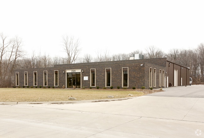
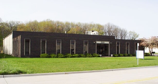
Property Record
2505 Industrial Row Dr, Troy, MI 48084

NEARBY LISTINGS FOR SALE OR LEASE
Property Detail
2505 Industrial Row Dr
Detroit-Warren-Dearborn, MI
Birmingham Airport Sub #2
20-32-152-017
T2N, R11E, SEC 32 BIRMINGHAM AIRPORT SUB NO. 2 LOT 30
Industrialgeneral
Oakland
X
Michigan
26125C0541F
30
2024
1.12 AC
2022
Troy Area West
197702
Detroit
14,000 SF
DEMOGRAPHICS near 2505 Industrial Row Dr
1 Mile
3 Mile
5 Mile
2024 Total Population
9,513
107,536
262,682
2029 Population
9,435
106,666
260,230
Pop Growth 2024-2029
(0.82%)
(0.81%)
(0.93%)
Average Age
40
41
42
2024 Total Households
5,007
48,782
113,596
HH Growth 2024-2029
(0.88%)
(0.85%)
(0.91%)
Median Household Inc
$85,379
$98,188
$96,174
Avg Household Size
1.90
2.20
2.30
2024 Avg HH Vehicles
2.00
2.00
2.00
Median Home Value
$239,867
$321,735
$306,114
Median Year Built
1967
1961
1962
Nearby Places
Map Layers
Map Styles
 Street
 Aerial
- Restaurants
- Banks
- Shops
- Fitness
- Groceries
PUBLIC TRANSPORTATION
COMMUTER RAIL
DRIVE
WALK
Distance
4 min
17 min
0.9 mi
DRIVE
WALK
Distance
13 min
5.6 mi
AIRPORT
Windsor International
DRIVE
WALK
Distance
Windsor International
52 min
29.1 mi
Detroit Metro Wayne County
DRIVE
WALK
Distance
Detroit Metro Wayne County
54 min
32.4 mi
SALE & LEASE HISTORY
LISTING DATE
SALE/LEASE

Feb 20, 2025
For Sale
Nearby Properties
Address
Land Use
TOTAL SIZE
Lot Size
Zoning
Address
Land Use
TOTAL SIZE
Lot Size
Zoning
399,735 SF
19.71 AC
B2
Address
Land Use
TOTAL SIZE
Lot Size
Zoning
272,233 SF
90.90 AC
Address
Land Use
TOTAL SIZE
Lot Size
Zoning
224,766 SF
19.92 AC
B2
Address
Land Use
TOTAL SIZE
Lot Size
Zoning
300,925 SF
10.13 AC
Address
Land Use
TOTAL SIZE
Lot Size
Zoning
512,475 SF
20.02 AC
Address
Land Use
TOTAL SIZE
Lot Size
Zoning
512,471 SF
21 AC
Address
Land Use
TOTAL SIZE
Lot Size
Zoning
15.32 AC
GEN BUS
Address
Land Use
TOTAL SIZE
Lot Size
Zoning
111,030 SF
0.97 AC
BI
Address
Land Use
TOTAL SIZE
Lot Size
Zoning
149,395 SF
1.02 AC
BI
Address
Land Use
TOTAL SIZE
Lot Size
Zoning
208,296 SF
8.16 AC
OSC
Address
Land Use
TOTAL SIZE
Lot Size
Zoning
157,500 SF
20.79 AC
OM
Address
Land Use
TOTAL SIZE
Lot Size
Zoning
272,233 SF
9.09 AC
OSC
Address
Land Use
TOTAL SIZE
Lot Size
Zoning
143,160 SF
0.84 AC
BI
Address
Land Use
TOTAL SIZE
Lot Size
Zoning
399,212 SF
26.18 AC
RM1
Address
Land Use
TOTAL SIZE
Lot Size
Zoning
236,140 SF
1.67 AC
BI
Address
Land Use
TOTAL SIZE
Lot Size
Zoning
12.16 AC
PUD
Address
Land Use
TOTAL SIZE
Lot Size
Zoning
99,661 SF
0.62 AC
Address
Land Use
TOTAL SIZE
Lot Size
Zoning
427,945 SF
18.26 AC
OSC
Address
Land Use
TOTAL SIZE
Lot Size
Zoning
250,868 SF
6 AC
OSC
Address
Land Use
TOTAL SIZE
Lot Size
Zoning
160,796 SF
1.84 AC
Address
Land Use
TOTAL SIZE
Lot Size
Zoning
365,104 SF
2.03 AC
Address
Land Use
TOTAL SIZE
Lot Size
Zoning
300,925 SF
10.13 AC
OSC
Address
Land Use
TOTAL SIZE
Lot Size
Zoning
300,924 SF
10.13 AC
Address
Land Use
TOTAL SIZE
Lot Size
Zoning
301,728 SF
2.83 AC
B2
Address
Land Use
TOTAL SIZE
Lot Size
Zoning
119,732 SF
3.77 AC
Address
Land Use
TOTAL SIZE
Lot Size
Zoning
83,244 SF
0.38 AC
Address
Land Use
TOTAL SIZE
Lot Size
Zoning
16,022 SF
4.07 AC
OSC
Address
Land Use
TOTAL SIZE
Lot Size
Zoning
150,240 SF
10.70 AC
OSC
Address
Land Use
TOTAL SIZE
Lot Size
Zoning
72,457 SF
5.60 AC
OFFICE SVC
Address
Land Use
TOTAL SIZE
Lot Size
Zoning
206,913 SF
16.99 AC
O1
The World's #1 Commercial Real Estate Marketplace
Connect with us
© 2025 CoStar Group
The information above has been obtained from sources believed reliable. While we do not doubt its accuracy we have not verified it and make no guarantee, warranty or representation about it. It is your responsibility to independently confirm its accuracy and completeness. Any projections, opinions, assumptions, or estimates used are for example only and do not represent the current or future performance of the property. The value of this transaction to you depends on tax and other factors which should be evaluated by your tax, financial, and legal advisors. You and your advisors should conduct a careful, independent investigation of the property to determine to your satisfaction the suitability of the property for your needs.